
Original file (2,592 × 1,944 pixels, file size: 6.75 MB, MIME type: image/jpeg)
| This is a file from the
Wikimedia Commons. Information from its
description page there is shown below. Commons is a freely licensed media file repository. You can help. |
| Description |
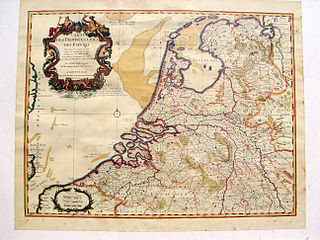
English: Map of The Netherlands, publication date circa 1743
Nederlands: Kaart van Nederland, publicatie ca 1743
Français : Carte des Provinces Unies des Pays Bas, par G. de L'Isle, A Amsterdam 1743 |
| Date | |
| Source | Edition Covens & Mortier 1743 from 1702 original. |
| Author | Hans Erren |
| Other versions | Derivative works of this file: Broad Fourteens delisle 1743.jpg |
published by Covens & Mortier, Amsterdam
|
This work is in the public domain in its country of origin and other countries and areas where the copyright term is the author's life plus 70 years or fewer.
| |
| This file has been identified as being free of known restrictions under copyright law, including all related and neighboring rights. | |
File history
Click on a date/time to view the file as it appeared at that time.
| Date/Time | Thumbnail | Dimensions | User | Comment | |
|---|---|---|---|---|---|
| current | 18:47, 30 May 2011 |
| 2,592 × 1,944 (6.75 MB) | Hans Erren | colour correction |
| 20:56, 26 June 2010 |
 | 2,592 × 1,944 (5.27 MB) | Hans Erren | {{Information |Description={{en|1=Map of The Netherlands, publication date circa 1743}} {{nl|1=Kaart van Nederland, publicatie ca 1743}} {{fr|1=Carte des Provinces Unies des Pays Bas, par G. de L'Isle, A Amsterdam 1743}} |Source={{own}} |Author=[[User:Han |
File usage
Global file usage
The following other wikis use this file:
- Usage on ar.wikipedia.org
- Usage on hu.wikipedia.org
- Usage on nl.wikipedia.org
- Usage on pt.wikipedia.org
Metadata
Original file (2,592 × 1,944 pixels, file size: 6.75 MB, MIME type: image/jpeg)
| This is a file from the
Wikimedia Commons. Information from its
description page there is shown below. Commons is a freely licensed media file repository. You can help. |
| Description |
English: Map of The Netherlands, publication date circa 1743
Nederlands: Kaart van Nederland, publicatie ca 1743
Français : Carte des Provinces Unies des Pays Bas, par G. de L'Isle, A Amsterdam 1743 |
| Date | |
| Source | Edition Covens & Mortier 1743 from 1702 original. |
| Author | Hans Erren |
| Other versions | Derivative works of this file: Broad Fourteens delisle 1743.jpg |
published by Covens & Mortier, Amsterdam
|
This work is in the public domain in its country of origin and other countries and areas where the copyright term is the author's life plus 70 years or fewer.
| |
| This file has been identified as being free of known restrictions under copyright law, including all related and neighboring rights. | |
File history
Click on a date/time to view the file as it appeared at that time.
| Date/Time | Thumbnail | Dimensions | User | Comment | |
|---|---|---|---|---|---|
| current | 18:47, 30 May 2011 |
| 2,592 × 1,944 (6.75 MB) | Hans Erren | colour correction |
| 20:56, 26 June 2010 |
| 2,592 × 1,944 (5.27 MB) | Hans Erren | {{Information |Description={{en|1=Map of The Netherlands, publication date circa 1743}} {{nl|1=Kaart van Nederland, publicatie ca 1743}} {{fr|1=Carte des Provinces Unies des Pays Bas, par G. de L'Isle, A Amsterdam 1743}} |Source={{own}} |Author=[[User:Han |
File usage
Global file usage
The following other wikis use this file:
- Usage on ar.wikipedia.org
- Usage on hu.wikipedia.org
- Usage on nl.wikipedia.org
- Usage on pt.wikipedia.org