
Size of this preview:
789 × 599 pixels. Other resolutions:
316 × 240 pixels |
632 × 480 pixels |
1,011 × 768 pixels |
1,280 × 972 pixels |
2,560 × 1,945 pixels |
3,091 × 2,348 pixels.
Original file (3,091 × 2,348 pixels, file size: 3.21 MB, MIME type: image/jpeg)
| This is a file from the
Wikimedia Commons. Information from its
description page there is shown below. Commons is a freely licensed media file repository. You can help. |
Summary
| Description |
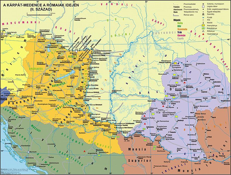
Magyar: Pannonia 2. századi térképe English: Pannonia in the 2. century |
| Date | |
| Source | http://ebedszu.net/zsolt/portfolio/index.php – scroll for searching this map ( direct link) |
| Author | Zsolt Horváth |
| Permission ( Reusing this file) |
Permission: Az oldalon lévő térképek/adatok/szövegek CC-BY-SA-3.0 licenc alatt használhatók fel (szabadon felhasználhatóak, amennyiben forrásként megjelölöd, hogy honnan származik). Ez lehetőleg a nevem és a honlapom elérési útjának megadásával történjen. |
This file, which was originally posted to
http://ebedszu.net/zsolt/portfolio/index.php – scroll for searching this map (
direct link), was reviewed on 18 July 2016 by
reviewer
Rodrigolopes, who confirmed that it was available there under the stated license on that date.
|
Licensing
Zsolt Horváth, the copyright holder of this work, hereby publishes it under the following license:
This file is licensed under the
Creative Commons
Attribution-Share Alike 3.0 Unported license.
Attribution: Zsolt Horváth
- You are free:
- to share – to copy, distribute and transmit the work
- to remix – to adapt the work
- Under the following conditions:
- attribution – You must give appropriate credit, provide a link to the license, and indicate if changes were made. You may do so in any reasonable manner, but not in any way that suggests the licensor endorses you or your use.
- share alike – If you remix, transform, or build upon the material, you must distribute your contributions under the same or compatible license as the original.
Original upload log
The original description page was
here. All following user names refer to hu.wikipedia.
| Date/Time | Dimensions | User | Comment |
|---|---|---|---|
| 2014-08-23 21:08 | 3091×2348× (3370593 bytes) | Regasterios | újra: a térkép frissített változata |
| 2014-08-23 08:55 | 3091×2348× (3370593 bytes) | Regasterios | a térkép frissített változatának feltöltése a mostani webhelyről |
| 2009-09-19 12:19 | 2061×1565× (1026421 bytes) | Laszlovszky András | {{Információ | leírás = Pannonia 2. századi térképe | forrás = http://lazarus.elte.hu/~hzsolt/terkep/pannonia_nagy.jpg | dátum = | helyszín = | szerző = Horváth Zsolt | engedély = szabad kép, fo |
File history
Click on a date/time to view the file as it appeared at that time.
| Date/Time | Thumbnail | Dimensions | User | Comment | |
|---|---|---|---|---|---|
| current | 08:23, 7 December 2015 |
| 3,091 × 2,348 (3.21 MB) | Regasterios | Transferred from hu.wikipedia |
File usage
The following pages on the English Wikipedia use this file (pages on other projects are not listed):
Global file usage
The following other wikis use this file:
- Usage on arz.wikipedia.org
- Usage on es.wikipedia.org
- Usage on fr.wikipedia.org
- Usage on hu.wikipedia.org
- Usage on pl.wikipedia.org
Size of this preview:
789 × 599 pixels. Other resolutions:
316 × 240 pixels |
632 × 480 pixels |
1,011 × 768 pixels |
1,280 × 972 pixels |
2,560 × 1,945 pixels |
3,091 × 2,348 pixels.
Original file (3,091 × 2,348 pixels, file size: 3.21 MB, MIME type: image/jpeg)
| This is a file from the
Wikimedia Commons. Information from its
description page there is shown below. Commons is a freely licensed media file repository. You can help. |
Summary
| Description |
Magyar: Pannonia 2. századi térképe English: Pannonia in the 2. century |
| Date | |
| Source | http://ebedszu.net/zsolt/portfolio/index.php – scroll for searching this map ( direct link) |
| Author | Zsolt Horváth |
| Permission ( Reusing this file) |
Permission: Az oldalon lévő térképek/adatok/szövegek CC-BY-SA-3.0 licenc alatt használhatók fel (szabadon felhasználhatóak, amennyiben forrásként megjelölöd, hogy honnan származik). Ez lehetőleg a nevem és a honlapom elérési útjának megadásával történjen. |
This file, which was originally posted to
http://ebedszu.net/zsolt/portfolio/index.php – scroll for searching this map (
direct link), was reviewed on 18 July 2016 by
reviewer
Rodrigolopes, who confirmed that it was available there under the stated license on that date.
|
Licensing
Zsolt Horváth, the copyright holder of this work, hereby publishes it under the following license:
This file is licensed under the
Creative Commons
Attribution-Share Alike 3.0 Unported license.
Attribution: Zsolt Horváth
- You are free:
- to share – to copy, distribute and transmit the work
- to remix – to adapt the work
- Under the following conditions:
- attribution – You must give appropriate credit, provide a link to the license, and indicate if changes were made. You may do so in any reasonable manner, but not in any way that suggests the licensor endorses you or your use.
- share alike – If you remix, transform, or build upon the material, you must distribute your contributions under the same or compatible license as the original.
Original upload log
The original description page was
here. All following user names refer to hu.wikipedia.
| Date/Time | Dimensions | User | Comment |
|---|---|---|---|
| 2014-08-23 21:08 | 3091×2348× (3370593 bytes) | Regasterios | újra: a térkép frissített változata |
| 2014-08-23 08:55 | 3091×2348× (3370593 bytes) | Regasterios | a térkép frissített változatának feltöltése a mostani webhelyről |
| 2009-09-19 12:19 | 2061×1565× (1026421 bytes) | Laszlovszky András | {{Információ | leírás = Pannonia 2. századi térképe | forrás = http://lazarus.elte.hu/~hzsolt/terkep/pannonia_nagy.jpg | dátum = | helyszín = | szerző = Horváth Zsolt | engedély = szabad kép, fo |
File history
Click on a date/time to view the file as it appeared at that time.
| Date/Time | Thumbnail | Dimensions | User | Comment | |
|---|---|---|---|---|---|
| current | 08:23, 7 December 2015 |
| 3,091 × 2,348 (3.21 MB) | Regasterios | Transferred from hu.wikipedia |
File usage
The following pages on the English Wikipedia use this file (pages on other projects are not listed):
Global file usage
The following other wikis use this file:
- Usage on arz.wikipedia.org
- Usage on es.wikipedia.org
- Usage on fr.wikipedia.org
- Usage on hu.wikipedia.org
- Usage on pl.wikipedia.org