
Original file (SVG file, nominally 5,416 × 4,237 pixels, file size: 381 KB)
| This is a file from the
Wikimedia Commons. Information from its
description page there is shown below. Commons is a freely licensed media file repository. You can help. |
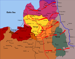
Legend
|
Germany
Latvia
Estonia
Poland (without disputed Vilnius and Suvalkai Regions)
Lithuania (de facto borders in 1921)
|
Klaipėda Region (detached from Germany by the Treaty of Versailles)
Suvalkai Region (disputed between Poland and Lithuania)
Vilnius Region (disputed between Poland and Lithuania)
|
Curzon Line (December 1919) Latvian–Lithuanian–Polish – Soviet front line in January 1919 German–Soviet front line in March 1918 during World War I (at the time of the treaty of Brest-Litovsk) Border of Lithuania (1945 – present) |
Red arrows - Main directions of Soviet attacks following retreating German army |
Note: all cities have their current names, except for three cities in the Kaliningrad Oblast as their names were radically changed after the World War II.
Summary
| Description | Polish-Soviet & Lithuanian-Soviet & Latvian-Soviet Wars in 1919: Soviet attacks. The map shows incorrect borders between Poland and Germany. The borders shown would be later decreed by the Treaty of Versailles, which was not signed until June 28, 1919, and imposed still later. |
| Date | |
| Source | Self-made from scratch using Inkscape. Based on (2001) Lietuvos istorijos atlasas, Vaga: Vilnius, pg. 39 |
| Author | Renata3 |
| Permission ( Reusing this file) |
GFDL & all CC-BY-SA |
Licensing

|
Permission is granted to copy, distribute and/or modify this document under the terms of the GNU Free Documentation License, Version 1.2 or any later version published by the Free Software Foundation; with no Invariant Sections, no Front-Cover Texts, and no Back-Cover Texts. A copy of the license is included in the section entitled GNU Free Documentation License. |
- You are free:
- to share – to copy, distribute and transmit the work
- to remix – to adapt the work
- Under the following conditions:
- attribution – You must give appropriate credit, provide a link to the license, and indicate if changes were made. You may do so in any reasonable manner, but not in any way that suggests the licensor endorses you or your use.
- share alike – If you remix, transform, or build upon the material, you must distribute your contributions under the same or compatible license as the original.
File history
Click on a date/time to view the file as it appeared at that time.
| Date/Time | Thumbnail | Dimensions | User | Comment | |
|---|---|---|---|---|---|
| current | 03:53, 14 April 2008 |
| 5,416 × 4,237 (381 KB) | Renata3 | change colors |
| 19:32, 6 April 2008 |
 | 5,416 × 4,237 (376 KB) | Renata3 | == Legend == {| |- | width=25% valign=top| {{legend|#d35fbc|Germany}} {{legend|#e9afc6|Latvia}} {{legend|#e9c6af|Estonia}} {{legend|#9955ff|Poland (without disputed Vilnius and Suvalkai Regions)}} {{legend|#e580ff|Lithuania (''de facto'' borders in 1921 |
File usage
Global file usage
The following other wikis use this file:
- Usage on ar.wikipedia.org
- Usage on azb.wikipedia.org
- Usage on be-tarask.wikipedia.org
- Usage on be.wikipedia.org
- Usage on et.wikipedia.org
- Usage on fi.wikipedia.org
- Usage on fr.wikipedia.org
- Usage on hr.wikipedia.org
- Usage on hu.wikipedia.org
- Usage on it.wikipedia.org
- Usage on ja.wikipedia.org
- Usage on lt.wikipedia.org
- Usage on lv.wikipedia.org
- Usage on mk.wikipedia.org
- Usage on no.wikipedia.org
- Usage on pl.wikipedia.org
- Usage on pt.wikipedia.org
- Usage on ro.wikipedia.org
- Usage on sr.wikipedia.org
- Usage on tr.wikipedia.org
- Usage on uk.wikipedia.org
- Usage on uz.wikipedia.org
- Usage on www.wikidata.org
- Usage on zh.wikipedia.org
Original file (SVG file, nominally 5,416 × 4,237 pixels, file size: 381 KB)
| This is a file from the
Wikimedia Commons. Information from its
description page there is shown below. Commons is a freely licensed media file repository. You can help. |
Legend
|
Germany
Latvia
Estonia
Poland (without disputed Vilnius and Suvalkai Regions)
Lithuania (de facto borders in 1921)
|
Klaipėda Region (detached from Germany by the Treaty of Versailles)
Suvalkai Region (disputed between Poland and Lithuania)
Vilnius Region (disputed between Poland and Lithuania)
|
Curzon Line (December 1919) Latvian–Lithuanian–Polish – Soviet front line in January 1919 German–Soviet front line in March 1918 during World War I (at the time of the treaty of Brest-Litovsk) Border of Lithuania (1945 – present) |
Red arrows - Main directions of Soviet attacks following retreating German army |
Note: all cities have their current names, except for three cities in the Kaliningrad Oblast as their names were radically changed after the World War II.
Summary
| Description | Polish-Soviet & Lithuanian-Soviet & Latvian-Soviet Wars in 1919: Soviet attacks. The map shows incorrect borders between Poland and Germany. The borders shown would be later decreed by the Treaty of Versailles, which was not signed until June 28, 1919, and imposed still later. |
| Date | |
| Source | Self-made from scratch using Inkscape. Based on (2001) Lietuvos istorijos atlasas, Vaga: Vilnius, pg. 39 |
| Author | Renata3 |
| Permission ( Reusing this file) |
GFDL & all CC-BY-SA |
Licensing
|
|
Permission is granted to copy, distribute and/or modify this document under the terms of the GNU Free Documentation License, Version 1.2 or any later version published by the Free Software Foundation; with no Invariant Sections, no Front-Cover Texts, and no Back-Cover Texts. A copy of the license is included in the section entitled GNU Free Documentation License. |
- You are free:
- to share – to copy, distribute and transmit the work
- to remix – to adapt the work
- Under the following conditions:
- attribution – You must give appropriate credit, provide a link to the license, and indicate if changes were made. You may do so in any reasonable manner, but not in any way that suggests the licensor endorses you or your use.
- share alike – If you remix, transform, or build upon the material, you must distribute your contributions under the same or compatible license as the original.
File history
Click on a date/time to view the file as it appeared at that time.
| Date/Time | Thumbnail | Dimensions | User | Comment | |
|---|---|---|---|---|---|
| current | 03:53, 14 April 2008 |
| 5,416 × 4,237 (381 KB) | Renata3 | change colors |
| 19:32, 6 April 2008 |
| 5,416 × 4,237 (376 KB) | Renata3 | == Legend == {| |- | width=25% valign=top| {{legend|#d35fbc|Germany}} {{legend|#e9afc6|Latvia}} {{legend|#e9c6af|Estonia}} {{legend|#9955ff|Poland (without disputed Vilnius and Suvalkai Regions)}} {{legend|#e580ff|Lithuania (''de facto'' borders in 1921 |
File usage
Global file usage
The following other wikis use this file:
- Usage on ar.wikipedia.org
- Usage on azb.wikipedia.org
- Usage on be-tarask.wikipedia.org
- Usage on be.wikipedia.org
- Usage on et.wikipedia.org
- Usage on fi.wikipedia.org
- Usage on fr.wikipedia.org
- Usage on hr.wikipedia.org
- Usage on hu.wikipedia.org
- Usage on it.wikipedia.org
- Usage on ja.wikipedia.org
- Usage on lt.wikipedia.org
- Usage on lv.wikipedia.org
- Usage on mk.wikipedia.org
- Usage on no.wikipedia.org
- Usage on pl.wikipedia.org
- Usage on pt.wikipedia.org
- Usage on ro.wikipedia.org
- Usage on sr.wikipedia.org
- Usage on tr.wikipedia.org
- Usage on uk.wikipedia.org
- Usage on uz.wikipedia.org
- Usage on www.wikidata.org
- Usage on zh.wikipedia.org