
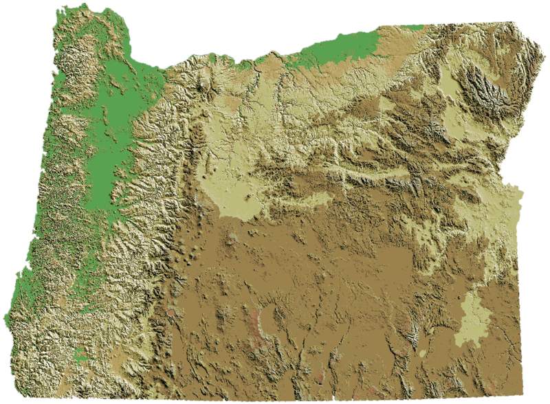
Original file (1,086 × 798 pixels, file size: 327 KB, MIME type: image/png)
| This is a file from the
Wikimedia Commons. Information from its
description page there is shown below. Commons is a freely licensed media file repository. You can help. |
Summary
| Description | Oregon DEM relief map |
| Date | |
| Source | cropped and 5° ccw rotated image:Oregon_DEM_relief_map.gif to level southern border. |
| Author | USGS + EncMstr |
Oregon DEM relief map, key.
Licensing
This image is in the
public domain in the United States because it only contains materials that originally came from the
United States Geological Survey, an agency of the
United States Department of the Interior. For more information, see
the official USGS copyright policy.
|
Source
- Website: http://wwwflag.wr.usgs.gov/USGSFlag/Data/maps/OregonDEM.html (link out of date, unable to find new URL)
- Image: http://wwwflag.wr.usgs.gov/USGSFlag/Data/maps/Oregon.gif (link out of date, unable to find new URL)
File history
Click on a date/time to view the file as it appeared at that time.
| Date/Time | Thumbnail | Dimensions | User | Comment | |
|---|---|---|---|---|---|
| current | 01:59, 23 May 2007 |
| 1,086 × 798 (327 KB) | Peteforsyth | copied Cacophany's color-reversal into the PNG version |
| 01:22, 24 February 2007 |
 | 1,074 × 790 (319 KB) | Cacophony | Transparent borders | |
| 21:10, 26 November 2006 |
 | 1,097 × 806 (418 KB) | EncMstr | {{Information |Description=Oregon DEM relief map |Source=cropped and 5° ccw rotated image:Oregon_DEM_relief_map.gif to level southern border. |date=2006-11-26 | author=USGS + EncMstr}} Category:Oregon maps Oregon DEM relief map, [[:Image:Elevl |
File usage
More than 100 pages use this file. The following list shows the first 100 pages that use this file only. A full list is available.
- Talk:1992 Oregon Ballot Measure 9
- Talk:Baker County, Oregon
- Talk:Beaverton, Oregon
- Talk:Benton County, Oregon
- Talk:Black Francis
- Talk:Broderbund
- Talk:Carl Barks
- Talk:Cascade Range
- Talk:Cedar Mill, Oregon
- Talk:Chuck Palahniuk
- Talk:Clackamas County, Oregon
- Talk:Clatsop County, Oregon
- Talk:Columbia County, Oregon
- Talk:Columbia River
- Talk:Confederated Tribes of Siletz Indians
- Talk:Confluence Project
- Talk:Coos County, Oregon
- Talk:Corvallis, Oregon
- Talk:Crook County, Oregon
- Talk:Curry County, Oregon
- Talk:D. B. Cooper
- Talk:Dale Murphy
- Talk:Deschutes County, Oregon
- Talk:Deschutes River Woods, Oregon
- Talk:Douglas County, Oregon
- Talk:E. E. Smith
- Talk:Elephant (2003 film)
- Talk:Eugene, Oregon
- Talk:Everclear (band)
- Talk:Flag of Oregon
- Talk:Footbag
- Talk:Fort Vancouver
- Talk:Gary Snyder
- Talk:Gilliam County, Oregon
- Talk:Grant County, Oregon
- Talk:Harney County, Oregon
- Talk:Hood River County, Oregon
- Talk:Hudson's Bay Company
- Talk:Jackson County, Oregon
- Talk:James J. Hill
- Talk:Jefferson County, Oregon
- Talk:Joaquin Miller
- Talk:John McLoughlin
- Talk:John Zerzan
- Talk:Josephine County, Oregon
- Talk:Ken Kesey
- Talk:Kit Carson
- Talk:Klamath County, Oregon
- Talk:Lake County, Oregon
- Talk:Lane County, Oregon
- Talk:Lewis & Clark College
- Talk:Lincoln County, Oregon
- Talk:Linn County, Oregon
- Talk:Linus Pauling
- Talk:Linus Torvalds
- Talk:List of Oregon ballot measures
- Talk:List of counties in Oregon
- Talk:MAX Light Rail
- Talk:Malheur County, Oregon
- Talk:Manifest destiny
- Talk:Marion County, Oregon
- Talk:Matt Groening
- Talk:Modoc War
- Talk:Modoc people
- Talk:Morrow County, Oregon
- Talk:Mount Jefferson (Oregon)
- Talk:Multnomah County, Oregon
- Talk:Oliver Otis Howard
- Talk:Oregon City, Oregon
- Talk:Paul Simon (politician)
- Talk:Polk County, Oregon
- Talk:Portland, Oregon
- Talk:Portland International Airport
- Talk:Randal L. Schwartz
- Talk:Reed College
- Talk:Sacagawea
- Talk:Sandy, Oregon
- Talk:Sherman County, Oregon
- Talk:Sunset High School (Beaverton, Oregon)
- Talk:Theodore Sturgeon
- Talk:Thomas Hart Benton (senator)
- Talk:Thomas Mapfumo
- Talk:Thunderbird and Whale
- Talk:Tillamook County, Oregon
- Talk:Tom McCall
- Talk:Tonya Harding
- Talk:Umatilla County, Oregon
- Talk:Union County, Oregon
- Talk:Urban growth boundary
- Talk:Ursula K. Le Guin
- Talk:Valerie Harper
- Talk:Vancouver, Washington
- Talk:Vladimir Nabokov
- Talk:Wallowa County, Oregon
- Talk:Ward Cunningham
- Talk:Wasco County, Oregon
- Talk:Washington County, Oregon
- Talk:West Coast of the United States
- Talk:Wheeler County, Oregon
- Talk:William Clark
View more links to this file.
Global file usage
The following other wikis use this file:
- Usage on ar.wikipedia.org
- Usage on en.wikiversity.org
- Usage on fr.wikipedia.org
- Usage on ja.wikipedia.org
- Usage on la.wikipedia.org
- Usage on pt.wikipedia.org
Original file (1,086 × 798 pixels, file size: 327 KB, MIME type: image/png)
| This is a file from the
Wikimedia Commons. Information from its
description page there is shown below. Commons is a freely licensed media file repository. You can help. |
Summary
| Description | Oregon DEM relief map |
| Date | |
| Source | cropped and 5° ccw rotated image:Oregon_DEM_relief_map.gif to level southern border. |
| Author | USGS + EncMstr |
Oregon DEM relief map, key.
Licensing
This image is in the
public domain in the United States because it only contains materials that originally came from the
United States Geological Survey, an agency of the
United States Department of the Interior. For more information, see
the official USGS copyright policy.
|
Source
- Website: http://wwwflag.wr.usgs.gov/USGSFlag/Data/maps/OregonDEM.html (link out of date, unable to find new URL)
- Image: http://wwwflag.wr.usgs.gov/USGSFlag/Data/maps/Oregon.gif (link out of date, unable to find new URL)
File history
Click on a date/time to view the file as it appeared at that time.
| Date/Time | Thumbnail | Dimensions | User | Comment | |
|---|---|---|---|---|---|
| current | 01:59, 23 May 2007 |
| 1,086 × 798 (327 KB) | Peteforsyth | copied Cacophany's color-reversal into the PNG version |
| 01:22, 24 February 2007 |
| 1,074 × 790 (319 KB) | Cacophony | Transparent borders | |
| 21:10, 26 November 2006 |
| 1,097 × 806 (418 KB) | EncMstr | {{Information |Description=Oregon DEM relief map |Source=cropped and 5° ccw rotated image:Oregon_DEM_relief_map.gif to level southern border. |date=2006-11-26 | author=USGS + EncMstr}} Category:Oregon maps Oregon DEM relief map, [[:Image:Elevl |
File usage
More than 100 pages use this file. The following list shows the first 100 pages that use this file only. A full list is available.
- Talk:1992 Oregon Ballot Measure 9
- Talk:Baker County, Oregon
- Talk:Beaverton, Oregon
- Talk:Benton County, Oregon
- Talk:Black Francis
- Talk:Broderbund
- Talk:Carl Barks
- Talk:Cascade Range
- Talk:Cedar Mill, Oregon
- Talk:Chuck Palahniuk
- Talk:Clackamas County, Oregon
- Talk:Clatsop County, Oregon
- Talk:Columbia County, Oregon
- Talk:Columbia River
- Talk:Confederated Tribes of Siletz Indians
- Talk:Confluence Project
- Talk:Coos County, Oregon
- Talk:Corvallis, Oregon
- Talk:Crook County, Oregon
- Talk:Curry County, Oregon
- Talk:D. B. Cooper
- Talk:Dale Murphy
- Talk:Deschutes County, Oregon
- Talk:Deschutes River Woods, Oregon
- Talk:Douglas County, Oregon
- Talk:E. E. Smith
- Talk:Elephant (2003 film)
- Talk:Eugene, Oregon
- Talk:Everclear (band)
- Talk:Flag of Oregon
- Talk:Footbag
- Talk:Fort Vancouver
- Talk:Gary Snyder
- Talk:Gilliam County, Oregon
- Talk:Grant County, Oregon
- Talk:Harney County, Oregon
- Talk:Hood River County, Oregon
- Talk:Hudson's Bay Company
- Talk:Jackson County, Oregon
- Talk:James J. Hill
- Talk:Jefferson County, Oregon
- Talk:Joaquin Miller
- Talk:John McLoughlin
- Talk:John Zerzan
- Talk:Josephine County, Oregon
- Talk:Ken Kesey
- Talk:Kit Carson
- Talk:Klamath County, Oregon
- Talk:Lake County, Oregon
- Talk:Lane County, Oregon
- Talk:Lewis & Clark College
- Talk:Lincoln County, Oregon
- Talk:Linn County, Oregon
- Talk:Linus Pauling
- Talk:Linus Torvalds
- Talk:List of Oregon ballot measures
- Talk:List of counties in Oregon
- Talk:MAX Light Rail
- Talk:Malheur County, Oregon
- Talk:Manifest destiny
- Talk:Marion County, Oregon
- Talk:Matt Groening
- Talk:Modoc War
- Talk:Modoc people
- Talk:Morrow County, Oregon
- Talk:Mount Jefferson (Oregon)
- Talk:Multnomah County, Oregon
- Talk:Oliver Otis Howard
- Talk:Oregon City, Oregon
- Talk:Paul Simon (politician)
- Talk:Polk County, Oregon
- Talk:Portland, Oregon
- Talk:Portland International Airport
- Talk:Randal L. Schwartz
- Talk:Reed College
- Talk:Sacagawea
- Talk:Sandy, Oregon
- Talk:Sherman County, Oregon
- Talk:Sunset High School (Beaverton, Oregon)
- Talk:Theodore Sturgeon
- Talk:Thomas Hart Benton (senator)
- Talk:Thomas Mapfumo
- Talk:Thunderbird and Whale
- Talk:Tillamook County, Oregon
- Talk:Tom McCall
- Talk:Tonya Harding
- Talk:Umatilla County, Oregon
- Talk:Union County, Oregon
- Talk:Urban growth boundary
- Talk:Ursula K. Le Guin
- Talk:Valerie Harper
- Talk:Vancouver, Washington
- Talk:Vladimir Nabokov
- Talk:Wallowa County, Oregon
- Talk:Ward Cunningham
- Talk:Wasco County, Oregon
- Talk:Washington County, Oregon
- Talk:West Coast of the United States
- Talk:Wheeler County, Oregon
- Talk:William Clark
View more links to this file.
Global file usage
The following other wikis use this file:
- Usage on ar.wikipedia.org
- Usage on en.wikiversity.org
- Usage on fr.wikipedia.org
- Usage on ja.wikipedia.org
- Usage on la.wikipedia.org
- Usage on pt.wikipedia.org