
Original file (SVG file, nominally 899 × 1,196 pixels, file size: 17.41 MB)
| This is a file from the
Wikimedia Commons. Information from its
description page there is shown below. Commons is a freely licensed media file repository. You can help. |
Summary
| Description |
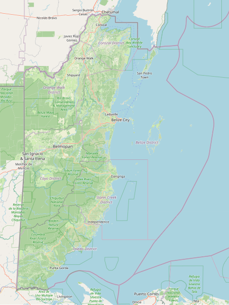
Map of Belize's landcover, major cities, protected areas, etc. Scale 1:1250000. This map of Belize was created from
OpenStreetMap project data, collected by the community. This map may be incomplete, and may contain errors. Don't rely solely on it for navigation. |
|||||||||
| Date | 3 September 2023 | |||||||||
| Source | You may find a page on the OpenStreetMap wiki page for OpenStreetMap Belize map | |||||||||
| Creator |
Dedicated to Charlie Plett, who did the impossible and mapped most of Belize's landuse. OpenStreetMap contributors |
|||||||||
| Permission ( Reusing this file) |
OpenStreetMap data is available under the Open Database License ( details). Standard style map tiles are licensed as ODbL Produced Works.
|
|||||||||
| Geotemporal data | ||||||||||
| Bounding box |
|
|||||||||
| Georeferencing | If inappropriate please set warp_status = skip to hide. | |||||||||
File history
Click on a date/time to view the file as it appeared at that time.
| Date/Time | Thumbnail | Dimensions | User | Comment | |
|---|---|---|---|---|---|
| current | 04:07, 3 September 2023 |
| 899 × 1,196 (17.41 MB) | CactiStaccingCrane | {{OpenStreetMap |name = OpenStreetMap Belize map |location = Belize |description = Map of Belize's landcover, major cities, protected areas, etc. Scale 1:1250000. |top = 18.625424540701264 |bottom = 15.749962572748768 |left = -89.39025878906251 |right = -87.12707519531251 |date = 3 September 2023 |authors = Dedicated to Charlie Plett, who did the impossible and mapped most of Belize's landuse. |other_versions... |
File usage
Global file usage
The following other wikis use this file:
- Usage on sl.wikipedia.org
Metadata
Original file (SVG file, nominally 899 × 1,196 pixels, file size: 17.41 MB)
| This is a file from the
Wikimedia Commons. Information from its
description page there is shown below. Commons is a freely licensed media file repository. You can help. |
Summary
| Description |
Map of Belize's landcover, major cities, protected areas, etc. Scale 1:1250000. This map of Belize was created from
OpenStreetMap project data, collected by the community. This map may be incomplete, and may contain errors. Don't rely solely on it for navigation. |
|||||||||
| Date | 3 September 2023 | |||||||||
| Source | You may find a page on the OpenStreetMap wiki page for OpenStreetMap Belize map | |||||||||
| Creator |
Dedicated to Charlie Plett, who did the impossible and mapped most of Belize's landuse. OpenStreetMap contributors |
|||||||||
| Permission ( Reusing this file) |
OpenStreetMap data is available under the Open Database License ( details). Standard style map tiles are licensed as ODbL Produced Works.
|
|||||||||
| Geotemporal data | ||||||||||
| Bounding box |
|
|||||||||
| Georeferencing | If inappropriate please set warp_status = skip to hide. | |||||||||
File history
Click on a date/time to view the file as it appeared at that time.
| Date/Time | Thumbnail | Dimensions | User | Comment | |
|---|---|---|---|---|---|
| current | 04:07, 3 September 2023 |
| 899 × 1,196 (17.41 MB) | CactiStaccingCrane | {{OpenStreetMap |name = OpenStreetMap Belize map |location = Belize |description = Map of Belize's landcover, major cities, protected areas, etc. Scale 1:1250000. |top = 18.625424540701264 |bottom = 15.749962572748768 |left = -89.39025878906251 |right = -87.12707519531251 |date = 3 September 2023 |authors = Dedicated to Charlie Plett, who did the impossible and mapped most of Belize's landuse. |other_versions... |
File usage
Global file usage
The following other wikis use this file:
- Usage on sl.wikipedia.org