
Original file (SVG file, nominally 692 × 602 pixels, file size: 4.83 MB)
| This is a file from the
Wikimedia Commons. Information from its
description page there is shown below. Commons is a freely licensed media file repository. You can help. |
Summary
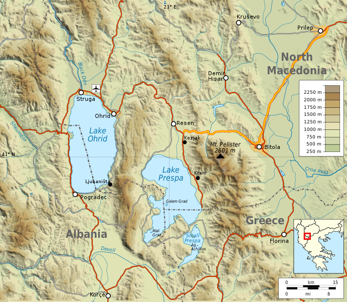
| Description | Topographic map of Lakes Ohrid and Prespa, on the border between Albania, Greece and North Macedonia |
| Date | |
| Source | Own work |
| Author | Future Perfect at Sunrise |
| Other versions |
|
| SVG development |

Area shown: 41°N 21°E / 41°N 21°E +/- c.50 km, scale approx. 1:544,000 at nominal SVG size of 691.5px. Equirectangular projection with true scale at 41°N.
Made with GRASS GIS and Inkscape from public domain data of SRTM3 (elevations), SWBD (lake coast lines) and VMAP0 (roads and rivers), with corrections to roads from Openstreetmap.org (licensed under cc-by-sa 2.0).
Shaded relief is an embedded png bitmap, everything else vectorised in SVG.
Licensing
- You are free:
- to share – to copy, distribute and transmit the work
- to remix – to adapt the work
- Under the following conditions:
- attribution – You must give appropriate credit, provide a link to the license, and indicate if changes were made. You may do so in any reasonable manner, but not in any way that suggests the licensor endorses you or your use.
- share alike – If you remix, transform, or build upon the material, you must distribute your contributions under the same or compatible license as the original.
File history
Click on a date/time to view the file as it appeared at that time.
| Date/Time | Thumbnail | Dimensions | User | Comment | |
|---|---|---|---|---|---|
| current | 07:50, 20 March 2020 |
| 692 × 602 (4.83 MB) | Aris Odi | Name change to "North Macedonia" |
| 09:49, 13 September 2009 |
 | 692 × 602 (4.82 MB) | Future Perfect at Sunrise |
File usage
Global file usage
The following other wikis use this file:
- Usage on az.wikipedia.org
- Usage on bs.wikipedia.org
- Usage on el.wikipedia.org
- Usage on eo.wikipedia.org
- Usage on fa.wikipedia.org
- Usage on fr.wikipedia.org
- Usage on hr.wikipedia.org
- Usage on hu.wikipedia.org
- Usage on id.wikipedia.org
- Usage on incubator.wikimedia.org
- Usage on it.wikipedia.org
- Usage on it.wikivoyage.org
- Usage on ja.wikipedia.org
- Usage on ko.wikipedia.org
- Usage on ku.wikipedia.org
- Usage on la.wikipedia.org
- Usage on mr.wikipedia.org
- Usage on no.wikipedia.org
- Usage on pl.wikipedia.org
- Usage on pl.wiktionary.org
- Usage on pt.wikipedia.org
- Usage on ro.wikipedia.org
- Usage on sh.wikipedia.org
- Usage on simple.wikipedia.org
- Usage on sq.wikipedia.org
- Usage on sq.wikinews.org
- Usage on sr.wikipedia.org
- Usage on sv.wikipedia.org
- Usage on th.wikipedia.org
- Usage on tr.wikipedia.org
- Usage on uk.wikipedia.org
View more global usage of this file.
Metadata
Original file (SVG file, nominally 692 × 602 pixels, file size: 4.83 MB)
| This is a file from the
Wikimedia Commons. Information from its
description page there is shown below. Commons is a freely licensed media file repository. You can help. |
Summary
| Description | Topographic map of Lakes Ohrid and Prespa, on the border between Albania, Greece and North Macedonia |
| Date | |
| Source | Own work |
| Author | Future Perfect at Sunrise |
| Other versions |
|
| SVG development |
Area shown: 41°N 21°E / 41°N 21°E +/- c.50 km, scale approx. 1:544,000 at nominal SVG size of 691.5px. Equirectangular projection with true scale at 41°N.
Made with GRASS GIS and Inkscape from public domain data of SRTM3 (elevations), SWBD (lake coast lines) and VMAP0 (roads and rivers), with corrections to roads from Openstreetmap.org (licensed under cc-by-sa 2.0).
Shaded relief is an embedded png bitmap, everything else vectorised in SVG.
Licensing
- You are free:
- to share – to copy, distribute and transmit the work
- to remix – to adapt the work
- Under the following conditions:
- attribution – You must give appropriate credit, provide a link to the license, and indicate if changes were made. You may do so in any reasonable manner, but not in any way that suggests the licensor endorses you or your use.
- share alike – If you remix, transform, or build upon the material, you must distribute your contributions under the same or compatible license as the original.
File history
Click on a date/time to view the file as it appeared at that time.
| Date/Time | Thumbnail | Dimensions | User | Comment | |
|---|---|---|---|---|---|
| current | 07:50, 20 March 2020 |
| 692 × 602 (4.83 MB) | Aris Odi | Name change to "North Macedonia" |
| 09:49, 13 September 2009 |
| 692 × 602 (4.82 MB) | Future Perfect at Sunrise |
File usage
Global file usage
The following other wikis use this file:
- Usage on az.wikipedia.org
- Usage on bs.wikipedia.org
- Usage on el.wikipedia.org
- Usage on eo.wikipedia.org
- Usage on fa.wikipedia.org
- Usage on fr.wikipedia.org
- Usage on hr.wikipedia.org
- Usage on hu.wikipedia.org
- Usage on id.wikipedia.org
- Usage on incubator.wikimedia.org
- Usage on it.wikipedia.org
- Usage on it.wikivoyage.org
- Usage on ja.wikipedia.org
- Usage on ko.wikipedia.org
- Usage on ku.wikipedia.org
- Usage on la.wikipedia.org
- Usage on mr.wikipedia.org
- Usage on no.wikipedia.org
- Usage on pl.wikipedia.org
- Usage on pl.wiktionary.org
- Usage on pt.wikipedia.org
- Usage on ro.wikipedia.org
- Usage on sh.wikipedia.org
- Usage on simple.wikipedia.org
- Usage on sq.wikipedia.org
- Usage on sq.wikinews.org
- Usage on sr.wikipedia.org
- Usage on sv.wikipedia.org
- Usage on th.wikipedia.org
- Usage on tr.wikipedia.org
- Usage on uk.wikipedia.org
View more global usage of this file.