
Original file (SVG file, nominally 1,000 × 1,000 pixels, file size: 1.01 MB)
| This is a file from the
Wikimedia Commons. Information from its
description page there is shown below. Commons is a freely licensed media file repository. You can help. |
| Description |
Deutsch (de): Amtssprachen in Afrika
Afrikaans Arabisch Englisch Französisch Portugiesisch Spanisch Swahili andere afrikanische Sprachen
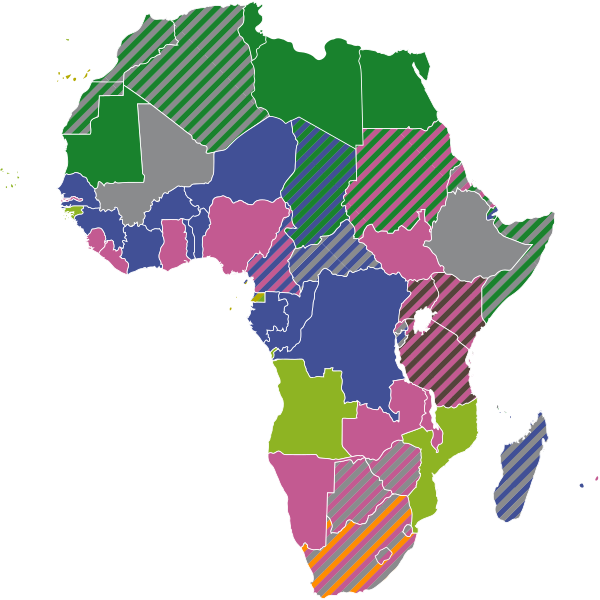
English (en): Official languages in Africa
Afrikaans Arabic English French Portuguese Spanish Swahili other African languages
español (es): Lenguas oficiales en África
Afrikáans Árabe Inglés Francés Portugués Español Suajili Otras lenguas africanas
français (fr): Langues officielles en Afrique
Afrikaans Arabe Anglais Français Portugais Espagnol Swahili autres langues africaines
македонски (mk): Официјални јазици во Африка
африканс арапски англиски француски португалски шпански свахили други африкански јазици
polski (pl): Języki urzędowe w Afryce
Afrikaans Arabski Angielski Francuski Portugalski Hiszpański Suahili inne języki afrykańskie
русский (ru): Официальные языки стран Африки
английский арабский африкаанс испанский португальский суахили французский другие африканские языки
svenska (sv): Officiella språk i Afrika
Afrikaans Arabiska Engelska Franska Portugisiska Spanska Swahili Övriga afrikanska språk
українська (uk): Офіційні мови в країнах Африки
інші
Tiếng Việt (vi): Các ngôn ngữ chính thức tại Phi Châu
Tiếng Afrikaans Tiếng Ả Rập Tiếng Anh Tiếng Pháp Tiếng Bồ Đào Nha Tiếng Tây Ban Nha Tiếng Swahili các ngôn ngữ Phi Châu khác
|
||
| Date | |||
| Source | Own work, using BlankMap-Africa.svg by Lokal Profil | ||
| Author | NordNordWest | ||
| Permission ( Reusing this file) |
|
||
| SVG development | This
map was created with
Adobe Illustrator.
|

File history
Click on a date/time to view the file as it appeared at that time.
| Date/Time | Thumbnail | Dimensions | User | Comment | |
|---|---|---|---|---|---|
| current | 16:01, 25 August 2023 |
| 1,000 × 1,000 (1.01 MB) | NordNordWest | upd Mali |
| 18:44, 22 November 2021 |
 | 1,000 × 1,000 (862 KB) | NordNordWest | corr | |
| 08:04, 7 August 2020 |
 | 1,000 × 1,000 (311 KB) | NordNordWest | corr | |
| 17:52, 7 April 2019 |
 | 1,000 × 1,000 (844 KB) | NordNordWest | corr | |
| 18:59, 16 February 2019 |
 | 1,000 × 1,000 (306 KB) | NordNordWest | corr | |
| 18:16, 21 September 2018 |
 | 1,000 × 1,000 (335 KB) | NordNordWest | corr | |
| 15:35, 27 September 2016 |
 | 1,000 × 1,000 (941 KB) | NordNordWest | corr | |
| 15:29, 27 September 2016 |
 | 1,000 × 1,000 (924 KB) | NordNordWest | corr | |
| 15:24, 27 September 2016 |
 | 1,000 × 1,000 (329 KB) | NordNordWest | upd | |
| 09:23, 12 May 2016 |
 | 1,000 × 1,000 (323 KB) | NordNordWest | corr |
File usage
Global file usage
The following other wikis use this file:
- Usage on af.wikipedia.org
- Usage on an.wikipedia.org
- Usage on ar.wikipedia.org
- Usage on cs.wikipedia.org
- Usage on de.wikipedia.org
- Usage on eo.wikipedia.org
- Usage on es.wikipedia.org
- Usage on fa.wikipedia.org
- Usage on fi.wikipedia.org
- Usage on fr.wikipedia.org
- Usage on he.wikipedia.org
- Usage on it.wikipedia.org
- Usage on ja.wikipedia.org
- Usage on ja.wikibooks.org
- Usage on ka.wikipedia.org
- Usage on ko.wikipedia.org
- Usage on nn.wikipedia.org
- Usage on pl.wikipedia.org
- Usage on pnb.wikipedia.org
- Usage on pt.wikipedia.org
- Usage on ru.wikipedia.org
- Usage on sv.wikipedia.org
- Usage on uk.wikipedia.org
- Usage on ur.wikipedia.org
Metadata
Original file (SVG file, nominally 1,000 × 1,000 pixels, file size: 1.01 MB)
| This is a file from the
Wikimedia Commons. Information from its
description page there is shown below. Commons is a freely licensed media file repository. You can help. |
| Description |
Deutsch (de): Amtssprachen in Afrika
Afrikaans Arabisch Englisch Französisch Portugiesisch Spanisch Swahili andere afrikanische Sprachen
English (en): Official languages in Africa
Afrikaans Arabic English French Portuguese Spanish Swahili other African languages
español (es): Lenguas oficiales en África
Afrikáans Árabe Inglés Francés Portugués Español Suajili Otras lenguas africanas
français (fr): Langues officielles en Afrique
Afrikaans Arabe Anglais Français Portugais Espagnol Swahili autres langues africaines
македонски (mk): Официјални јазици во Африка
африканс арапски англиски француски португалски шпански свахили други африкански јазици
polski (pl): Języki urzędowe w Afryce
Afrikaans Arabski Angielski Francuski Portugalski Hiszpański Suahili inne języki afrykańskie
русский (ru): Официальные языки стран Африки
английский арабский африкаанс испанский португальский суахили французский другие африканские языки
svenska (sv): Officiella språk i Afrika
Afrikaans Arabiska Engelska Franska Portugisiska Spanska Swahili Övriga afrikanska språk
українська (uk): Офіційні мови в країнах Африки
інші
Tiếng Việt (vi): Các ngôn ngữ chính thức tại Phi Châu
Tiếng Afrikaans Tiếng Ả Rập Tiếng Anh Tiếng Pháp Tiếng Bồ Đào Nha Tiếng Tây Ban Nha Tiếng Swahili các ngôn ngữ Phi Châu khác
|
||
| Date | |||
| Source | Own work, using BlankMap-Africa.svg by Lokal Profil | ||
| Author | NordNordWest | ||
| Permission ( Reusing this file) |
|
||
| SVG development | This
map was created with
Adobe Illustrator.
|
File history
Click on a date/time to view the file as it appeared at that time.
| Date/Time | Thumbnail | Dimensions | User | Comment | |
|---|---|---|---|---|---|
| current | 16:01, 25 August 2023 |
| 1,000 × 1,000 (1.01 MB) | NordNordWest | upd Mali |
| 18:44, 22 November 2021 |
| 1,000 × 1,000 (862 KB) | NordNordWest | corr | |
| 08:04, 7 August 2020 |
| 1,000 × 1,000 (311 KB) | NordNordWest | corr | |
| 17:52, 7 April 2019 |
| 1,000 × 1,000 (844 KB) | NordNordWest | corr | |
| 18:59, 16 February 2019 |
| 1,000 × 1,000 (306 KB) | NordNordWest | corr | |
| 18:16, 21 September 2018 |
| 1,000 × 1,000 (335 KB) | NordNordWest | corr | |
| 15:35, 27 September 2016 |
| 1,000 × 1,000 (941 KB) | NordNordWest | corr | |
| 15:29, 27 September 2016 |
| 1,000 × 1,000 (924 KB) | NordNordWest | corr | |
| 15:24, 27 September 2016 |
| 1,000 × 1,000 (329 KB) | NordNordWest | upd | |
| 09:23, 12 May 2016 |
| 1,000 × 1,000 (323 KB) | NordNordWest | corr |
File usage
Global file usage
The following other wikis use this file:
- Usage on af.wikipedia.org
- Usage on an.wikipedia.org
- Usage on ar.wikipedia.org
- Usage on cs.wikipedia.org
- Usage on de.wikipedia.org
- Usage on eo.wikipedia.org
- Usage on es.wikipedia.org
- Usage on fa.wikipedia.org
- Usage on fi.wikipedia.org
- Usage on fr.wikipedia.org
- Usage on he.wikipedia.org
- Usage on it.wikipedia.org
- Usage on ja.wikipedia.org
- Usage on ja.wikibooks.org
- Usage on ka.wikipedia.org
- Usage on ko.wikipedia.org
- Usage on nn.wikipedia.org
- Usage on pl.wikipedia.org
- Usage on pnb.wikipedia.org
- Usage on pt.wikipedia.org
- Usage on ru.wikipedia.org
- Usage on sv.wikipedia.org
- Usage on uk.wikipedia.org
- Usage on ur.wikipedia.org