No higher resolution available.
North_Pacific_Subtropical_Convergence_Zone.jpg (400 × 290 pixels, file size: 104 KB, MIME type: image/jpeg)
| This is a file from the
Wikimedia Commons. Information from its
description page there is shown below. Commons is a freely licensed media file repository. You can help. |


Summary
| Description |
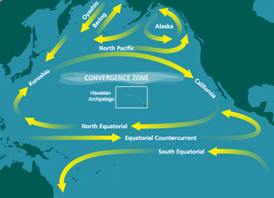
English: Map of the North Pacific Subtropical Convergence Zone (STCZ) within the North Pacific Gyre. Also the location of the Great Pacific Garbage Patch. |
| Date | Unknown date |
| Source | http://marinedebris.noaa.gov/info/patch.html |
| Author | NOAA |
| Permission ( Reusing this file) |
Public domain |
| Other versions | Derivative works of this file: North Pacific Subtropical Convergence Zone-es.png |
Licensing
This image is in the
public domain because it contains materials that originally came from the U.S.
National Oceanic and Atmospheric Administration, taken or made as part of an employee's official duties.
|
File history
Click on a date/time to view the file as it appeared at that time.
| Date/Time | Thumbnail | Dimensions | User | Comment | |
|---|---|---|---|---|---|
| current | 05:10, 29 June 2010 |
| 400 × 290 (104 KB) | Dcoetzee | Remove watermark reading "WWW.MARINEDEBRIS.NOAA.GOV" |
| 07:41, 18 May 2009 |
 | 400 × 290 (107 KB) | Renamed user ixgysjijel | {{Information |Description={{en|1=Map of the North Pacific Subtropical Convergence Zone (STCZ) within the North Pacific Gyre. Also the location of the Great Pacific Garbage Patch.}} |Source=http://marinedebris.noaa.gov/info/patch.html |Author=NOAA |Date= |
File usage
The following pages on the English Wikipedia use this file (pages on other projects are not listed):
- Boundary current
- Ecosystem of the North Pacific Subtropical Gyre
- Great Pacific garbage patch
- High-nutrient, low-chlorophyll regions
- Marine plastic pollution
- Maritime history of California
- North Pacific Gyre
- Thomas Cavendish
- Thomas Cavendish's circumnavigation
- United Nations Ocean Conference
- User:Horn.kali/sandbox
- User:Vanisheduser431890/sandbox
Global file usage
The following other wikis use this file:
- Usage on ar.wikipedia.org
- Usage on ca.wikipedia.org
- Usage on da.wikipedia.org
- Usage on en.wikiversity.org
- Usage on es.wikipedia.org
- Usage on fa.wikipedia.org
- Usage on fr.wikipedia.org
- Usage on he.wikipedia.org
- Usage on id.wikipedia.org
- Usage on ig.wikipedia.org
- Usage on it.wikipedia.org
- Usage on ja.wikipedia.org
- Usage on ko.wikipedia.org
- Usage on krc.wikipedia.org
- Usage on mdf.wikipedia.org
- Usage on nl.wikipedia.org
- Usage on pl.wikipedia.org
- Usage on pt.wikipedia.org
- Usage on ru.wikipedia.org
- Usage on simple.wikipedia.org
- Usage on sl.wikipedia.org
- Usage on sv.wikipedia.org
- Usage on th.wikipedia.org
- Usage on uk.wikipedia.org
- Usage on vi.wikipedia.org
- Usage on www.wikidata.org
- Usage on zh.wikipedia.org
Metadata
No higher resolution available.
North_Pacific_Subtropical_Convergence_Zone.jpg (400 × 290 pixels, file size: 104 KB, MIME type: image/jpeg)
| This is a file from the
Wikimedia Commons. Information from its
description page there is shown below. Commons is a freely licensed media file repository. You can help. |
Summary
| Description |
English: Map of the North Pacific Subtropical Convergence Zone (STCZ) within the North Pacific Gyre. Also the location of the Great Pacific Garbage Patch. |
| Date | Unknown date |
| Source | http://marinedebris.noaa.gov/info/patch.html |
| Author | NOAA |
| Permission ( Reusing this file) |
Public domain |
| Other versions | Derivative works of this file: North Pacific Subtropical Convergence Zone-es.png |
Licensing
This image is in the
public domain because it contains materials that originally came from the U.S.
National Oceanic and Atmospheric Administration, taken or made as part of an employee's official duties.
|
File history
Click on a date/time to view the file as it appeared at that time.
| Date/Time | Thumbnail | Dimensions | User | Comment | |
|---|---|---|---|---|---|
| current | 05:10, 29 June 2010 |
| 400 × 290 (104 KB) | Dcoetzee | Remove watermark reading "WWW.MARINEDEBRIS.NOAA.GOV" |
| 07:41, 18 May 2009 |
| 400 × 290 (107 KB) | Renamed user ixgysjijel | {{Information |Description={{en|1=Map of the North Pacific Subtropical Convergence Zone (STCZ) within the North Pacific Gyre. Also the location of the Great Pacific Garbage Patch.}} |Source=http://marinedebris.noaa.gov/info/patch.html |Author=NOAA |Date= |
File usage
The following pages on the English Wikipedia use this file (pages on other projects are not listed):
- Boundary current
- Ecosystem of the North Pacific Subtropical Gyre
- Great Pacific garbage patch
- High-nutrient, low-chlorophyll regions
- Marine plastic pollution
- Maritime history of California
- North Pacific Gyre
- Thomas Cavendish
- Thomas Cavendish's circumnavigation
- United Nations Ocean Conference
- User:Horn.kali/sandbox
- User:Vanisheduser431890/sandbox
Global file usage
The following other wikis use this file:
- Usage on ar.wikipedia.org
- Usage on ca.wikipedia.org
- Usage on da.wikipedia.org
- Usage on en.wikiversity.org
- Usage on es.wikipedia.org
- Usage on fa.wikipedia.org
- Usage on fr.wikipedia.org
- Usage on he.wikipedia.org
- Usage on id.wikipedia.org
- Usage on ig.wikipedia.org
- Usage on it.wikipedia.org
- Usage on ja.wikipedia.org
- Usage on ko.wikipedia.org
- Usage on krc.wikipedia.org
- Usage on mdf.wikipedia.org
- Usage on nl.wikipedia.org
- Usage on pl.wikipedia.org
- Usage on pt.wikipedia.org
- Usage on ru.wikipedia.org
- Usage on simple.wikipedia.org
- Usage on sl.wikipedia.org
- Usage on sv.wikipedia.org
- Usage on th.wikipedia.org
- Usage on uk.wikipedia.org
- Usage on vi.wikipedia.org
- Usage on www.wikidata.org
- Usage on zh.wikipedia.org