
Size of this PNG preview of this SVG file:
800 × 422 pixels. Other resolutions:
320 × 169 pixels |
640 × 338 pixels |
1,024 × 540 pixels |
1,280 × 676 pixels |
2,560 × 1,351 pixels |
3,240 × 1,710 pixels.
Original file (SVG file, nominally 3,240 × 1,710 pixels, file size: 16.32 MB)
| This is a file from the
Wikimedia Commons. Information from its
description page there is shown below. Commons is a freely licensed media file repository. You can help. |
.svg)
Summary
| Description |
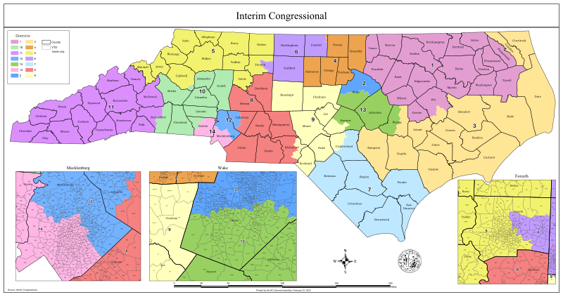
English: The remedial congressional district maps of North Carolina drawn on February 23, 2022 by a panel chosen by the Wake County Superior Court (NCLCV, et al. v. Hall, et al. and Harper, et al. v. Hall, et al.) to be used in the 2022 House elections |
| Date | |
| Source | https://www.ncleg.gov/Redistricting |
| Author | NC General Assembly |
Licensing
| This map is ineligible for
copyright and therefore in the
public domain, because it consists entirely of information that is common property and contains no original authorship. For more information, see
Commons:Threshold of originality § Maps.
|
File history
Click on a date/time to view the file as it appeared at that time.
| Date/Time | Thumbnail | Dimensions | User | Comment | |
|---|---|---|---|---|---|
| current | 09:24, 24 February 2022 |
| 3,240 × 1,710 (16.32 MB) | Twotwofourtysix | Uploaded a work by NC General Assembly from https://www.ncleg.gov/Redistricting with UploadWizard |
File usage
The following pages on the English Wikipedia use this file (pages on other projects are not listed):
Global file usage
The following other wikis use this file:
- Usage on it.wikipedia.org
- Usage on ja.wikipedia.org
- Usage on simple.wikipedia.org
Metadata
.svg)
Size of this PNG preview of this SVG file:
800 × 422 pixels. Other resolutions:
320 × 169 pixels |
640 × 338 pixels |
1,024 × 540 pixels |
1,280 × 676 pixels |
2,560 × 1,351 pixels |
3,240 × 1,710 pixels.
Original file (SVG file, nominally 3,240 × 1,710 pixels, file size: 16.32 MB)
| This is a file from the
Wikimedia Commons. Information from its
description page there is shown below. Commons is a freely licensed media file repository. You can help. |
Summary
| Description |
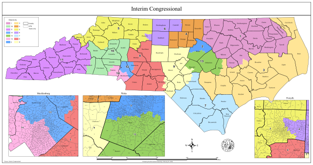
English: The remedial congressional district maps of North Carolina drawn on February 23, 2022 by a panel chosen by the Wake County Superior Court (NCLCV, et al. v. Hall, et al. and Harper, et al. v. Hall, et al.) to be used in the 2022 House elections |
| Date | |
| Source | https://www.ncleg.gov/Redistricting |
| Author | NC General Assembly |
Licensing
| This map is ineligible for
copyright and therefore in the
public domain, because it consists entirely of information that is common property and contains no original authorship. For more information, see
Commons:Threshold of originality § Maps.
|
File history
Click on a date/time to view the file as it appeared at that time.
| Date/Time | Thumbnail | Dimensions | User | Comment | |
|---|---|---|---|---|---|
| current | 09:24, 24 February 2022 |
| 3,240 × 1,710 (16.32 MB) | Twotwofourtysix | Uploaded a work by NC General Assembly from https://www.ncleg.gov/Redistricting with UploadWizard |
File usage
The following pages on the English Wikipedia use this file (pages on other projects are not listed):
Global file usage
The following other wikis use this file:
- Usage on it.wikipedia.org
- Usage on ja.wikipedia.org
- Usage on simple.wikipedia.org