
Original file (1,549 × 704 pixels, file size: 97 KB, MIME type: image/png)
| This is a file from the
Wikimedia Commons. Information from its
description page there is shown below. Commons is a freely licensed media file repository. You can help. |
Summary
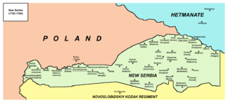
- English: Map of New Serbia, a territory of Imperial Russia from 1752 to 1764.
- Српски / srpski: Mapa Nove Srbije, teritorije Ruskog carstva, između 1752. i 1764. godine.
- Русский: Карта Новой Сербии в момент создания на территории Российской империи (граничит с Польшей и Гетманщиной). Между 1752 и 1764 годами.
Source and licence
Self-made map by PANONIAN
| This work has been released into the
public domain by its author,
PANONIAN. This applies worldwide. In some countries this may not be legally possible; if so: |
References
- Mita Kostić, Nova Srbija i Slavenosrbija, Novi Sad, 2001.
- Olga M. Posunjko, Istorija Nove Srbije i Slavenosrbije, Novi Sad, 2002.
- Pavel Rudjakov, Seoba Srba u Rusiju u 18. veku, Beograd, 1995.
- http://www.rastko.rs/rastko-ukr/istorija/img/nova_serbija.jpg
- http://www.irekw.internetdsl.pl/27_1727-1768.jpg archive copy at the Wayback Machine
- http://www.jewishgen.org/Ukraine/maps/Ukrainian-Land-1750.jpg
Place names
| Older Ukrainian/Russian name (1.) | Serbian name from the middle of the 18th century | Ukrainian/Russian name from the middle of the 18th century (1.) | Newer or modern Ukrainian/Russian name (1.) |
|---|---|---|---|
| Skaleva | Semlak (2.) | Semlik | Skaleva |
| - | Novoarhangelsk / Arhangelsk | Novoarkhangelsk / Novoarkhangelysk | Novoarkhangelsk / Novoarkhangelysk |
| Ganivka | Kalniblat / Kalnibolot | Kalnibolot / Kalynibolot | Kalynibolota |
| - | Nadlak (2.) | Nadlak | Nadlak |
| Davidivka | Petrovo Ostrovo / Petro-Ostrov (2.) | Petroostriv | Petroostriv |
| Korobchino | Pečka (2.) | Bechka | Korobchine |
| Trisyaga | Novomirgorod / Novi Mirgorod | Novomirgorod | Novomyrhorod / Novomirgorod |
| Yermina Balka | Martonoš (2.) | Martonosh | Martonosha |
| Olykhovatka | Pančevo (2.) | Panchevo | Pancheve |
| Tri Bayraki | Kanjiža (2.) | Kanizh | Kanizh |
| Mogilovo | Senta (2.) | Senta | Mogiliv / Rodnikivka |
| - | Vukovar (2.) | Vukovar | Bukvarka |
| - | Feldvar / Fedvar (2.) | Fedvar | Pidlisne |
| Mala Adzhamka | Subotica (2.) | Subotitsa | Subottsi |
| Nekrasivska | Mošorin (2.) | Moshorin | Moshorine |
| - | Cibuljev / Cibulev | Tsibuliv | Tsibuleve |
| - | Dmitrovka | Dmitrivka | Dmitrivka |
| Dikivka | Sombor (2.) | Sombor | Dikivka |
| Protopopivka | Varaždin (2.) | Varazhdin | Protopopivka |
| Usikivka | Bečej (2.) | Becha | Usikivka / Oleksandriya |
| - | Glinsk | Glinsk | Glinsk |
| Pantaziyivka | Jenova | Yaniv | Ivanivka |
| - | Mandorlak (2.) | Mandorlak | - |
| Kosivka | Glogovac (2.) | Glogovats | Kosivka |
| Butivka | Pavliš (2.) | Pavlish | Pavlish |
| - | Piljužnica | Pilazhnitsa | - |
| Onufriyivka | Blagovat | Blagovat | Onufriyivka |
| - | Sentomaš (2.) | Sentomash | - |
| - | Kovin (2.) | Kovin | - |
| - | Čanad (2.) | Chonad | - |
| - | Slankamen (2.) | Slankamin | - |
| Nesterivka | Vršac (2.) | Vershats | Vershatsi |
| Stetsivka | Šoljmoš / Šolmoš (2.) | Sholmosh | Stetsivka |
| Andrusivka | Čongrad (2.) | Chongrad | Velika Andrusivka |
| - | Krilov | Kriliv | Kriliv |
| - | Taburište / Taburino | Taburishche | Svitlovodsk |
| - | Krjukov | Kryukiv | Kryukiv |
| - | Kamjanka / Kamenka | Kamyanka | Kamyani Potoki |
| Plakhtiyivka | Zemun (2.) | Zemun | Uspenka |
| Deriyivka | Vilagoš (2.) | Vilagosh | Deriyivka |
| - | Turija (2.) (3.) | Turiya | Turiya |
Notes:
- (1.) Ukrainian and Russian names are given in Latin script transliterations.
- (2.) These names were brought by Serbs from their old homeland in southern Pannonian Plain. Places with same names are also existing (or existed) in modern-day Serbia (Vojvodina), Croatia, Romania and Hungary.
- (3.) Serb settlement of Turiya (Turija) was located in what sources are describing as a nominal Polish territory. The border between New Serbia and Poland was, however, often disputed and unstable.
File history
Click on a date/time to view the file as it appeared at that time.
| Date/Time | Thumbnail | Dimensions | User | Comment | |
|---|---|---|---|---|---|
| current | 10:05, 1 October 2013 |
| 1,549 × 704 (97 KB) | PANONIAN | aesthetics |
| 14:30, 2 May 2010 |
 | 1,549 × 707 (97 KB) | PANONIAN | name correction | |
| 19:11, 1 May 2010 |
 | 1,549 × 707 (96 KB) | PANONIAN | corrected some names | |
| 12:12, 26 April 2010 |
 | 1,549 × 707 (93 KB) | PANONIAN | improved version | |
| 01:19, 19 March 2009 |
| 945 × 325 (27 KB) | PANONIAN | Map of New Serbia, a territory of Imperial Russia from 1752 to 1764. Self-made map by PANONIAN {{PD-user|PANONIAN}} Category:Maps of the history of Serbia Category:Maps of the history of Ukraine [[Category:Maps of the history of |
File usage
Global file usage
The following other wikis use this file:
- Usage on cs.wikipedia.org
- Usage on de.wikipedia.org
- Usage on el.wikipedia.org
- Usage on fr.wikipedia.org
- Usage on he.wikipedia.org
- Usage on hr.wikipedia.org
- Usage on lv.wikipedia.org
- Usage on mn.wikipedia.org
- Usage on nl.wikipedia.org
- Usage on pl.wikipedia.org
- Usage on sh.wikipedia.org
- Usage on uk.wikipedia.org
- Новоархангельський район
- Нова Сербія
- Користувач:Alex Blokha/Події в Вікіпедії/29 грудня
- Користувач:Alex Blokha/Події в Вікіпедії/11 березня
- Користувач:Alex Blokha/Події в Вікіпедії/22 березня
- Користувач:Alex Blokha/Події в Вікіпедії/26 березня
- Користувач:Alex Blokha/Події в Вікіпедії/14 травня
- Новомиргород
- Новоархангельськ
- Історія Новомиргорода
- Користувач:Alex Blokha/Дні згадані в Вікіпедії/Україна/29 грудня
- Користувач:Alex Blokha/Дні згадані в Вікіпедії/Україна/11 березня
- Користувач:Alex Blokha/Дні згадані в Вікіпедії/Україна/22 березня
- Користувач:Alex Blokha/Дні згадані в Вікіпедії/Україна/26 березня
- Користувач:Alex Blokha/Дні згадані в Вікіпедії/Україна/14 травня
- Usage on uz.wikipedia.org
- Usage on vi.wikipedia.org
Original file (1,549 × 704 pixels, file size: 97 KB, MIME type: image/png)
| This is a file from the
Wikimedia Commons. Information from its
description page there is shown below. Commons is a freely licensed media file repository. You can help. |
Summary
- English: Map of New Serbia, a territory of Imperial Russia from 1752 to 1764.
- Српски / srpski: Mapa Nove Srbije, teritorije Ruskog carstva, između 1752. i 1764. godine.
- Русский: Карта Новой Сербии в момент создания на территории Российской империи (граничит с Польшей и Гетманщиной). Между 1752 и 1764 годами.
Source and licence
Self-made map by PANONIAN
| This work has been released into the
public domain by its author,
PANONIAN. This applies worldwide. In some countries this may not be legally possible; if so: |
References
- Mita Kostić, Nova Srbija i Slavenosrbija, Novi Sad, 2001.
- Olga M. Posunjko, Istorija Nove Srbije i Slavenosrbije, Novi Sad, 2002.
- Pavel Rudjakov, Seoba Srba u Rusiju u 18. veku, Beograd, 1995.
- http://www.rastko.rs/rastko-ukr/istorija/img/nova_serbija.jpg
- http://www.irekw.internetdsl.pl/27_1727-1768.jpg archive copy at the Wayback Machine
- http://www.jewishgen.org/Ukraine/maps/Ukrainian-Land-1750.jpg
Place names
| Older Ukrainian/Russian name (1.) | Serbian name from the middle of the 18th century | Ukrainian/Russian name from the middle of the 18th century (1.) | Newer or modern Ukrainian/Russian name (1.) |
|---|---|---|---|
| Skaleva | Semlak (2.) | Semlik | Skaleva |
| - | Novoarhangelsk / Arhangelsk | Novoarkhangelsk / Novoarkhangelysk | Novoarkhangelsk / Novoarkhangelysk |
| Ganivka | Kalniblat / Kalnibolot | Kalnibolot / Kalynibolot | Kalynibolota |
| - | Nadlak (2.) | Nadlak | Nadlak |
| Davidivka | Petrovo Ostrovo / Petro-Ostrov (2.) | Petroostriv | Petroostriv |
| Korobchino | Pečka (2.) | Bechka | Korobchine |
| Trisyaga | Novomirgorod / Novi Mirgorod | Novomirgorod | Novomyrhorod / Novomirgorod |
| Yermina Balka | Martonoš (2.) | Martonosh | Martonosha |
| Olykhovatka | Pančevo (2.) | Panchevo | Pancheve |
| Tri Bayraki | Kanjiža (2.) | Kanizh | Kanizh |
| Mogilovo | Senta (2.) | Senta | Mogiliv / Rodnikivka |
| - | Vukovar (2.) | Vukovar | Bukvarka |
| - | Feldvar / Fedvar (2.) | Fedvar | Pidlisne |
| Mala Adzhamka | Subotica (2.) | Subotitsa | Subottsi |
| Nekrasivska | Mošorin (2.) | Moshorin | Moshorine |
| - | Cibuljev / Cibulev | Tsibuliv | Tsibuleve |
| - | Dmitrovka | Dmitrivka | Dmitrivka |
| Dikivka | Sombor (2.) | Sombor | Dikivka |
| Protopopivka | Varaždin (2.) | Varazhdin | Protopopivka |
| Usikivka | Bečej (2.) | Becha | Usikivka / Oleksandriya |
| - | Glinsk | Glinsk | Glinsk |
| Pantaziyivka | Jenova | Yaniv | Ivanivka |
| - | Mandorlak (2.) | Mandorlak | - |
| Kosivka | Glogovac (2.) | Glogovats | Kosivka |
| Butivka | Pavliš (2.) | Pavlish | Pavlish |
| - | Piljužnica | Pilazhnitsa | - |
| Onufriyivka | Blagovat | Blagovat | Onufriyivka |
| - | Sentomaš (2.) | Sentomash | - |
| - | Kovin (2.) | Kovin | - |
| - | Čanad (2.) | Chonad | - |
| - | Slankamen (2.) | Slankamin | - |
| Nesterivka | Vršac (2.) | Vershats | Vershatsi |
| Stetsivka | Šoljmoš / Šolmoš (2.) | Sholmosh | Stetsivka |
| Andrusivka | Čongrad (2.) | Chongrad | Velika Andrusivka |
| - | Krilov | Kriliv | Kriliv |
| - | Taburište / Taburino | Taburishche | Svitlovodsk |
| - | Krjukov | Kryukiv | Kryukiv |
| - | Kamjanka / Kamenka | Kamyanka | Kamyani Potoki |
| Plakhtiyivka | Zemun (2.) | Zemun | Uspenka |
| Deriyivka | Vilagoš (2.) | Vilagosh | Deriyivka |
| - | Turija (2.) (3.) | Turiya | Turiya |
Notes:
- (1.) Ukrainian and Russian names are given in Latin script transliterations.
- (2.) These names were brought by Serbs from their old homeland in southern Pannonian Plain. Places with same names are also existing (or existed) in modern-day Serbia (Vojvodina), Croatia, Romania and Hungary.
- (3.) Serb settlement of Turiya (Turija) was located in what sources are describing as a nominal Polish territory. The border between New Serbia and Poland was, however, often disputed and unstable.
File history
Click on a date/time to view the file as it appeared at that time.
| Date/Time | Thumbnail | Dimensions | User | Comment | |
|---|---|---|---|---|---|
| current | 10:05, 1 October 2013 |
| 1,549 × 704 (97 KB) | PANONIAN | aesthetics |
| 14:30, 2 May 2010 |
| 1,549 × 707 (97 KB) | PANONIAN | name correction | |
| 19:11, 1 May 2010 |
| 1,549 × 707 (96 KB) | PANONIAN | corrected some names | |
| 12:12, 26 April 2010 |
| 1,549 × 707 (93 KB) | PANONIAN | improved version | |
| 01:19, 19 March 2009 |
| 945 × 325 (27 KB) | PANONIAN | Map of New Serbia, a territory of Imperial Russia from 1752 to 1764. Self-made map by PANONIAN {{PD-user|PANONIAN}} Category:Maps of the history of Serbia Category:Maps of the history of Ukraine [[Category:Maps of the history of |
File usage
Global file usage
The following other wikis use this file:
- Usage on cs.wikipedia.org
- Usage on de.wikipedia.org
- Usage on el.wikipedia.org
- Usage on fr.wikipedia.org
- Usage on he.wikipedia.org
- Usage on hr.wikipedia.org
- Usage on lv.wikipedia.org
- Usage on mn.wikipedia.org
- Usage on nl.wikipedia.org
- Usage on pl.wikipedia.org
- Usage on sh.wikipedia.org
- Usage on uk.wikipedia.org
- Новоархангельський район
- Нова Сербія
- Користувач:Alex Blokha/Події в Вікіпедії/29 грудня
- Користувач:Alex Blokha/Події в Вікіпедії/11 березня
- Користувач:Alex Blokha/Події в Вікіпедії/22 березня
- Користувач:Alex Blokha/Події в Вікіпедії/26 березня
- Користувач:Alex Blokha/Події в Вікіпедії/14 травня
- Новомиргород
- Новоархангельськ
- Історія Новомиргорода
- Користувач:Alex Blokha/Дні згадані в Вікіпедії/Україна/29 грудня
- Користувач:Alex Blokha/Дні згадані в Вікіпедії/Україна/11 березня
- Користувач:Alex Blokha/Дні згадані в Вікіпедії/Україна/22 березня
- Користувач:Alex Blokha/Дні згадані в Вікіпедії/Україна/26 березня
- Користувач:Alex Blokha/Дні згадані в Вікіпедії/Україна/14 травня
- Usage on uz.wikipedia.org
- Usage on vi.wikipedia.org