No higher resolution available.
Nepkoztarsasag.png (660 × 428 pixels, file size: 55 KB, MIME type: image/png)
| This is a file from the
Wikimedia Commons. Information from its
description page there is shown below. Commons is a freely licensed media file repository. You can help. |
Accuracy
Summary
| Description |
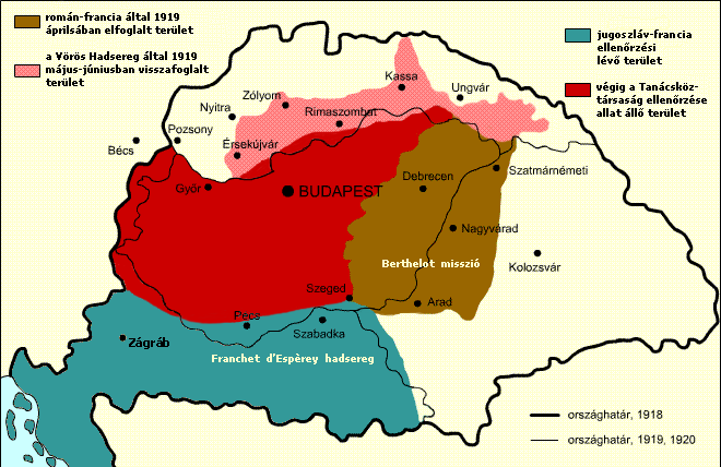
English: Military success of the Hungarian Soviet Republic Territory under Romanian and French control in April, 1919 Territory under the control of the
Hungarian Soviet Republic Territory recovered by the Hungarian Soviet Republic Territory under French and Yugoslav control
Italiano: Situazione territoriale della Repubblica sovietica ungherese Territori sotto il controllo rumeno e francese nell'aprile 1919 Territori sotto il controllo della
Repubblica sovietica ungherese Territori riconquistati dalla Repubblica sovietica ungherese Territori sotto il controllo francese e jugoslavo
Español: Situación territorial durante el periodo de la República Soviética Húngara Territorio bajo control rumano-francés en abril de 1919. Territorio originalmente bajo control de la
República Soviética Húngara Territorio recuperado por la República a Checoslovaquia Territorio bajo control franco-yugoslavo |
| Date | |
| Source |
Transferred from
hu.wikipedia to Commons. The original description page was
here. All following user names refer to hu.wikipedia. |
| Author | Kovács Ádám |
| Other versions | Derivative works of this file: RepúblicaSoviéticaHúngara1919.svg; Georgian Version SVG |
Licensing
This file is licensed under the
Creative Commons
Attribution-Share Alike 2.5 Generic license.
- You are free:
- to share – to copy, distribute and transmit the work
- to remix – to adapt the work
- Under the following conditions:
- attribution – You must give appropriate credit, provide a link to the license, and indicate if changes were made. You may do so in any reasonable manner, but not in any way that suggests the licensor endorses you or your use.
- share alike – If you remix, transform, or build upon the material, you must distribute your contributions under the same or compatible license as the original.
File history
Click on a date/time to view the file as it appeared at that time.
| Date/Time | Thumbnail | Dimensions | User | Comment | |
|---|---|---|---|---|---|
| current | 13:15, 22 November 2017 |
| 660 × 428 (55 KB) | Julieta39 | Diacritic corrected |
| 12:04, 22 November 2017 |
 | 660 × 428 (55 KB) | Julieta39 | According with "Történelmi atlasz", Kartográfiai Vállalat, Budapest 1989, ISBN 9633514223 CM | |
| 11:08, 9 February 2011 |
 | 660 × 428 (47 KB) | Hobartimus~commonswiki | Reverted to version as of 18:15, 6 February 2011 | |
| 00:20, 9 February 2011 |
 | 660 × 428 (23 KB) | Lovech~commonswiki | returning to the superior original version | |
| 18:15, 6 February 2011 |
 | 660 × 428 (47 KB) | 123iti | reverted unexplained edit | |
| 16:40, 5 February 2011 |
 | 660 × 428 (23 KB) | Lovech~commonswiki | Reverted to version as of 22:33, 28 December 2010 | |
| 00:17, 29 December 2010 |
 | 660 × 428 (47 KB) | 123iti | ok, then I am proposing this compromise version due to my discussion page explanation | |
| 22:33, 28 December 2010 |
 | 660 × 428 (23 KB) | VT | Reverted to version as of 13:20, 20 May 2009 -> this version is right, then those territories were under occupation | |
| 11:53, 6 December 2010 |
 | 660 × 428 (35 KB) | 123iti | There is no reason that vojvodina is colored here because it had no any relation with Hungarian Soviet Republic. See source: http://libcom.org/files/images/library/hungarianmap%5B1%5D.jpg (Transylvania, Slovakia and Transcarpathia are not colored too, so | |
| 13:20, 20 May 2009 |
 | 660 × 428 (23 KB) | Baxter9~commonswiki | {{Information |Description={{en|1=Military succes of the Hungarian Soviet Republic}} |Source=http://hu.wikipedia.org/wiki/F%C3%A1jl:Nepkoztarsasag.png |Author=Kovács Ádám |Date=2006 |Permission= |other_versions= }} <!--{{ImageUpload|full}}--> [[Catego |
File usage
The following pages on the English Wikipedia use this file (pages on other projects are not listed):
Global file usage
The following other wikis use this file:
- Usage on ar.wikipedia.org
- Usage on ast.wikipedia.org
- Usage on azb.wikipedia.org
- Usage on az.wikipedia.org
- Usage on be.wikipedia.org
- Usage on bg.wikipedia.org
- Usage on cbk-zam.wikipedia.org
- Usage on cs.wikipedia.org
- Usage on da.wikipedia.org
- Usage on el.wikipedia.org
- Usage on eo.wikipedia.org
- Usage on et.wikipedia.org
- Usage on eu.wikipedia.org
- Usage on fa.wikipedia.org
- Usage on fr.wikipedia.org
- Usage on gl.wikipedia.org
- Usage on hr.wikipedia.org
- Usage on hu.wikipedia.org
- Usage on hy.wikipedia.org
- Usage on id.wikipedia.org
- Usage on it.wikipedia.org
- Usage on ja.wikipedia.org
- Usage on ka.wikipedia.org
- Usage on kk.wikipedia.org
- Usage on ko.wikipedia.org
- Usage on la.wikipedia.org
- Usage on lv.wikipedia.org
- Usage on mk.wikipedia.org
- Usage on pl.wikipedia.org
View more global usage of this file.
Metadata
No higher resolution available.
Nepkoztarsasag.png (660 × 428 pixels, file size: 55 KB, MIME type: image/png)
| This is a file from the
Wikimedia Commons. Information from its
description page there is shown below. Commons is a freely licensed media file repository. You can help. |
Accuracy
Summary
| Description |
English: Military success of the Hungarian Soviet Republic Territory under Romanian and French control in April, 1919 Territory under the control of the
Hungarian Soviet Republic Territory recovered by the Hungarian Soviet Republic Territory under French and Yugoslav control
Italiano: Situazione territoriale della Repubblica sovietica ungherese Territori sotto il controllo rumeno e francese nell'aprile 1919 Territori sotto il controllo della
Repubblica sovietica ungherese Territori riconquistati dalla Repubblica sovietica ungherese Territori sotto il controllo francese e jugoslavo
Español: Situación territorial durante el periodo de la República Soviética Húngara Territorio bajo control rumano-francés en abril de 1919. Territorio originalmente bajo control de la
República Soviética Húngara Territorio recuperado por la República a Checoslovaquia Territorio bajo control franco-yugoslavo |
| Date | |
| Source |
Transferred from
hu.wikipedia to Commons. The original description page was
here. All following user names refer to hu.wikipedia. |
| Author | Kovács Ádám |
| Other versions | Derivative works of this file: RepúblicaSoviéticaHúngara1919.svg; Georgian Version SVG |
Licensing
This file is licensed under the
Creative Commons
Attribution-Share Alike 2.5 Generic license.
- You are free:
- to share – to copy, distribute and transmit the work
- to remix – to adapt the work
- Under the following conditions:
- attribution – You must give appropriate credit, provide a link to the license, and indicate if changes were made. You may do so in any reasonable manner, but not in any way that suggests the licensor endorses you or your use.
- share alike – If you remix, transform, or build upon the material, you must distribute your contributions under the same or compatible license as the original.
File history
Click on a date/time to view the file as it appeared at that time.
| Date/Time | Thumbnail | Dimensions | User | Comment | |
|---|---|---|---|---|---|
| current | 13:15, 22 November 2017 |
| 660 × 428 (55 KB) | Julieta39 | Diacritic corrected |
| 12:04, 22 November 2017 |
| 660 × 428 (55 KB) | Julieta39 | According with "Történelmi atlasz", Kartográfiai Vállalat, Budapest 1989, ISBN 9633514223 CM | |
| 11:08, 9 February 2011 |
| 660 × 428 (47 KB) | Hobartimus~commonswiki | Reverted to version as of 18:15, 6 February 2011 | |
| 00:20, 9 February 2011 |
| 660 × 428 (23 KB) | Lovech~commonswiki | returning to the superior original version | |
| 18:15, 6 February 2011 |
| 660 × 428 (47 KB) | 123iti | reverted unexplained edit | |
| 16:40, 5 February 2011 |
| 660 × 428 (23 KB) | Lovech~commonswiki | Reverted to version as of 22:33, 28 December 2010 | |
| 00:17, 29 December 2010 |
| 660 × 428 (47 KB) | 123iti | ok, then I am proposing this compromise version due to my discussion page explanation | |
| 22:33, 28 December 2010 |
| 660 × 428 (23 KB) | VT | Reverted to version as of 13:20, 20 May 2009 -> this version is right, then those territories were under occupation | |
| 11:53, 6 December 2010 |
| 660 × 428 (35 KB) | 123iti | There is no reason that vojvodina is colored here because it had no any relation with Hungarian Soviet Republic. See source: http://libcom.org/files/images/library/hungarianmap%5B1%5D.jpg (Transylvania, Slovakia and Transcarpathia are not colored too, so | |
| 13:20, 20 May 2009 |
| 660 × 428 (23 KB) | Baxter9~commonswiki | {{Information |Description={{en|1=Military succes of the Hungarian Soviet Republic}} |Source=http://hu.wikipedia.org/wiki/F%C3%A1jl:Nepkoztarsasag.png |Author=Kovács Ádám |Date=2006 |Permission= |other_versions= }} <!--{{ImageUpload|full}}--> [[Catego |
File usage
The following pages on the English Wikipedia use this file (pages on other projects are not listed):
Global file usage
The following other wikis use this file:
- Usage on ar.wikipedia.org
- Usage on ast.wikipedia.org
- Usage on azb.wikipedia.org
- Usage on az.wikipedia.org
- Usage on be.wikipedia.org
- Usage on bg.wikipedia.org
- Usage on cbk-zam.wikipedia.org
- Usage on cs.wikipedia.org
- Usage on da.wikipedia.org
- Usage on el.wikipedia.org
- Usage on eo.wikipedia.org
- Usage on et.wikipedia.org
- Usage on eu.wikipedia.org
- Usage on fa.wikipedia.org
- Usage on fr.wikipedia.org
- Usage on gl.wikipedia.org
- Usage on hr.wikipedia.org
- Usage on hu.wikipedia.org
- Usage on hy.wikipedia.org
- Usage on id.wikipedia.org
- Usage on it.wikipedia.org
- Usage on ja.wikipedia.org
- Usage on ka.wikipedia.org
- Usage on kk.wikipedia.org
- Usage on ko.wikipedia.org
- Usage on la.wikipedia.org
- Usage on lv.wikipedia.org
- Usage on mk.wikipedia.org
- Usage on pl.wikipedia.org
View more global usage of this file.