National-atlas-general-reference-map-USA.png (735 × 495 pixels, file size: 138 KB, MIME type: image/png)
| This is a file from the
Wikimedia Commons. Information from its
description page there is shown below. Commons is a freely licensed media file repository. You can help. |
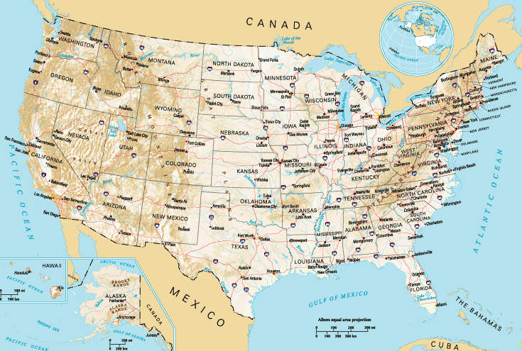
Transwiki approved by: w:en:User:Dmcdevit This image was copied from wikipedia:en. The original description was:
This map was obtained from an edition of the
National Atlas of the United States. Like almost all works of the U.S. federal government, works from the National Atlas are in the
public domain in the United States.
Online access: NationalAtlas.gov | 1970 print edition: Library of Congress, Perry-Castañeda Library
|
w:en:Category:United States maps w:en:vi:Image:National-atlas-general-reference-map-USA.png
Original upload log
| date/time | username | resolution | size | edit summary |
|---|---|---|---|---|
| 05:53, 6 December 2004 | w:en:User:Berkut | 765×585 | 137 KB | optimized pngrewrite+pngout |
| 20:51, 13 October 2004 | w:en:User:Jengod | 765×585 | 411 KB | {{PD}} |
Image description page history
File history
Click on a date/time to view the file as it appeared at that time.
| Date/Time | Thumbnail | Dimensions | User | Comment | |
|---|---|---|---|---|---|
| current | 17:15, 28 September 2023 |
| 735 × 495 (138 KB) | Beao | Cropped 4 % horizontally, 15 % vertically using CropTool with lossless mode. Removed watermark. |
| 10:08, 4 December 2012 |
 | 765 × 585 (141 KB) | Citypeek | upper-left sign removed. | |
| 15:57, 10 September 2007 |
 | 765 × 585 (137 KB) | BetacommandBot | Transwiki approved by: w:en:User:Dmcdevit This image was copied from wikipedia:en. The original description was: {{PD-USGov-Atlas}} w:en:Category:United States maps w:en:vi:Image:National-atlas-general-reference-map-USA.png === File history |
File usage
Global file usage
The following other wikis use this file:
- Usage on ban.wikipedia.org
- Usage on sg.wikipedia.org
- Usage on sg.wiktionary.org
Metadata
National-atlas-general-reference-map-USA.png (735 × 495 pixels, file size: 138 KB, MIME type: image/png)
| This is a file from the
Wikimedia Commons. Information from its
description page there is shown below. Commons is a freely licensed media file repository. You can help. |
Transwiki approved by: w:en:User:Dmcdevit This image was copied from wikipedia:en. The original description was:
This map was obtained from an edition of the
National Atlas of the United States. Like almost all works of the U.S. federal government, works from the National Atlas are in the
public domain in the United States.
Online access: NationalAtlas.gov | 1970 print edition: Library of Congress, Perry-Castañeda Library
|
w:en:Category:United States maps w:en:vi:Image:National-atlas-general-reference-map-USA.png
Original upload log
| date/time | username | resolution | size | edit summary |
|---|---|---|---|---|
| 05:53, 6 December 2004 | w:en:User:Berkut | 765×585 | 137 KB | optimized pngrewrite+pngout |
| 20:51, 13 October 2004 | w:en:User:Jengod | 765×585 | 411 KB | {{PD}} |
Image description page history
File history
Click on a date/time to view the file as it appeared at that time.
| Date/Time | Thumbnail | Dimensions | User | Comment | |
|---|---|---|---|---|---|
| current | 17:15, 28 September 2023 |
| 735 × 495 (138 KB) | Beao | Cropped 4 % horizontally, 15 % vertically using CropTool with lossless mode. Removed watermark. |
| 10:08, 4 December 2012 |
| 765 × 585 (141 KB) | Citypeek | upper-left sign removed. | |
| 15:57, 10 September 2007 |
| 765 × 585 (137 KB) | BetacommandBot | Transwiki approved by: w:en:User:Dmcdevit This image was copied from wikipedia:en. The original description was: {{PD-USGov-Atlas}} w:en:Category:United States maps w:en:vi:Image:National-atlas-general-reference-map-USA.png === File history |
File usage
Global file usage
The following other wikis use this file:
- Usage on ban.wikipedia.org
- Usage on sg.wikipedia.org
- Usage on sg.wiktionary.org