
Original file (2,048 × 1,536 pixels, file size: 1.57 MB, MIME type: image/jpeg)
| This is a file from the
Wikimedia Commons. Information from its
description page there is shown below. Commons is a freely licensed media file repository. You can help. |
Summary
| Description |
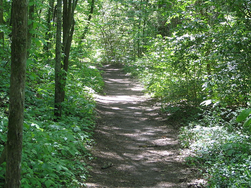
A few segments remain. The Natchez Trace was the method of travel for some, connecting Nashville, Tn to Natchez, MS. Officially established by Congress in the year 1800 as a national route, Andrew Jackson and many of his troops marched or rode (cavalry) through here and back during the Creek War and the War of 1812.
|
| Date | |
| Source | 19th Century Travel |
| Author | Brent Moore from Smyrna, TN |
Licensing
- You are free:
- to share – to copy, distribute and transmit the work
- to remix – to adapt the work
- Under the following conditions:
- attribution – You must give appropriate credit, provide a link to the license, and indicate if changes were made. You may do so in any reasonable manner, but not in any way that suggests the licensor endorses you or your use.
| This image, originally posted to Flickr, was reviewed on October 26, 2007 by the administrator or reviewer File Upload Bot (Magnus Manske), who confirmed that it was available on Flickr under the stated license on that date. |
File history
Click on a date/time to view the file as it appeared at that time.
| Date/Time | Thumbnail | Dimensions | User | Comment | |
|---|---|---|---|---|---|
| current | 05:16, 26 October 2007 |
| 2,048 × 1,536 (1.57 MB) | File Upload Bot (Magnus Manske) | {{Information |Description= A few segments remain. The Natchez Trace was the method of travel for some, connecting Nashville, Tn to Natchez, MS. Officially established by Congress in the year 1800 as a national route, Andrew Jackson and his troops marc |
File usage
Global file usage
The following other wikis use this file:
- Usage on cs.wikipedia.org
- Usage on fr.wikipedia.org
- Usage on pl.wiktionary.org
- Usage on www.wikidata.org
Metadata
Original file (2,048 × 1,536 pixels, file size: 1.57 MB, MIME type: image/jpeg)
| This is a file from the
Wikimedia Commons. Information from its
description page there is shown below. Commons is a freely licensed media file repository. You can help. |
Summary
| Description |
A few segments remain. The Natchez Trace was the method of travel for some, connecting Nashville, Tn to Natchez, MS. Officially established by Congress in the year 1800 as a national route, Andrew Jackson and many of his troops marched or rode (cavalry) through here and back during the Creek War and the War of 1812.
|
| Date | |
| Source | 19th Century Travel |
| Author | Brent Moore from Smyrna, TN |
Licensing
- You are free:
- to share – to copy, distribute and transmit the work
- to remix – to adapt the work
- Under the following conditions:
- attribution – You must give appropriate credit, provide a link to the license, and indicate if changes were made. You may do so in any reasonable manner, but not in any way that suggests the licensor endorses you or your use.
| This image, originally posted to Flickr, was reviewed on October 26, 2007 by the administrator or reviewer File Upload Bot (Magnus Manske), who confirmed that it was available on Flickr under the stated license on that date. |
File history
Click on a date/time to view the file as it appeared at that time.
| Date/Time | Thumbnail | Dimensions | User | Comment | |
|---|---|---|---|---|---|
| current | 05:16, 26 October 2007 |
| 2,048 × 1,536 (1.57 MB) | File Upload Bot (Magnus Manske) | {{Information |Description= A few segments remain. The Natchez Trace was the method of travel for some, connecting Nashville, Tn to Natchez, MS. Officially established by Congress in the year 1800 as a national route, Andrew Jackson and his troops marc |
File usage
Global file usage
The following other wikis use this file:
- Usage on cs.wikipedia.org
- Usage on fr.wikipedia.org
- Usage on pl.wiktionary.org
- Usage on www.wikidata.org