Original file (2,655 × 3,786 pixels, file size: 5.13 MB, MIME type: image/png)
| This is a file from the
Wikimedia Commons. Information from its
description page there is shown below. Commons is a freely licensed media file repository. You can help. |
Summary
| Description |
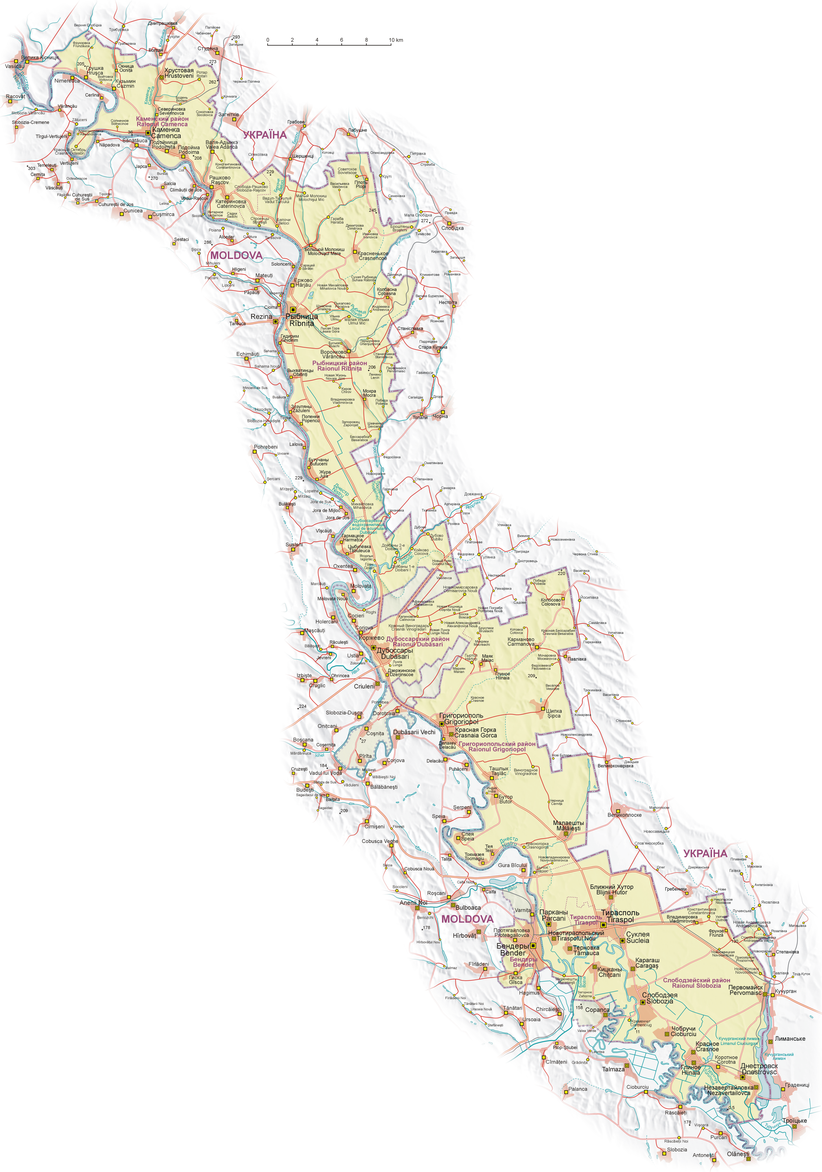
English: Map of Transnistria (with claimed area), based on Soviet and Ukrainian topographic map, and
Shuttle Radar Topography Mission (STRM).
Geographical names:
 Polski: Mapa
Naddniestrza (wraz z obszarem roszczeń). Mapa opracowana na podstawie radzieckich
map topograficznych w skali 1:100 000 z końca lat 80. oraz ukraińskich map topograficznych z lat 2002-2006, rzeźba terenu wygenerowana na podstawie danych
Shuttle Radar Topography Mission (STRM) udostępnionych przez
United States Geological Survey.
Nazewnictwo geograficzne:
 Español: Mapa de Transnistria, basado en mapas topográficos soviéticos y ucranianos, y en la
STRM. Nombres geográficos:
|
| Date | |
| Source | Own work |
| Author | Aotearoa |
| Other versions |
|


.png)


Licensing

|
Permission is granted to copy, distribute and/or modify this document under the terms of the GNU Free Documentation License, Version 1.2 or any later version published by the Free Software Foundation; with no Invariant Sections, no Front-Cover Texts, and no Back-Cover Texts. A copy of the license is included in the section entitled GNU Free Documentation License. |
| This file is licensed under the Creative Commons Attribution-Share Alike 3.0 Unported license. | ||
| ||
| This licensing tag was added to this file as part of the GFDL licensing update. |
|
This image has been assessed using the
Quality image guidelines and is considered a
Quality image.
|
File history
Click on a date/time to view the file as it appeared at that time.
| Date/Time | Thumbnail | Dimensions | User | Comment | |
|---|---|---|---|---|---|
| current | 05:08, 27 July 2011 |
| 2,655 × 3,786 (5.13 MB) | Nicolay Sidorov | + русское название села Коржево, исправил название села Zahorna - Загорное, а не "Захорна" |
| 10:18, 14 September 2008 |
 | 2,655 × 3,786 (5.21 MB) | Aotearoa | {{Information |Description= |Source= |Date= |Author= |Permission= |other_versions= }} | |
| 20:01, 25 August 2008 |
 | 2,655 × 3,790 (5.62 MB) | Aotearoa | {{Information |Description= |Source= |Date= |Author= |Permission= |other_versions= }} | |
| 19:39, 25 August 2008 |
 | 2,962 × 4,230 (6.21 MB) | Aotearoa | {{Information |Description= |Source= |Date= |Author= |Permission= |other_versions= }} | |
| 19:27, 25 August 2008 |
 | 3,054 × 4,271 (6.22 MB) | Aotearoa | {{Information |Description= |Source= |Date= |Author= |Permission= |other_versions= }} | |
| 18:51, 25 August 2008 |
 | 3,054 × 4,271 (6.22 MB) | Aotearoa | {{Information |Description={{en|1=Map of Transnistria, based on Soviet and Ucrainian topographic map, and Shuttle Radar Topography Mission (STRM). Names in Transnistria according Transnistrian government}} {{pl|1= |
File usage
Global file usage
The following other wikis use this file:
- Usage on ast.wikipedia.org
- Usage on ca.wikipedia.org
- Usage on cs.wikipedia.org
- Usage on de.wikipedia.org
- Usage on eo.wikipedia.org
- Usage on eu.wikipedia.org
- Usage on fr.wikipedia.org
- Usage on fr.wikinews.org
- Usage on gl.wikipedia.org
- Usage on he.wikipedia.org
- Usage on hu.wikipedia.org
- Usage on is.wikipedia.org
- Usage on ja.wikipedia.org
- Usage on li.wikipedia.org
- Usage on ml.wikipedia.org
- Usage on nl.wikipedia.org
- Usage on pa.wikipedia.org
- Usage on pl.wikipedia.org
- Wikipedysta:Aotearoa/brudnopis
- Wikipedia:Ilustracje na Medal/rysunki i animacje
- Wikipedia:Propozycje do Ilustracji na Medal/Naddniestrze.png
- Dyskusja pliku:Naddniestrze.png
- Wikipedysta:Aotearoa/mapy
- Szablon:Ilustracja na medal/2011-09-02
- Szablon:Ilustracja na medal/2012-02-14
- Szablon:Ilustracja na medal/2013-02-10
- Szablon:Ilustracja na medal/2014-08-16
- Wikipedysta:The Polish/Nieużywane szablony/Ilustracja na medal/1-500
- Wikipedysta:The Polish/Nieużywane szablony/Ilustracja na medal/501-1000
- Wikipedysta:The Polish/Nieużywane szablony/Ilustracja na medal/1001-1500
- Usage on pt.wikipedia.org
- Usage on ro.wikipedia.org
- Usage on ru.wikipedia.org
- Usage on sd.wikipedia.org
- Usage on sr.wikipedia.org
- Usage on su.wikipedia.org
View more global usage of this file.
Original file (2,655 × 3,786 pixels, file size: 5.13 MB, MIME type: image/png)
| This is a file from the
Wikimedia Commons. Information from its
description page there is shown below. Commons is a freely licensed media file repository. You can help. |
Summary
| Description |
English: Map of Transnistria (with claimed area), based on Soviet and Ukrainian topographic map, and
Shuttle Radar Topography Mission (STRM).
Geographical names:
Polski: Mapa
Naddniestrza (wraz z obszarem roszczeń). Mapa opracowana na podstawie radzieckich
map topograficznych w skali 1:100 000 z końca lat 80. oraz ukraińskich map topograficznych z lat 2002-2006, rzeźba terenu wygenerowana na podstawie danych
Shuttle Radar Topography Mission (STRM) udostępnionych przez
United States Geological Survey.
Nazewnictwo geograficzne:
Español: Mapa de Transnistria, basado en mapas topográficos soviéticos y ucranianos, y en la
STRM. Nombres geográficos:
|
| Date | |
| Source | Own work |
| Author | Aotearoa |
| Other versions |
|
Licensing
|
|
Permission is granted to copy, distribute and/or modify this document under the terms of the GNU Free Documentation License, Version 1.2 or any later version published by the Free Software Foundation; with no Invariant Sections, no Front-Cover Texts, and no Back-Cover Texts. A copy of the license is included in the section entitled GNU Free Documentation License. |
| This file is licensed under the Creative Commons Attribution-Share Alike 3.0 Unported license. | ||
| ||
| This licensing tag was added to this file as part of the GFDL licensing update. |
|
This image has been assessed using the
Quality image guidelines and is considered a
Quality image.
|
File history
Click on a date/time to view the file as it appeared at that time.
| Date/Time | Thumbnail | Dimensions | User | Comment | |
|---|---|---|---|---|---|
| current | 05:08, 27 July 2011 |
| 2,655 × 3,786 (5.13 MB) | Nicolay Sidorov | + русское название села Коржево, исправил название села Zahorna - Загорное, а не "Захорна" |
| 10:18, 14 September 2008 |
| 2,655 × 3,786 (5.21 MB) | Aotearoa | {{Information |Description= |Source= |Date= |Author= |Permission= |other_versions= }} | |
| 20:01, 25 August 2008 |
| 2,655 × 3,790 (5.62 MB) | Aotearoa | {{Information |Description= |Source= |Date= |Author= |Permission= |other_versions= }} | |
| 19:39, 25 August 2008 |
| 2,962 × 4,230 (6.21 MB) | Aotearoa | {{Information |Description= |Source= |Date= |Author= |Permission= |other_versions= }} | |
| 19:27, 25 August 2008 |
| 3,054 × 4,271 (6.22 MB) | Aotearoa | {{Information |Description= |Source= |Date= |Author= |Permission= |other_versions= }} | |
| 18:51, 25 August 2008 |
| 3,054 × 4,271 (6.22 MB) | Aotearoa | {{Information |Description={{en|1=Map of Transnistria, based on Soviet and Ucrainian topographic map, and Shuttle Radar Topography Mission (STRM). Names in Transnistria according Transnistrian government}} {{pl|1= |
File usage
Global file usage
The following other wikis use this file:
- Usage on ast.wikipedia.org
- Usage on ca.wikipedia.org
- Usage on cs.wikipedia.org
- Usage on de.wikipedia.org
- Usage on eo.wikipedia.org
- Usage on eu.wikipedia.org
- Usage on fr.wikipedia.org
- Usage on fr.wikinews.org
- Usage on gl.wikipedia.org
- Usage on he.wikipedia.org
- Usage on hu.wikipedia.org
- Usage on is.wikipedia.org
- Usage on ja.wikipedia.org
- Usage on li.wikipedia.org
- Usage on ml.wikipedia.org
- Usage on nl.wikipedia.org
- Usage on pa.wikipedia.org
- Usage on pl.wikipedia.org
- Wikipedysta:Aotearoa/brudnopis
- Wikipedia:Ilustracje na Medal/rysunki i animacje
- Wikipedia:Propozycje do Ilustracji na Medal/Naddniestrze.png
- Dyskusja pliku:Naddniestrze.png
- Wikipedysta:Aotearoa/mapy
- Szablon:Ilustracja na medal/2011-09-02
- Szablon:Ilustracja na medal/2012-02-14
- Szablon:Ilustracja na medal/2013-02-10
- Szablon:Ilustracja na medal/2014-08-16
- Wikipedysta:The Polish/Nieużywane szablony/Ilustracja na medal/1-500
- Wikipedysta:The Polish/Nieużywane szablony/Ilustracja na medal/501-1000
- Wikipedysta:The Polish/Nieużywane szablony/Ilustracja na medal/1001-1500
- Usage on pt.wikipedia.org
- Usage on ro.wikipedia.org
- Usage on ru.wikipedia.org
- Usage on sd.wikipedia.org
- Usage on sr.wikipedia.org
- Usage on su.wikipedia.org
View more global usage of this file.