Original file (1,024 × 500 pixels, file size: 37 KB, MIME type: image/png)
| This is a file from the
Wikimedia Commons. Information from its
description page there is shown below. Commons is a freely licensed media file repository. You can help. |
Summary

|
File:NUTS Map of Turkey.svg is a vector version of this file. It should be used in place of this PNG file when not inferior.
File:NUTS Map of Turkey.png →
File:NUTS Map of Turkey.svg
For more information, see
Help:SVG. |
 |
| Description |
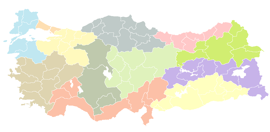
English: This map shows the first NUTS-level of the Turkish Republic
Türkçe: Bu harita Türkiye Cumhuriyeti'nin birinci İBBS-derecesini gösteriyor |
| Date | |
| Source | BlankMapTurkeyProvinces.png |
| Author | Fatih civelek |
| Permission ( Reusing this file) |
I grant permission for anyone to use this under the terms of GFDL license, see below |
| Other versions | Derivative works of this file: Secim2009Turkey.png |
Licensing
- You are free:
- to share – to copy, distribute and transmit the work
- to remix – to adapt the work
- Under the following conditions:
- attribution – You must give appropriate credit, provide a link to the license, and indicate if changes were made. You may do so in any reasonable manner, but not in any way that suggests the licensor endorses you or your use.
- share alike – If you remix, transform, or build upon the material, you must distribute your contributions under the same or compatible license as the original.

|
Permission is granted to copy, distribute and/or modify this document under the terms of the GNU Free Documentation License, Version 1.2 or any later version published by the Free Software Foundation; with no Invariant Sections, no Front-Cover Texts, and no Back-Cover Texts. A copy of the license is included in the section entitled GNU Free Documentation License. |
File history
Click on a date/time to view the file as it appeared at that time.
| Date/Time | Thumbnail | Dimensions | User | Comment | |
|---|---|---|---|---|---|
| current | 21:39, 18 March 2011 |
| 1,024 × 500 (37 KB) | Fatih civelek | {{Information |Description ={{en|1=This map shows the first NUTS-level of the Turkish Republic}} {{tr|1=Bu harita Türkiye Cumhuriyeti'nin birinci derece İBBS-derecesini gösteriyor}} |Source =BlankMapTurkeyProvinces.png |Author =[[Use |
File usage
More than 100 pages use this file. The following list shows the first 100 pages that use this file only. A full list is available.
- Adana
- Adana Province
- Adıyaman Province
- Afyonkarahisar Province
- Akhisar
- Aksaray Province
- Alanya
- Amasya Province
- Anamur
- Ankara
- Ankara Province
- Antakya
- Antalya Province
- Ardahan Province
- Artvin Province
- Aydın Province
- Ağrı Province
- Balıkesir Province
- Bartın Province
- Batman Province
- Bergama
- Beşiktaş
- Bilecik Province
- Bodrum
- Bolu Province
- Burdur Province
- Bursa
- Bursa Province
- Ceyhan
- Denizli
- Denizli Province
- Diyarbakır
- Diyarbakır Province
- Düzce Province
- Edirne Province
- Edremit, Balıkesir
- Elazığ Province
- Erzurum
- Erzurum Province
- Eskişehir Province
- Gaziantep
- Gaziantep Province
- Giresun Province
- Hakkâri Province
- Harran
- Hatay Province
- Haymana
- Imbros
- Isparta Province
- Iğdır Province
- Kahramanmaraş Province
- Karabük Province
- Karaman Province
- Karamürsel
- Kars Province
- Kartal
- Kastamonu Province
- Kayseri
- Kayseri Province
- Kocaeli Province
- Konya
- Konya Province
- Kozan, Adana
- Kuşadası
- Kırşehir Province
- Malatya
- Manisa Province
- Marmaris
- Mersin
- Muğla
- Muğla Province
- Muş Province
- Nevşehir Province
- Nusaybin
- Ordu Province
- Princes' Islands
- Rize Province
- Sakarya Province
- Samsun
- Samsun Province
- Seyhan
- Sivas Province
- Tarsus, Mersin
- Tekirdağ
- Tokat Province
- Trabzon
- Trabzon Province
- Urfa
- Uşak Province
- Van, Turkey
- Van Province
- Yalova Province
- Yozgat Province
- Zonguldak Province
- Çanakkale Province
- Çankırı Province
- Çorum Province
- Üsküdar
- İskenderun
- İzmir
View more links to this file.
Global file usage
The following other wikis use this file:
- Usage on ar.wikipedia.org
- أضنة (محافظة)
- بورصة (محافظة)
- محافظة أديامان
- أفيون قره حصار (محافظة)
- أغري (محافظة)
- أنقرة (محافظة)
- أنطاليا (محافظة)
- أرتوين (محافظة)
- أيدين (محافظة)
- بالق أسير (محافظة)
- عنتاب (محافظة)
- بيله جك (محافظة)
- بينكل (محافظة)
- بدليس (محافظة)
- بولو (محافظة)
- بوردور (محافظة)
- جنق قلعة (محافظة)
- جانقري (محافظة)
- جوروم (محافظة)
- دنيزلي (محافظة)
- ديار بكر (محافظة)
- محافظة أدرنة
- معمورة العزيز (محافظة)
- أرزنجان (محافظة)
- أرضروم (محافظة)
- إسكي شهر (محافظة)
- حكاري (ولاية)
- حطاي (محافظة)
- إسبرطة (محافظة)
- إزمير (محافظة)
- قارص (محافظة)
- قرشهر (محافظة)
- كوتاهية (محافظة)
- ملطية (محافظة)
- محافظة مانيسا
- محافظة مرعش
- ماردين (ولاية)
- مغلة (ولاية)
- محافظة نوشهر
- نيدا (محافظة)
- أردو (محافظة)
- ريزا (محافظة)
- تكيرداغ (محافظة)
- توقاد (محافظة)
- طرابزون (محافظة)
- عشاق (محافظة)
- وان (محافظة)
- يوزغات (محافظة)
- زونغولداق (محافظة)
- آق سراي (محافظة)
View more global usage of this file.
Original file (1,024 × 500 pixels, file size: 37 KB, MIME type: image/png)
| This is a file from the
Wikimedia Commons. Information from its
description page there is shown below. Commons is a freely licensed media file repository. You can help. |
Summary
|
|
File:NUTS Map of Turkey.svg is a vector version of this file. It should be used in place of this PNG file when not inferior.
File:NUTS Map of Turkey.png →
File:NUTS Map of Turkey.svg
For more information, see
Help:SVG. |
|
| Description |
English: This map shows the first NUTS-level of the Turkish Republic
Türkçe: Bu harita Türkiye Cumhuriyeti'nin birinci İBBS-derecesini gösteriyor |
| Date | |
| Source | BlankMapTurkeyProvinces.png |
| Author | Fatih civelek |
| Permission ( Reusing this file) |
I grant permission for anyone to use this under the terms of GFDL license, see below |
| Other versions | Derivative works of this file: Secim2009Turkey.png |
Licensing
- You are free:
- to share – to copy, distribute and transmit the work
- to remix – to adapt the work
- Under the following conditions:
- attribution – You must give appropriate credit, provide a link to the license, and indicate if changes were made. You may do so in any reasonable manner, but not in any way that suggests the licensor endorses you or your use.
- share alike – If you remix, transform, or build upon the material, you must distribute your contributions under the same or compatible license as the original.
|
|
Permission is granted to copy, distribute and/or modify this document under the terms of the GNU Free Documentation License, Version 1.2 or any later version published by the Free Software Foundation; with no Invariant Sections, no Front-Cover Texts, and no Back-Cover Texts. A copy of the license is included in the section entitled GNU Free Documentation License. |
File history
Click on a date/time to view the file as it appeared at that time.
| Date/Time | Thumbnail | Dimensions | User | Comment | |
|---|---|---|---|---|---|
| current | 21:39, 18 March 2011 |
| 1,024 × 500 (37 KB) | Fatih civelek | {{Information |Description ={{en|1=This map shows the first NUTS-level of the Turkish Republic}} {{tr|1=Bu harita Türkiye Cumhuriyeti'nin birinci derece İBBS-derecesini gösteriyor}} |Source =BlankMapTurkeyProvinces.png |Author =[[Use |
File usage
More than 100 pages use this file. The following list shows the first 100 pages that use this file only. A full list is available.
- Adana
- Adana Province
- Adıyaman Province
- Afyonkarahisar Province
- Akhisar
- Aksaray Province
- Alanya
- Amasya Province
- Anamur
- Ankara
- Ankara Province
- Antakya
- Antalya Province
- Ardahan Province
- Artvin Province
- Aydın Province
- Ağrı Province
- Balıkesir Province
- Bartın Province
- Batman Province
- Bergama
- Beşiktaş
- Bilecik Province
- Bodrum
- Bolu Province
- Burdur Province
- Bursa
- Bursa Province
- Ceyhan
- Denizli
- Denizli Province
- Diyarbakır
- Diyarbakır Province
- Düzce Province
- Edirne Province
- Edremit, Balıkesir
- Elazığ Province
- Erzurum
- Erzurum Province
- Eskişehir Province
- Gaziantep
- Gaziantep Province
- Giresun Province
- Hakkâri Province
- Harran
- Hatay Province
- Haymana
- Imbros
- Isparta Province
- Iğdır Province
- Kahramanmaraş Province
- Karabük Province
- Karaman Province
- Karamürsel
- Kars Province
- Kartal
- Kastamonu Province
- Kayseri
- Kayseri Province
- Kocaeli Province
- Konya
- Konya Province
- Kozan, Adana
- Kuşadası
- Kırşehir Province
- Malatya
- Manisa Province
- Marmaris
- Mersin
- Muğla
- Muğla Province
- Muş Province
- Nevşehir Province
- Nusaybin
- Ordu Province
- Princes' Islands
- Rize Province
- Sakarya Province
- Samsun
- Samsun Province
- Seyhan
- Sivas Province
- Tarsus, Mersin
- Tekirdağ
- Tokat Province
- Trabzon
- Trabzon Province
- Urfa
- Uşak Province
- Van, Turkey
- Van Province
- Yalova Province
- Yozgat Province
- Zonguldak Province
- Çanakkale Province
- Çankırı Province
- Çorum Province
- Üsküdar
- İskenderun
- İzmir
View more links to this file.
Global file usage
The following other wikis use this file:
- Usage on ar.wikipedia.org
- أضنة (محافظة)
- بورصة (محافظة)
- محافظة أديامان
- أفيون قره حصار (محافظة)
- أغري (محافظة)
- أنقرة (محافظة)
- أنطاليا (محافظة)
- أرتوين (محافظة)
- أيدين (محافظة)
- بالق أسير (محافظة)
- عنتاب (محافظة)
- بيله جك (محافظة)
- بينكل (محافظة)
- بدليس (محافظة)
- بولو (محافظة)
- بوردور (محافظة)
- جنق قلعة (محافظة)
- جانقري (محافظة)
- جوروم (محافظة)
- دنيزلي (محافظة)
- ديار بكر (محافظة)
- محافظة أدرنة
- معمورة العزيز (محافظة)
- أرزنجان (محافظة)
- أرضروم (محافظة)
- إسكي شهر (محافظة)
- حكاري (ولاية)
- حطاي (محافظة)
- إسبرطة (محافظة)
- إزمير (محافظة)
- قارص (محافظة)
- قرشهر (محافظة)
- كوتاهية (محافظة)
- ملطية (محافظة)
- محافظة مانيسا
- محافظة مرعش
- ماردين (ولاية)
- مغلة (ولاية)
- محافظة نوشهر
- نيدا (محافظة)
- أردو (محافظة)
- ريزا (محافظة)
- تكيرداغ (محافظة)
- توقاد (محافظة)
- طرابزون (محافظة)
- عشاق (محافظة)
- وان (محافظة)
- يوزغات (محافظة)
- زونغولداق (محافظة)
- آق سراي (محافظة)
View more global usage of this file.