
Size of this preview:
800 × 550 pixels. Other resolutions:
320 × 220 pixels |
640 × 440 pixels |
1,024 × 704 pixels |
1,280 × 880 pixels |
1,493 × 1,027 pixels.
Original file (1,493 × 1,027 pixels, file size: 106 KB, MIME type: image/jpeg)
| This is a file from the
Wikimedia Commons. Information from its
description page there is shown below. Commons is a freely licensed media file repository. You can help. |
Summary
| Description |
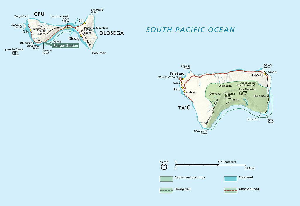
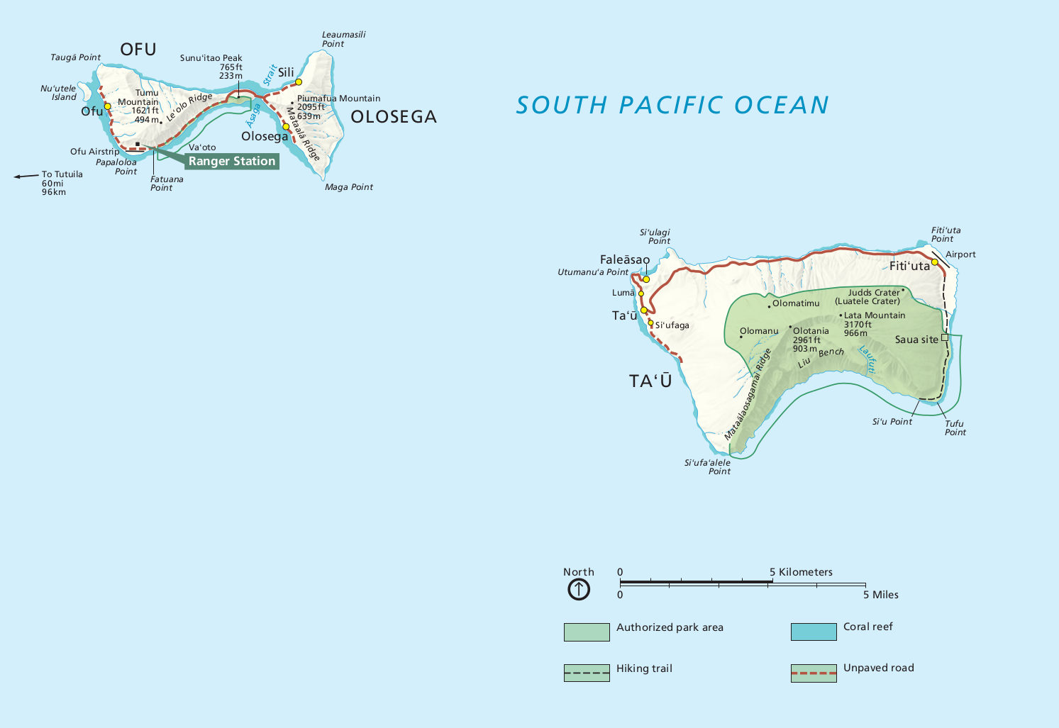
English: Map of American Samoa lands on Manu’a Islands, including both Ofu and Ta’u. |
| Date | |
| Source | U.S. National Park Service ( http://npmaps.com/wp-content/uploads/american-samoa-manua-islands-map.jpg) |
| Author | U.S. National Park Service, restoration/cleanup by Matt Holly |
| Other versions |
 |
Licensing
| This image or media file contains material based on a work of a National Park Service employee, created as part of that person's official duties. As a work of the U.S. federal government, such work is in the public domain in the United States. See the NPS website and NPS copyright policy for more information. |
File history
Click on a date/time to view the file as it appeared at that time.
| Date/Time | Thumbnail | Dimensions | User | Comment | |
|---|---|---|---|---|---|
| current | 06:33, 12 May 2017 |
| 1,493 × 1,027 (106 KB) | RKBot | =={{int:filedesc}}== {{Information |description= {{en|1=Map of American Samoa lands on Manu’a Islands, including both Ofu and Ta’u.}} |date= 2016-02-22 |source= U.S. National Park Service (http://npmaps.com/wp-content/uploads/american-samoa-manua-i... |
File usage
The following pages on the English Wikipedia use this file (pages on other projects are not listed):
Global file usage
The following other wikis use this file:
- Usage on ban.wikipedia.org
- Usage on fr.wikipedia.org
- Usage on ur.wikipedia.org
Size of this preview:
800 × 550 pixels. Other resolutions:
320 × 220 pixels |
640 × 440 pixels |
1,024 × 704 pixels |
1,280 × 880 pixels |
1,493 × 1,027 pixels.
Original file (1,493 × 1,027 pixels, file size: 106 KB, MIME type: image/jpeg)
| This is a file from the
Wikimedia Commons. Information from its
description page there is shown below. Commons is a freely licensed media file repository. You can help. |
Summary
| Description |
English: Map of American Samoa lands on Manu’a Islands, including both Ofu and Ta’u. |
| Date | |
| Source | U.S. National Park Service ( http://npmaps.com/wp-content/uploads/american-samoa-manua-islands-map.jpg) |
| Author | U.S. National Park Service, restoration/cleanup by Matt Holly |
| Other versions |
|
Licensing
| This image or media file contains material based on a work of a National Park Service employee, created as part of that person's official duties. As a work of the U.S. federal government, such work is in the public domain in the United States. See the NPS website and NPS copyright policy for more information. |
File history
Click on a date/time to view the file as it appeared at that time.
| Date/Time | Thumbnail | Dimensions | User | Comment | |
|---|---|---|---|---|---|
| current | 06:33, 12 May 2017 |
| 1,493 × 1,027 (106 KB) | RKBot | =={{int:filedesc}}== {{Information |description= {{en|1=Map of American Samoa lands on Manu’a Islands, including both Ofu and Ta’u.}} |date= 2016-02-22 |source= U.S. National Park Service (http://npmaps.com/wp-content/uploads/american-samoa-manua-i... |
File usage
The following pages on the English Wikipedia use this file (pages on other projects are not listed):
Global file usage
The following other wikis use this file:
- Usage on ban.wikipedia.org
- Usage on fr.wikipedia.org
- Usage on ur.wikipedia.org