
Size of this PNG preview of this SVG file:
648 × 600 pixels. Other resolutions:
259 × 240 pixels |
518 × 480 pixels |
830 × 768 pixels |
1,106 × 1,024 pixels |
2,212 × 2,048 pixels |
971 × 899 pixels.
Original file (SVG file, nominally 971 × 899 pixels, file size: 1.88 MB)
| This is a file from the
Wikimedia Commons. Information from its
description page there is shown below. Commons is a freely licensed media file repository. You can help. |
Summary
| Description |
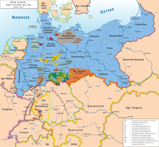
English: Map of North German Confederation 1866–1871
Deutsch: Karte des Norddeutschen Bundes 1866–1871 |
||||||||
| Date | |||||||||
| Source | own drawing/Source of Information: Putzger – Historischer Weltatlas, 89. Auflage, 1965; Westermanns Großer Atlas zur Weltgeschichte, 1969; Haacks geographischer Atlas. VEB Hermann Haack Geographisch-Kartographische Anstalt, Gotha/Leipzig, 1. Auflage, 1979; dtv-Atlas zur Weltgeschichte Band 1: Von den Anfängen bis zur Französischen Revolution; 23. Aufl. 1989, ISBN 3-423-03002-X | ||||||||
| Author | Ziegelbrenner | ||||||||
| Permission ( Reusing this file) |
I, the copyright holder of this work, hereby publish it under the following licenses:
This file is licensed under the
Creative Commons
Attribution 2.5 Generic license.
You may select the license of your choice. |
||||||||
| Other versions | File:Norddeutscher Bund.png |

File history
Click on a date/time to view the file as it appeared at that time.
| Date/Time | Thumbnail | Dimensions | User | Comment | |
|---|---|---|---|---|---|
| current | 21:06, 6 June 2014 |
| 971 × 899 (1.88 MB) | Aeroid | Amt Ritzebüttel (zu Hamburg) war hinter anderen Layern versteckt |
| 12:17, 2 June 2014 |
 | 971 × 899 (2 MB) | Ziegelbrenner | Typo | |
| 10:48, 2 June 2014 |
 | 971 × 899 (2 MB) | Ziegelbrenner | {{Information |Description ={{en|1=Map of North German Confederation 1866–1871}} {{de|1=Karte des Norddeutschen Bundes 1866–1871}} |Source =|Source={{own}}/Source of Information: Putzger – Historischer Weltatlas, 89. Auflage, 1965... |
File usage
The following pages on the English Wikipedia use this file (pages on other projects are not listed):
- Bremen (state)
- Duchy of Anhalt
- Duchy of Brunswick
- Free City of Lübeck
- Grand Duchy of Hesse
- Grand Duchy of Mecklenburg-Schwerin
- Grand Duchy of Mecklenburg-Strelitz
- Grand Duchy of Oldenburg
- Hamburg
- History of Germany
- History of Hamburg
- Kingdom of Prussia
- Kingdom of Saxony
- List of historic states of Germany
- Mainlinie
- North German Confederation
- November Treaties
- Oldenburg (state)
- Principality of Lippe
- Principality of Reuss-Gera
- Principality of Reuss-Greiz
- Principality of Schaumburg-Lippe
- Principality of Waldeck and Pyrmont
- Prussia
- Saxe-Altenburg
- Saxe-Coburg and Gotha
- Saxe-Lauenburg
- Saxe-Meiningen
- Saxe-Weimar-Eisenach
- Schwarzburg-Rudolstadt
- Schwarzburg-Sondershausen
- South German Confederation
- User:Falcaorib
- User:Stephen2nd/Prussian Empire
- Template:States of the North German Confederation
- Category:North German Confederation
Global file usage
The following other wikis use this file:
- Usage on als.wikipedia.org
- Usage on ar.wikipedia.org
- Usage on ast.wikipedia.org
- Usage on azb.wikipedia.org
- Usage on da.wikipedia.org
- Usage on de.wikipedia.org
- 12. Februar
- 1866
- Norddeutschland
- Deutsch-Französischer Krieg
- Diskussion:Deutsch-Französischer Krieg
- Prager Frieden (1866)
- Schutz- und Trutzbündnisse 1866
- Amt Ritzebüttel
- Residenzstadt
- Novemberverträge
- Deutschland
- Augustverträge
- Süddeutscher Bund
- Herzogtum Limburg (1839–1866)
- Wahlrecht im Norddeutschen Bund und im Deutschen Kaiserreich
- Benutzer:Ziegelbrenner/Meine Bilder auf Commons
- Frankfurter Reichswahlgesetz
- Diplomatie des Norddeutschen Bundes
- Seekrieg im Deutsch-Französischen Krieg
- Auflösung des Deutschen Bundes
- Interpellation Lasker
- Diskussion:Weißwurstäquator/Archiv/1
- Surveillante (Schiff, 1867)
- Seegefecht vor Hiddensee
- Jeanne d’Arc (Schiff, 1868)
- Usage on de.wikisource.org
- Usage on el.wikipedia.org
- Usage on et.wikipedia.org
- Usage on fi.wikipedia.org
- Usage on frr.wikipedia.org
- Usage on fr.wikipedia.org
- Usage on fr.wiktionary.org
- Usage on fy.wikipedia.org
- Usage on gl.wikipedia.org
- Usage on he.wikipedia.org
- Usage on hu.wikipedia.org
- Usage on it.wikipedia.org
- Usage on ja.wikipedia.org
- Usage on lv.wikipedia.org
View more global usage of this file.
Metadata
Size of this PNG preview of this SVG file:
648 × 600 pixels. Other resolutions:
259 × 240 pixels |
518 × 480 pixels |
830 × 768 pixels |
1,106 × 1,024 pixels |
2,212 × 2,048 pixels |
971 × 899 pixels.
Original file (SVG file, nominally 971 × 899 pixels, file size: 1.88 MB)
| This is a file from the
Wikimedia Commons. Information from its
description page there is shown below. Commons is a freely licensed media file repository. You can help. |
Summary
| Description |
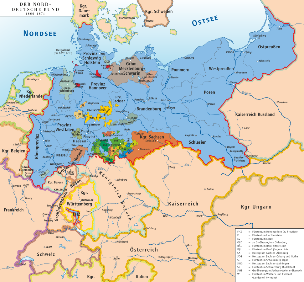
English: Map of North German Confederation 1866–1871
Deutsch: Karte des Norddeutschen Bundes 1866–1871 |
||||||||
| Date | |||||||||
| Source | own drawing/Source of Information: Putzger – Historischer Weltatlas, 89. Auflage, 1965; Westermanns Großer Atlas zur Weltgeschichte, 1969; Haacks geographischer Atlas. VEB Hermann Haack Geographisch-Kartographische Anstalt, Gotha/Leipzig, 1. Auflage, 1979; dtv-Atlas zur Weltgeschichte Band 1: Von den Anfängen bis zur Französischen Revolution; 23. Aufl. 1989, ISBN 3-423-03002-X | ||||||||
| Author | Ziegelbrenner | ||||||||
| Permission ( Reusing this file) |
I, the copyright holder of this work, hereby publish it under the following licenses:
This file is licensed under the
Creative Commons
Attribution 2.5 Generic license.
You may select the license of your choice. |
||||||||
| Other versions | File:Norddeutscher Bund.png |
File history
Click on a date/time to view the file as it appeared at that time.
| Date/Time | Thumbnail | Dimensions | User | Comment | |
|---|---|---|---|---|---|
| current | 21:06, 6 June 2014 |
| 971 × 899 (1.88 MB) | Aeroid | Amt Ritzebüttel (zu Hamburg) war hinter anderen Layern versteckt |
| 12:17, 2 June 2014 |
| 971 × 899 (2 MB) | Ziegelbrenner | Typo | |
| 10:48, 2 June 2014 |
| 971 × 899 (2 MB) | Ziegelbrenner | {{Information |Description ={{en|1=Map of North German Confederation 1866–1871}} {{de|1=Karte des Norddeutschen Bundes 1866–1871}} |Source =|Source={{own}}/Source of Information: Putzger – Historischer Weltatlas, 89. Auflage, 1965... |
File usage
The following pages on the English Wikipedia use this file (pages on other projects are not listed):
- Bremen (state)
- Duchy of Anhalt
- Duchy of Brunswick
- Free City of Lübeck
- Grand Duchy of Hesse
- Grand Duchy of Mecklenburg-Schwerin
- Grand Duchy of Mecklenburg-Strelitz
- Grand Duchy of Oldenburg
- Hamburg
- History of Germany
- History of Hamburg
- Kingdom of Prussia
- Kingdom of Saxony
- List of historic states of Germany
- Mainlinie
- North German Confederation
- November Treaties
- Oldenburg (state)
- Principality of Lippe
- Principality of Reuss-Gera
- Principality of Reuss-Greiz
- Principality of Schaumburg-Lippe
- Principality of Waldeck and Pyrmont
- Prussia
- Saxe-Altenburg
- Saxe-Coburg and Gotha
- Saxe-Lauenburg
- Saxe-Meiningen
- Saxe-Weimar-Eisenach
- Schwarzburg-Rudolstadt
- Schwarzburg-Sondershausen
- South German Confederation
- User:Falcaorib
- User:Stephen2nd/Prussian Empire
- Template:States of the North German Confederation
- Category:North German Confederation
Global file usage
The following other wikis use this file:
- Usage on als.wikipedia.org
- Usage on ar.wikipedia.org
- Usage on ast.wikipedia.org
- Usage on azb.wikipedia.org
- Usage on da.wikipedia.org
- Usage on de.wikipedia.org
- 12. Februar
- 1866
- Norddeutschland
- Deutsch-Französischer Krieg
- Diskussion:Deutsch-Französischer Krieg
- Prager Frieden (1866)
- Schutz- und Trutzbündnisse 1866
- Amt Ritzebüttel
- Residenzstadt
- Novemberverträge
- Deutschland
- Augustverträge
- Süddeutscher Bund
- Herzogtum Limburg (1839–1866)
- Wahlrecht im Norddeutschen Bund und im Deutschen Kaiserreich
- Benutzer:Ziegelbrenner/Meine Bilder auf Commons
- Frankfurter Reichswahlgesetz
- Diplomatie des Norddeutschen Bundes
- Seekrieg im Deutsch-Französischen Krieg
- Auflösung des Deutschen Bundes
- Interpellation Lasker
- Diskussion:Weißwurstäquator/Archiv/1
- Surveillante (Schiff, 1867)
- Seegefecht vor Hiddensee
- Jeanne d’Arc (Schiff, 1868)
- Usage on de.wikisource.org
- Usage on el.wikipedia.org
- Usage on et.wikipedia.org
- Usage on fi.wikipedia.org
- Usage on frr.wikipedia.org
- Usage on fr.wikipedia.org
- Usage on fr.wiktionary.org
- Usage on fy.wikipedia.org
- Usage on gl.wikipedia.org
- Usage on he.wikipedia.org
- Usage on hu.wikipedia.org
- Usage on it.wikipedia.org
- Usage on ja.wikipedia.org
- Usage on lv.wikipedia.org
View more global usage of this file.