Photos • Location


Size of this preview:
456 × 599 pixels. Other resolutions:
183 × 240 pixels |
365 × 480 pixels |
584 × 768 pixels |
779 × 1,024 pixels |
1,490 × 1,958 pixels.
Original file (1,490 × 1,958 pixels, file size: 1.18 MB, MIME type: image/jpeg)
| This is a file from the
Wikimedia Commons. Information from its
description page there is shown below. Commons is a freely licensed media file repository. You can help. |
.jpg)
Summary
| Description |
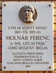
English: Plaque commemorative to Mr. Ferenc Molnár (1878-1952) Hungarian writer and journalist, the author of the novel "The Paul Street Boys". It is affixed on the wall of the primary school where the novelist was a student from 1887 to 1895. The plate with the bronze relief by the artist Johanna Götz was unveiled on September 30, 2014. (Budapest, District IX, Lónyay Street Nr 4)
Français : Plaque commémorative à M. Ferenc Molnár (1878–1952) écrivain et journaliste hongrois, l'auteur du roman « Les Garçons de la rue Paul ». Elle est apposée sur le mur de l'école primaire où le romancier était élève de 1887 à 1895. La plaque avec le relief en bronze réalisé par l'artiste Johanna Götz a été dévoilé le 30 septembre 2014. (4, rue Lónyay, Budapest 9e arr.)
Magyar: Molnár Ferenc (1878–1952) magyar író, újságíró, a Pál utcai fiúk szerzőjének emléktáblája annak az általános iskolának a falán, ahol 1887 és 1895 között tanult. A bronz dombormű Götz Johanna szobrász alkotása. Felavatva 2014. szeptember 30-én. (Budapest IX. ker., Lónyay utca 4.) |
| Date | Taken on 19 December 2017, 11:38:07 |
| Source | Own work |
| Author | Fekist |
| Camera location |
| View this and other nearby images on: OpenStreetMap |
|
|---|
.jpg¶ms=047.487408_N_0019.061306_E_globe:Earth_type:camera__&language=en)
Licensing
I, the copyright holder of this work, hereby publish it under the following license:
This file is licensed under the
Creative Commons
Attribution-Share Alike 4.0 International license.
- You are free:
- to share – to copy, distribute and transmit the work
- to remix – to adapt the work
- Under the following conditions:
- attribution – You must give appropriate credit, provide a link to the license, and indicate if changes were made. You may do so in any reasonable manner, but not in any way that suggests the licensor endorses you or your use.
- share alike – If you remix, transform, or build upon the material, you must distribute your contributions under the same or compatible license as the original.
File history
Click on a date/time to view the file as it appeared at that time.
| Date/Time | Thumbnail | Dimensions | User | Comment | |
|---|---|---|---|---|---|
| current | 13:10, 3 January 2018 |
| 1,490 × 1,958 (1.18 MB) | Fekist | User created page with UploadWizard |
File usage
The following pages on the English Wikipedia use this file (pages on other projects are not listed):
Global file usage
The following other wikis use this file:
- Usage on bs.wikipedia.org
- Usage on hu.wikipedia.org
Metadata
.jpg)
Size of this preview:
456 × 599 pixels. Other resolutions:
183 × 240 pixels |
365 × 480 pixels |
584 × 768 pixels |
779 × 1,024 pixels |
1,490 × 1,958 pixels.
Original file (1,490 × 1,958 pixels, file size: 1.18 MB, MIME type: image/jpeg)
| This is a file from the
Wikimedia Commons. Information from its
description page there is shown below. Commons is a freely licensed media file repository. You can help. |
Summary
| Description |
English: Plaque commemorative to Mr. Ferenc Molnár (1878-1952) Hungarian writer and journalist, the author of the novel "The Paul Street Boys". It is affixed on the wall of the primary school where the novelist was a student from 1887 to 1895. The plate with the bronze relief by the artist Johanna Götz was unveiled on September 30, 2014. (Budapest, District IX, Lónyay Street Nr 4)
Français : Plaque commémorative à M. Ferenc Molnár (1878–1952) écrivain et journaliste hongrois, l'auteur du roman « Les Garçons de la rue Paul ». Elle est apposée sur le mur de l'école primaire où le romancier était élève de 1887 à 1895. La plaque avec le relief en bronze réalisé par l'artiste Johanna Götz a été dévoilé le 30 septembre 2014. (4, rue Lónyay, Budapest 9e arr.)
Magyar: Molnár Ferenc (1878–1952) magyar író, újságíró, a Pál utcai fiúk szerzőjének emléktáblája annak az általános iskolának a falán, ahol 1887 és 1895 között tanult. A bronz dombormű Götz Johanna szobrász alkotása. Felavatva 2014. szeptember 30-én. (Budapest IX. ker., Lónyay utca 4.) |
| Date | Taken on 19 December 2017, 11:38:07 |
| Source | Own work |
| Author | Fekist |
| Camera location |
| View this and other nearby images on: OpenStreetMap |
|
|---|
Licensing
I, the copyright holder of this work, hereby publish it under the following license:
This file is licensed under the
Creative Commons
Attribution-Share Alike 4.0 International license.
- You are free:
- to share – to copy, distribute and transmit the work
- to remix – to adapt the work
- Under the following conditions:
- attribution – You must give appropriate credit, provide a link to the license, and indicate if changes were made. You may do so in any reasonable manner, but not in any way that suggests the licensor endorses you or your use.
- share alike – If you remix, transform, or build upon the material, you must distribute your contributions under the same or compatible license as the original.
File history
Click on a date/time to view the file as it appeared at that time.
| Date/Time | Thumbnail | Dimensions | User | Comment | |
|---|---|---|---|---|---|
| current | 13:10, 3 January 2018 |
| 1,490 × 1,958 (1.18 MB) | Fekist | User created page with UploadWizard |
File usage
The following pages on the English Wikipedia use this file (pages on other projects are not listed):
Global file usage
The following other wikis use this file:
- Usage on bs.wikipedia.org
- Usage on hu.wikipedia.org