Size of this preview:
356 × 599 pixels. Other resolutions:
142 × 240 pixels |
592 × 996 pixels.
Original file (592 × 996 pixels, file size: 612 KB, MIME type: image/jpeg)
| This is a file from the
Wikimedia Commons. Information from its
description page there is shown below. Commons is a freely licensed media file repository. You can help. |
Summary
| Description |
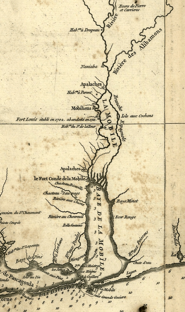
English: A detail of Anville's 1732 map of Louisiana showing Mobile Bay, the Mobile colony, and surrounding Native American settlements and villages. Français : Carte de la Louisiane par le Sr. d'Anville. Dressée en mai 1732. [Gravée par] Guille. de la Haye. |
||||||||||||||||||||
| Date | created 1732, published in Paris in 1752. | ||||||||||||||||||||
| Source |
|
||||||||||||||||||||
| Author |
|
||||||||||||||||||||
| Permission ( Reusing this file) |
|
||||||||||||||||||||
| Other versions | http://hdl.loc.gov/loc.gmd/g3860.ct000695 | ||||||||||||||||||||


File history
Click on a date/time to view the file as it appeared at that time.
| Date/Time | Thumbnail | Dimensions | User | Comment | |
|---|---|---|---|---|---|
| current | 19:09, 6 February 2008 |
| 592 × 996 (612 KB) | Altairisfar | == Summary == {{Information |Description={{en|A detail of Anville's 1732 map of Louisiana showing Mobile Bay, the Mobile colony, and surrounding Native American settlements and villages.}}{{fr|Carte de la Louisiane par le Sr. d'Anville. Dressée en mai 17 |
File usage
The following pages on the English Wikipedia use this file (pages on other projects are not listed):
Metadata
Size of this preview:
356 × 599 pixels. Other resolutions:
142 × 240 pixels |
592 × 996 pixels.
Original file (592 × 996 pixels, file size: 612 KB, MIME type: image/jpeg)
| This is a file from the
Wikimedia Commons. Information from its
description page there is shown below. Commons is a freely licensed media file repository. You can help. |
Summary
| Description |
English: A detail of Anville's 1732 map of Louisiana showing Mobile Bay, the Mobile colony, and surrounding Native American settlements and villages. Français : Carte de la Louisiane par le Sr. d'Anville. Dressée en mai 1732. [Gravée par] Guille. de la Haye. |
||||||||||||||||||||
| Date | created 1732, published in Paris in 1752. | ||||||||||||||||||||
| Source |
|
||||||||||||||||||||
| Author |
|
||||||||||||||||||||
| Permission ( Reusing this file) |
|
||||||||||||||||||||
| Other versions | http://hdl.loc.gov/loc.gmd/g3860.ct000695 | ||||||||||||||||||||
File history
Click on a date/time to view the file as it appeared at that time.
| Date/Time | Thumbnail | Dimensions | User | Comment | |
|---|---|---|---|---|---|
| current | 19:09, 6 February 2008 |
| 592 × 996 (612 KB) | Altairisfar | == Summary == {{Information |Description={{en|A detail of Anville's 1732 map of Louisiana showing Mobile Bay, the Mobile colony, and surrounding Native American settlements and villages.}}{{fr|Carte de la Louisiane par le Sr. d'Anville. Dressée en mai 17 |
File usage
The following pages on the English Wikipedia use this file (pages on other projects are not listed):