
Size of this preview:
800 × 430 pixels. Other resolutions:
320 × 172 pixels |
640 × 344 pixels |
1,024 × 551 pixels |
1,280 × 688 pixels |
2,560 × 1,377 pixels |
4,932 × 2,652 pixels.
Original file (4,932 × 2,652 pixels, file size: 8.3 MB, MIME type: image/jpeg)
| This is a file from the
Wikimedia Commons. Information from its
description page there is shown below. Commons is a freely licensed media file repository. You can help. |
Summary
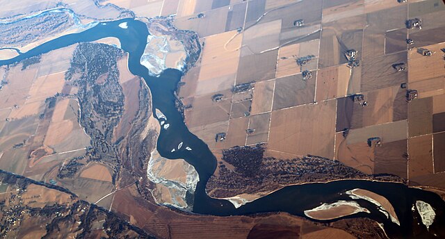
| Description | The Missouri River in winter downstream from Yankton, South Dakota, with Nebraska below and South Dakota above. Bottom left is bluff Quaternary loess (soil deposited by wind) and other buried soil over over Cretaceous Niobrara Formation chalk and Carlile shale. All of this was under the far edge of the Wisconsin Ice Sheet, which departed around 50,000 years ago. |
| Date | |
| Source | 2016_12_29_ewr-lax_096 |
| Author | Doc Searls from Santa Barbara, USA |
Licensing
This file is licensed under the
Creative Commons
Attribution 2.0 Generic license.
- You are free:
- to share – to copy, distribute and transmit the work
- to remix – to adapt the work
- Under the following conditions:
- attribution – You must give appropriate credit, provide a link to the license, and indicate if changes were made. You may do so in any reasonable manner, but not in any way that suggests the licensor endorses you or your use.
| This image was originally posted to Flickr by dsearls at https://flickr.com/photos/52614599@N00/34870792576. It was reviewed on 10 August 2017 by FlickreviewR and was confirmed to be licensed under the terms of the cc-by-2.0. |
File history
Click on a date/time to view the file as it appeared at that time.
| Date/Time | Thumbnail | Dimensions | User | Comment | |
|---|---|---|---|---|---|
| current | 18:36, 10 August 2017 |
| 4,932 × 2,652 (8.3 MB) | Tillman | Transferred from Flickr via Flickr2Commons |
File usage
The following pages on the English Wikipedia use this file (pages on other projects are not listed):
Metadata
Size of this preview:
800 × 430 pixels. Other resolutions:
320 × 172 pixels |
640 × 344 pixels |
1,024 × 551 pixels |
1,280 × 688 pixels |
2,560 × 1,377 pixels |
4,932 × 2,652 pixels.
Original file (4,932 × 2,652 pixels, file size: 8.3 MB, MIME type: image/jpeg)
| This is a file from the
Wikimedia Commons. Information from its
description page there is shown below. Commons is a freely licensed media file repository. You can help. |
Summary
| Description | The Missouri River in winter downstream from Yankton, South Dakota, with Nebraska below and South Dakota above. Bottom left is bluff Quaternary loess (soil deposited by wind) and other buried soil over over Cretaceous Niobrara Formation chalk and Carlile shale. All of this was under the far edge of the Wisconsin Ice Sheet, which departed around 50,000 years ago. |
| Date | |
| Source | 2016_12_29_ewr-lax_096 |
| Author | Doc Searls from Santa Barbara, USA |
Licensing
This file is licensed under the
Creative Commons
Attribution 2.0 Generic license.
- You are free:
- to share – to copy, distribute and transmit the work
- to remix – to adapt the work
- Under the following conditions:
- attribution – You must give appropriate credit, provide a link to the license, and indicate if changes were made. You may do so in any reasonable manner, but not in any way that suggests the licensor endorses you or your use.
| This image was originally posted to Flickr by dsearls at https://flickr.com/photos/52614599@N00/34870792576. It was reviewed on 10 August 2017 by FlickreviewR and was confirmed to be licensed under the terms of the cc-by-2.0. |
File history
Click on a date/time to view the file as it appeared at that time.
| Date/Time | Thumbnail | Dimensions | User | Comment | |
|---|---|---|---|---|---|
| current | 18:36, 10 August 2017 |
| 4,932 × 2,652 (8.3 MB) | Tillman | Transferred from Flickr via Flickr2Commons |
File usage
The following pages on the English Wikipedia use this file (pages on other projects are not listed):