Photos • Location


Size of this preview:
800 × 476 pixels. Other resolutions:
320 × 191 pixels |
640 × 381 pixels |
1,024 × 610 pixels |
1,280 × 762 pixels |
3,086 × 1,838 pixels.
Original file (3,086 × 1,838 pixels, file size: 515 KB, MIME type: image/png)
| This is a file from the
Wikimedia Commons. Information from its
description page there is shown below. Commons is a freely licensed media file repository. You can help. |
Summary
| Description |
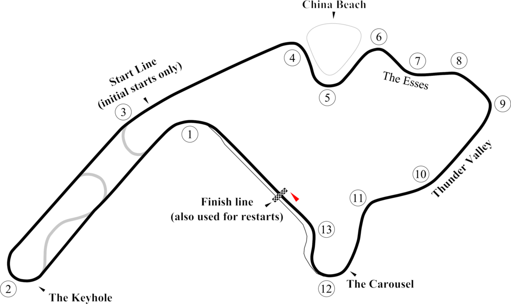
English: Version of
Image:Mid-Ohio.svg for browsers like IE7 that don't support SVG. |
| Date | |
| Source | Own work |
| Author | Will Pittenger |
| Other versions |
 |
| Camera location |
| View this and other nearby images on: OpenStreetMap |
|
|---|
Licensing
| I, the copyright holder of this work, release this work into the
public domain. This applies worldwide. In some countries this may not be legally possible; if so: I grant anyone the right to use this work for any purpose, without any conditions, unless such conditions are required by law. |
File history
Click on a date/time to view the file as it appeared at that time.
| Date/Time | Thumbnail | Dimensions | User | Comment | |
|---|---|---|---|---|---|
| current | 23:26, 18 October 2009 |
| 3,086 × 1,838 (515 KB) | Spyder Monkey | bypassed keyhole chicane |
| 07:30, 30 June 2008 |
 | 3,086 × 1,838 (514 KB) | Will Pittenger | New version puts circle around Turn 1. | |
| 07:13, 30 June 2008 |
 | 3,086 × 1,838 (511 KB) | Will Pittenger | {{Information |Description={{en|1=Version of Image:Mid-Ohio.svg for browsers like IE7 that don't support SVG.}} |Source=Own work by uploader |Author= Will Pittenger |Date=6-30-2008 |Permission= |other_versions=[[Image:Mid-Ohio. |
File usage
The following pages on the English Wikipedia use this file (pages on other projects are not listed):
Global file usage
The following other wikis use this file:
- Usage on es.wikipedia.org
- Usage on fr.wikipedia.org
- Usage on id.wikipedia.org
- Usage on lv.wikipedia.org
- Usage on pt.wikipedia.org
Metadata
Size of this preview:
800 × 476 pixels. Other resolutions:
320 × 191 pixels |
640 × 381 pixels |
1,024 × 610 pixels |
1,280 × 762 pixels |
3,086 × 1,838 pixels.
Original file (3,086 × 1,838 pixels, file size: 515 KB, MIME type: image/png)
| This is a file from the
Wikimedia Commons. Information from its
description page there is shown below. Commons is a freely licensed media file repository. You can help. |
Summary
| Description |
English: Version of
Image:Mid-Ohio.svg for browsers like IE7 that don't support SVG. |
| Date | |
| Source | Own work |
| Author | Will Pittenger |
| Other versions |
|
| Camera location |
| View this and other nearby images on: OpenStreetMap |
|
|---|
Licensing
| I, the copyright holder of this work, release this work into the
public domain. This applies worldwide. In some countries this may not be legally possible; if so: I grant anyone the right to use this work for any purpose, without any conditions, unless such conditions are required by law. |
File history
Click on a date/time to view the file as it appeared at that time.
| Date/Time | Thumbnail | Dimensions | User | Comment | |
|---|---|---|---|---|---|
| current | 23:26, 18 October 2009 |
| 3,086 × 1,838 (515 KB) | Spyder Monkey | bypassed keyhole chicane |
| 07:30, 30 June 2008 |
| 3,086 × 1,838 (514 KB) | Will Pittenger | New version puts circle around Turn 1. | |
| 07:13, 30 June 2008 |
| 3,086 × 1,838 (511 KB) | Will Pittenger | {{Information |Description={{en|1=Version of Image:Mid-Ohio.svg for browsers like IE7 that don't support SVG.}} |Source=Own work by uploader |Author= Will Pittenger |Date=6-30-2008 |Permission= |other_versions=[[Image:Mid-Ohio. |
File usage
The following pages on the English Wikipedia use this file (pages on other projects are not listed):
Global file usage
The following other wikis use this file:
- Usage on es.wikipedia.org
- Usage on fr.wikipedia.org
- Usage on id.wikipedia.org
- Usage on lv.wikipedia.org
- Usage on pt.wikipedia.org