
Original file (SVG file, nominally 1,231 × 1,305 pixels, file size: 1.3 MB)
| This is a file from the
Wikimedia Commons. Information from its
description page there is shown below. Commons is a freely licensed media file repository. You can help. |
| Description |
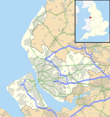
Map of Merseyside, UK with the following information shown:
Equirectangular map projection on WGS 84 datum, with N/S stretched 165% Geographic limits:
|
| Date | |
| Source |
|
| Author | Nilfanion, created using Ordnance Survey data |
| Permission ( Reusing this file) |
This file is licensed under the
Creative Commons
Attribution-Share Alike 3.0 Unported license. Attribution: Contains Ordnance Survey data © Crown copyright and database right
|
| Other versions | File:Bedfordshire UK district map (blank).svg - Blank map |
.svg)
File history
Click on a date/time to view the file as it appeared at that time.
| Date/Time | Thumbnail | Dimensions | User | Comment | |
|---|---|---|---|---|---|
| current | 19:01, 26 September 2010 |
| 1,231 × 1,305 (1.3 MB) | Nilfanion | {{Information |Description=Map of Merseyside, UK with the following information shown: *Administrative borders *Coastline, lakes and rivers *Roads and railways *Urban areas Equirectangular map projection on WGS 84 datum, with N/S stretche |
File usage
More than 100 pages use this file. The following list shows the first 100 pages that use this file only. A full list is available.
- Aigburth
- Ainsdale
- Aintree
- Allerton, Liverpool
- Anfield (suburb)
- Bebington
- Bidston
- Birkdale
- Birkenhead
- Blowick
- Bootle
- Bramley-Moore Dock
- Bromborough
- Childwall
- Church of Our Lady and Saint Nicholas, Liverpool
- Churchtown, Merseyside
- Clock Face, St Helens
- Clubmoor
- Crosby, Merseyside
- Crossens
- Croxteth
- Dingle, Liverpool
- Earlestown
- Eastham, Merseyside
- Edge Hill, Liverpool
- Everton, Liverpool
- Fazakerley
- Formby
- Fort Perch Rock
- Freshfield
- Garston, Liverpool
- Grassendale
- Great Crosby
- Halewood
- Haydock
- Heswall
- Hightown, Merseyside
- Hoylake
- Hunt's Cross
- Huyton
- Ince Blundell
- Irby, Merseyside
- Kirkby
- Knotty Ash
- Leasowe
- Liscard
- Litherland
- Little Altcar
- Little Crosby
- Liverpool Castle
- Liverpool Empire Theatre
- Liverpool John Lennon Airport
- Liverpool Playhouse
- Liverpool Royal Infirmary
- Lunt
- Lydiate
- Maghull
- Marshside, Merseyside
- Melling, Merseyside
- Meols
- Moreton, Merseyside
- Mossley Hill
- Nelson Dock, Liverpool
- Netherley, Liverpool
- Netherton, Merseyside
- New Ferry
- Newton-le-Willows
- Norris Green
- North Wirral Coastal Park
- Old Swan
- Oxton, Merseyside
- Pensby
- Philharmonic Dining Rooms
- Port Sunlight
- Prescot
- Prescot Parish Church
- RAF Woodvale
- Rainford
- Rainhill
- Roby, Merseyside
- Royal Liverpool University Hospital
- Seacombe
- Sefton, Merseyside
- Southport
- Speke
- Speke Hall
- St Helens, Merseyside
- St Michael's Hamlet
- Switch Island
- Thingwall
- Thornton, Merseyside
- Toxteth
- Tranmere, Merseyside
- Tuebrook
- Upton, Merseyside
- Wallasey
- Walton, Liverpool
- Waterloo, Merseyside
- Wavertree
- West Derby
View more links to this file.
Global file usage
The following other wikis use this file:
- Usage on ar.wikipedia.org
- Usage on ast.wikipedia.org
- Usage on bg.wikipedia.org
- Usage on br.wikipedia.org
- Usage on ceb.wikipedia.org
- Usage on es.wikipedia.org
- Liverpool
- Aeropuerto de Liverpool-John Lennon
- Saint Helens (Merseyside)
- Kirkdale
- Gayton (Merseyside)
- Plantilla:Mapa de localización de Merseyside
- Bebington
- Birkenhead
- Wallasey
- Southport
- Vauxhall (Liverpool)
- Hoylake
- West Kirby
- Galería de Arte Walker
- Barnston (Merseyside)
- Haydock
- Heswall
- Hightown
- Billinge
- Litherland
- Kirkby
- Maghull
- Bootle
- Newton-le-Willows
- Rainford Junction
- Rainford
- Prescot
- Rainhill
- Anfield (barrio)
- Usage on fa.wikipedia.org
View more global usage of this file.
Metadata
Original file (SVG file, nominally 1,231 × 1,305 pixels, file size: 1.3 MB)
| This is a file from the
Wikimedia Commons. Information from its
description page there is shown below. Commons is a freely licensed media file repository. You can help. |
| Description |
Map of Merseyside, UK with the following information shown:
Equirectangular map projection on WGS 84 datum, with N/S stretched 165% Geographic limits:
|
| Date | |
| Source |
|
| Author | Nilfanion, created using Ordnance Survey data |
| Permission ( Reusing this file) |
This file is licensed under the
Creative Commons
Attribution-Share Alike 3.0 Unported license. Attribution: Contains Ordnance Survey data © Crown copyright and database right
|
| Other versions | File:Bedfordshire UK district map (blank).svg - Blank map |
File history
Click on a date/time to view the file as it appeared at that time.
| Date/Time | Thumbnail | Dimensions | User | Comment | |
|---|---|---|---|---|---|
| current | 19:01, 26 September 2010 |
| 1,231 × 1,305 (1.3 MB) | Nilfanion | {{Information |Description=Map of Merseyside, UK with the following information shown: *Administrative borders *Coastline, lakes and rivers *Roads and railways *Urban areas Equirectangular map projection on WGS 84 datum, with N/S stretche |
File usage
More than 100 pages use this file. The following list shows the first 100 pages that use this file only. A full list is available.
- Aigburth
- Ainsdale
- Aintree
- Allerton, Liverpool
- Anfield (suburb)
- Bebington
- Bidston
- Birkdale
- Birkenhead
- Blowick
- Bootle
- Bramley-Moore Dock
- Bromborough
- Childwall
- Church of Our Lady and Saint Nicholas, Liverpool
- Churchtown, Merseyside
- Clock Face, St Helens
- Clubmoor
- Crosby, Merseyside
- Crossens
- Croxteth
- Dingle, Liverpool
- Earlestown
- Eastham, Merseyside
- Edge Hill, Liverpool
- Everton, Liverpool
- Fazakerley
- Formby
- Fort Perch Rock
- Freshfield
- Garston, Liverpool
- Grassendale
- Great Crosby
- Halewood
- Haydock
- Heswall
- Hightown, Merseyside
- Hoylake
- Hunt's Cross
- Huyton
- Ince Blundell
- Irby, Merseyside
- Kirkby
- Knotty Ash
- Leasowe
- Liscard
- Litherland
- Little Altcar
- Little Crosby
- Liverpool Castle
- Liverpool Empire Theatre
- Liverpool John Lennon Airport
- Liverpool Playhouse
- Liverpool Royal Infirmary
- Lunt
- Lydiate
- Maghull
- Marshside, Merseyside
- Melling, Merseyside
- Meols
- Moreton, Merseyside
- Mossley Hill
- Nelson Dock, Liverpool
- Netherley, Liverpool
- Netherton, Merseyside
- New Ferry
- Newton-le-Willows
- Norris Green
- North Wirral Coastal Park
- Old Swan
- Oxton, Merseyside
- Pensby
- Philharmonic Dining Rooms
- Port Sunlight
- Prescot
- Prescot Parish Church
- RAF Woodvale
- Rainford
- Rainhill
- Roby, Merseyside
- Royal Liverpool University Hospital
- Seacombe
- Sefton, Merseyside
- Southport
- Speke
- Speke Hall
- St Helens, Merseyside
- St Michael's Hamlet
- Switch Island
- Thingwall
- Thornton, Merseyside
- Toxteth
- Tranmere, Merseyside
- Tuebrook
- Upton, Merseyside
- Wallasey
- Walton, Liverpool
- Waterloo, Merseyside
- Wavertree
- West Derby
View more links to this file.
Global file usage
The following other wikis use this file:
- Usage on ar.wikipedia.org
- Usage on ast.wikipedia.org
- Usage on bg.wikipedia.org
- Usage on br.wikipedia.org
- Usage on ceb.wikipedia.org
- Usage on es.wikipedia.org
- Liverpool
- Aeropuerto de Liverpool-John Lennon
- Saint Helens (Merseyside)
- Kirkdale
- Gayton (Merseyside)
- Plantilla:Mapa de localización de Merseyside
- Bebington
- Birkenhead
- Wallasey
- Southport
- Vauxhall (Liverpool)
- Hoylake
- West Kirby
- Galería de Arte Walker
- Barnston (Merseyside)
- Haydock
- Heswall
- Hightown
- Billinge
- Litherland
- Kirkby
- Maghull
- Bootle
- Newton-le-Willows
- Rainford Junction
- Rainford
- Prescot
- Rainhill
- Anfield (barrio)
- Usage on fa.wikipedia.org
View more global usage of this file.