
Original file (3,509 × 1,383 pixels, file size: 494 KB, MIME type: image/jpeg)
| This is a file from the
Wikimedia Commons. Information from its
description page there is shown below. Commons is a freely licensed media file repository. You can help. |
Summary
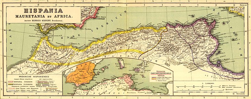
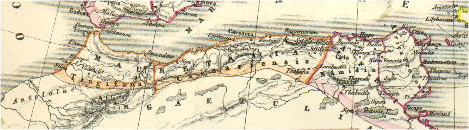
Bron:
http://www.gottwein.de/latine/map/imp01_afr_nw.jpg
Autor: H.Kiepert, Atlas antiquus, Berlin (Reimer) o.J.
Licensing
|
This work is in the public domain in its country of origin and other countries and areas where the copyright term is the author's life plus 70 years or fewer.
| |
| This file has been identified as being free of known restrictions under copyright law, including all related and neighboring rights. | |
File history
Click on a date/time to view the file as it appeared at that time.
| Date/Time | Thumbnail | Dimensions | User | Comment | |
|---|---|---|---|---|---|
| current | 16:54, 3 January 2011 |
| 3,509 × 1,383 (494 KB) | Profburp | Meilleure définition. Extrait de la carte: Hispania, Mauretania et Africa. (with) Carthago. (with) Provinciae Carthaginiensibus subditae. Auctore Henrico Kiepert Berolinensi. Geographische Verlagshandlung Dietrich Reimer (Ernst Vohsen) Berlin, Wilhemlstr |
| 18:23, 13 May 2006 |
| 1,638 × 454 (175 KB) | Rodriguillo | {{nl|Uit: H.Kiepert, Atlas antiquus, Berlin (Reimer) o.J. Bron: http://www.gottwein.de/latine/map/imp01_afr_nw.jpg Kaart met de '' provinciae'' Mauretania Tingitana, Mauretania Caesariensis en Numidia.}} {{es|Mapa de las provincias roman |
File usage
Global file usage
The following other wikis use this file:
- Usage on am.wikipedia.org
- Usage on ar.wikipedia.org
- Usage on ary.wikipedia.org
- Usage on ast.wikipedia.org
- Usage on azb.wikipedia.org
- Usage on az.wikipedia.org
- Usage on be.wikipedia.org
- Usage on br.wikipedia.org
- Usage on ca.wikipedia.org
- Usage on ckb.wikipedia.org
- Usage on cs.wikipedia.org
- Usage on cy.wikipedia.org
- Usage on de.wikipedia.org
- Usage on eo.wikipedia.org
- Usage on es.wikipedia.org
- Usage on et.wikipedia.org
- Usage on eu.wikipedia.org
View more global usage of this file.
Metadata
Original file (3,509 × 1,383 pixels, file size: 494 KB, MIME type: image/jpeg)
| This is a file from the
Wikimedia Commons. Information from its
description page there is shown below. Commons is a freely licensed media file repository. You can help. |
Summary
Bron:
http://www.gottwein.de/latine/map/imp01_afr_nw.jpg
Autor: H.Kiepert, Atlas antiquus, Berlin (Reimer) o.J.
Licensing
|
This work is in the public domain in its country of origin and other countries and areas where the copyright term is the author's life plus 70 years or fewer.
| |
| This file has been identified as being free of known restrictions under copyright law, including all related and neighboring rights. | |
File history
Click on a date/time to view the file as it appeared at that time.
| Date/Time | Thumbnail | Dimensions | User | Comment | |
|---|---|---|---|---|---|
| current | 16:54, 3 January 2011 |
| 3,509 × 1,383 (494 KB) | Profburp | Meilleure définition. Extrait de la carte: Hispania, Mauretania et Africa. (with) Carthago. (with) Provinciae Carthaginiensibus subditae. Auctore Henrico Kiepert Berolinensi. Geographische Verlagshandlung Dietrich Reimer (Ernst Vohsen) Berlin, Wilhemlstr |
| 18:23, 13 May 2006 |
| 1,638 × 454 (175 KB) | Rodriguillo | {{nl|Uit: H.Kiepert, Atlas antiquus, Berlin (Reimer) o.J. Bron: http://www.gottwein.de/latine/map/imp01_afr_nw.jpg Kaart met de '' provinciae'' Mauretania Tingitana, Mauretania Caesariensis en Numidia.}} {{es|Mapa de las provincias roman |
File usage
Global file usage
The following other wikis use this file:
- Usage on am.wikipedia.org
- Usage on ar.wikipedia.org
- Usage on ary.wikipedia.org
- Usage on ast.wikipedia.org
- Usage on azb.wikipedia.org
- Usage on az.wikipedia.org
- Usage on be.wikipedia.org
- Usage on br.wikipedia.org
- Usage on ca.wikipedia.org
- Usage on ckb.wikipedia.org
- Usage on cs.wikipedia.org
- Usage on cy.wikipedia.org
- Usage on de.wikipedia.org
- Usage on eo.wikipedia.org
- Usage on es.wikipedia.org
- Usage on et.wikipedia.org
- Usage on eu.wikipedia.org
View more global usage of this file.