Photos • Location


Size of this preview:
800 × 559 pixels. Other resolutions:
320 × 224 pixels |
640 × 447 pixels |
1,024 × 715 pixels |
1,280 × 894 pixels |
1,500 × 1,048 pixels.
Original file (1,500 × 1,048 pixels, file size: 744 KB, MIME type: image/jpeg)
| This is a file from the
Wikimedia Commons. Information from its
description page there is shown below. Commons is a freely licensed media file repository. You can help. |
| Description |
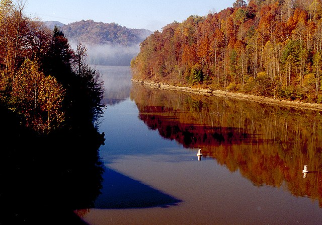
English: Martins Fork Lake in Harlan County, Kentucky, USA. The lake is impounded by Martins Fork Dam, constructed in 1979 by the U.S. Army Corps of Engineers. |
|||
| Date | ||||
| Source |
U.S. Army Corps of Engineers Digital Visual Library Image page Image description page Digital Visual Library home page |
|||
| Author | Bill Peoples, U.S. Army Corps of Engineers | |||
| Permission ( Reusing this file) |
|
|||
| Location | Harlan County, Kentucky, USA |
| Camera location |
| View this and other nearby images on: OpenStreetMap |
|
|---|
File history
Click on a date/time to view the file as it appeared at that time.
| Date/Time | Thumbnail | Dimensions | User | Comment | |
|---|---|---|---|---|---|
| current | 21:19, 31 March 2007 |
| 1,500 × 1,048 (744 KB) | DanMS | {{Information | Description = {{en|Martins Fork Lake in Harlan County, Kentucky, USA. The lake is impounded by Martins Fork Dam, constructed in 1979 by the U.S. Army Corps of Engineers.}} | Source = U.S. Army Corps of Engineers Digital Visual L |
File usage
The following pages on the English Wikipedia use this file (pages on other projects are not listed):
- Bad Branch Falls State Nature Preserve
- Barthell, Kentucky
- Bat Cave and Cascade Caverns State Nature Preserves
- Battle of Middle Creek
- Big Sandy Heritage Center
- Big South Fork National River and Recreation Area
- Big South Fork Scenic Railway
- Black Mountain (Kentucky)
- Black Mountain Off-Road Adventure Area
- Blue Heron, Kentucky
- Breaks Interstate Park
- Buckhorn Lake (Kentucky)
- Buckhorn Lake State Resort Park
- Carr Creek Lake
- Carr Creek State Park
- Carter Caves State Resort Park
- Cave Run Lake
- Coal Miners' Museum (Van Lear)
- Cranks Creek Lake
- Cumberland Falls
- Cumberland Falls State Resort Park
- Cumberland Gap
- Cumberland Gap National Historical Park
- Cumberland Gap Tunnel
- Cumberland Inn & Museum
- Daniel Boone National Forest
- David A. Zegeer Coal-Railroad Museum
- Dawkins Line Rail Trail
- Dewey Lake
- Dewey Lake State Forest
- Dog Slaughter Falls
- Dr. Thomas Walker State Historic Site
- Eagle Falls (Kentucky)
- East Kentucky Science Center
- Eastern Kentucky Coalfield
- Elkhorn City Railroad Museum
- Fishtrap Lake
- Fishtrap Lake State Park
- Francis M. Stafford House
- George Washington and Jefferson National Forests
- Grayson Lake
- Grayson Lake State Park
- Greenbo Lake
- Greenbo Lake State Resort Park
- Harland Sanders Café and Museum
- Hensley Settlement
- Highlands Museum and Discovery Center
- Hindman Settlement School
- Jenny Wiley State Resort Park
- Kentenia State Forest
- Kentucky Coal Museum
- Kentucky Folk Art Center
- Kentucky Ridge State Forest
- Kingdom Come State Park
- Lake Cumberland
- Laurel River Lake
- Levi Jackson Wilderness Road State Park
- List of lakes of Kentucky
- Magoffin County Pioneer Village and Museum
- Martins Fork Lake
- Mayo Mansion
- McCreary County Museum
- Middlesboro crater
- Mountain Homeplace
- Natural Bridge State Resort Park
- Paintsville Lake
- Paintsville Lake State Park
- Pikeville Cut-Through
- Pine Mountain (Appalachian Mountains)
- Pine Mountain State Resort Park
- Pine Mountain State Scenic Trail
- Pound Gap
- Raven Rock (Kentucky)
- Red River Gorge
- Robinson Forest
- Samuel May House
- Sheltowee Trace Trail
- Tri-State Peak
- Tygarts State Forest
- U.S. 23 Country Music Highway Museum
- Yahoo Arch
- Yahoo Falls
- Yatesville Lake State Park
- User:Brendan.Hunstad/draft on Cumberland Gap
- User:Brendan.Hunstad/draft on Pound Gap
- User:Reportingsjr/Red River Gorge
- User:TinterBob007/Lake Cumberland
- Wikipedia:WikiProject Kentucky/Eastern Mountain Coal Fields task force
- Template:EMCF Attractions
- Category:Eastern Kentucky Coalfield
Global file usage
The following other wikis use this file:
- Usage on da.wikipedia.org
- Usage on de.wikipedia.org
- Usage on et.wikipedia.org
- Usage on fa.wikipedia.org
- Usage on fr.wikipedia.org
- Usage on hu.wikipedia.org
- Usage on id.wikipedia.org
- Usage on pl.wikipedia.org
- Usage on ru.wikipedia.org
Metadata
Size of this preview:
800 × 559 pixels. Other resolutions:
320 × 224 pixels |
640 × 447 pixels |
1,024 × 715 pixels |
1,280 × 894 pixels |
1,500 × 1,048 pixels.
Original file (1,500 × 1,048 pixels, file size: 744 KB, MIME type: image/jpeg)
| This is a file from the
Wikimedia Commons. Information from its
description page there is shown below. Commons is a freely licensed media file repository. You can help. |
| Description |
English: Martins Fork Lake in Harlan County, Kentucky, USA. The lake is impounded by Martins Fork Dam, constructed in 1979 by the U.S. Army Corps of Engineers. |
|||
| Date | ||||
| Source |
U.S. Army Corps of Engineers Digital Visual Library Image page Image description page Digital Visual Library home page |
|||
| Author | Bill Peoples, U.S. Army Corps of Engineers | |||
| Permission ( Reusing this file) |
|
|||
| Location | Harlan County, Kentucky, USA |
| Camera location |
| View this and other nearby images on: OpenStreetMap |
|
|---|
File history
Click on a date/time to view the file as it appeared at that time.
| Date/Time | Thumbnail | Dimensions | User | Comment | |
|---|---|---|---|---|---|
| current | 21:19, 31 March 2007 |
| 1,500 × 1,048 (744 KB) | DanMS | {{Information | Description = {{en|Martins Fork Lake in Harlan County, Kentucky, USA. The lake is impounded by Martins Fork Dam, constructed in 1979 by the U.S. Army Corps of Engineers.}} | Source = U.S. Army Corps of Engineers Digital Visual L |
File usage
The following pages on the English Wikipedia use this file (pages on other projects are not listed):
- Bad Branch Falls State Nature Preserve
- Barthell, Kentucky
- Bat Cave and Cascade Caverns State Nature Preserves
- Battle of Middle Creek
- Big Sandy Heritage Center
- Big South Fork National River and Recreation Area
- Big South Fork Scenic Railway
- Black Mountain (Kentucky)
- Black Mountain Off-Road Adventure Area
- Blue Heron, Kentucky
- Breaks Interstate Park
- Buckhorn Lake (Kentucky)
- Buckhorn Lake State Resort Park
- Carr Creek Lake
- Carr Creek State Park
- Carter Caves State Resort Park
- Cave Run Lake
- Coal Miners' Museum (Van Lear)
- Cranks Creek Lake
- Cumberland Falls
- Cumberland Falls State Resort Park
- Cumberland Gap
- Cumberland Gap National Historical Park
- Cumberland Gap Tunnel
- Cumberland Inn & Museum
- Daniel Boone National Forest
- David A. Zegeer Coal-Railroad Museum
- Dawkins Line Rail Trail
- Dewey Lake
- Dewey Lake State Forest
- Dog Slaughter Falls
- Dr. Thomas Walker State Historic Site
- Eagle Falls (Kentucky)
- East Kentucky Science Center
- Eastern Kentucky Coalfield
- Elkhorn City Railroad Museum
- Fishtrap Lake
- Fishtrap Lake State Park
- Francis M. Stafford House
- George Washington and Jefferson National Forests
- Grayson Lake
- Grayson Lake State Park
- Greenbo Lake
- Greenbo Lake State Resort Park
- Harland Sanders Café and Museum
- Hensley Settlement
- Highlands Museum and Discovery Center
- Hindman Settlement School
- Jenny Wiley State Resort Park
- Kentenia State Forest
- Kentucky Coal Museum
- Kentucky Folk Art Center
- Kentucky Ridge State Forest
- Kingdom Come State Park
- Lake Cumberland
- Laurel River Lake
- Levi Jackson Wilderness Road State Park
- List of lakes of Kentucky
- Magoffin County Pioneer Village and Museum
- Martins Fork Lake
- Mayo Mansion
- McCreary County Museum
- Middlesboro crater
- Mountain Homeplace
- Natural Bridge State Resort Park
- Paintsville Lake
- Paintsville Lake State Park
- Pikeville Cut-Through
- Pine Mountain (Appalachian Mountains)
- Pine Mountain State Resort Park
- Pine Mountain State Scenic Trail
- Pound Gap
- Raven Rock (Kentucky)
- Red River Gorge
- Robinson Forest
- Samuel May House
- Sheltowee Trace Trail
- Tri-State Peak
- Tygarts State Forest
- U.S. 23 Country Music Highway Museum
- Yahoo Arch
- Yahoo Falls
- Yatesville Lake State Park
- User:Brendan.Hunstad/draft on Cumberland Gap
- User:Brendan.Hunstad/draft on Pound Gap
- User:Reportingsjr/Red River Gorge
- User:TinterBob007/Lake Cumberland
- Wikipedia:WikiProject Kentucky/Eastern Mountain Coal Fields task force
- Template:EMCF Attractions
- Category:Eastern Kentucky Coalfield
Global file usage
The following other wikis use this file:
- Usage on da.wikipedia.org
- Usage on de.wikipedia.org
- Usage on et.wikipedia.org
- Usage on fa.wikipedia.org
- Usage on fr.wikipedia.org
- Usage on hu.wikipedia.org
- Usage on id.wikipedia.org
- Usage on pl.wikipedia.org
- Usage on ru.wikipedia.org