Photos • Location


Size of this preview:
800 × 458 pixels. Other resolutions:
320 × 183 pixels |
640 × 367 pixels |
1,024 × 587 pixels |
1,280 × 733 pixels |
2,560 × 1,466 pixels |
5,000 × 2,864 pixels.
Original file (5,000 × 2,864 pixels, file size: 9.7 MB, MIME type: image/jpeg)
| This is a file from the
Wikimedia Commons. Information from its
description page there is shown below. Commons is a freely licensed media file repository. You can help. |
Summary
| Description |
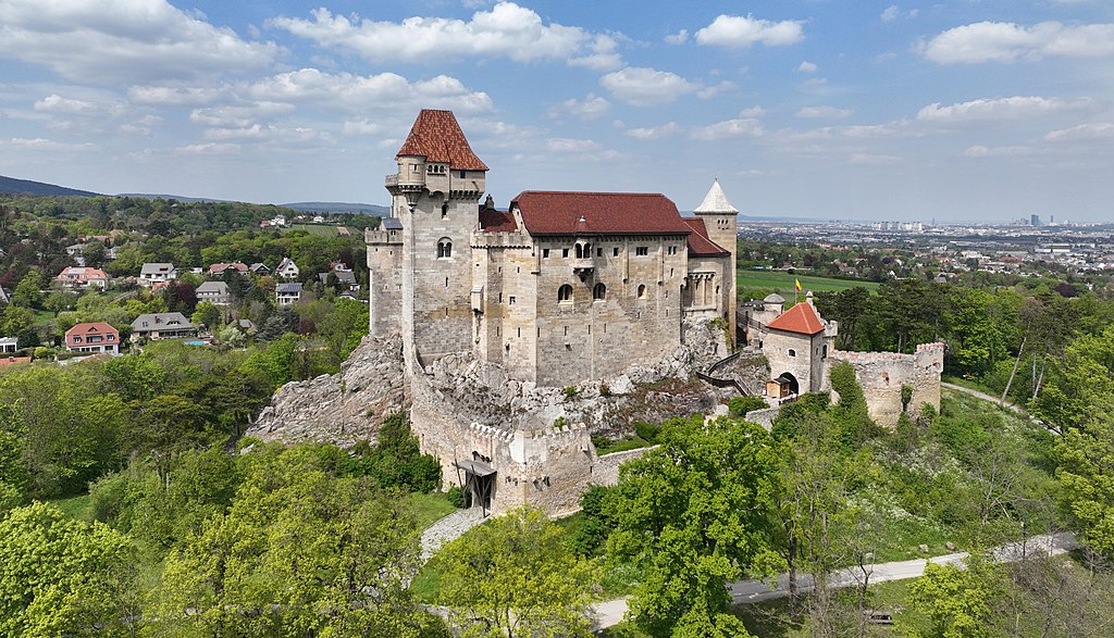
Deutsch: Südansicht der
Burg Liechtenstein in der niederösterreichischen Marktgemeinde
Maria Enzersdorf.
Eine weithin sichtbare und hoch aufragende mächtige romanische Burg, die bis ins 17. Jahrhundert mehrfach verändert, erweitert bzw. nach Zerstörungen wiederaufgebaut wurde. Bei der Türkenbelagerung 1683 wurde sie stark beschädigt und war anschließend eine Ruine, die erst ab dem Anfang des 19. Jahrhundert durch Fürst Johann I. Joseph von und zu Liechtenstein unter Einbeziehung der mittelalterlichen Anlage wiederaufgebaut bzw. rekonstruiert und erweitert wurde. English: South view of Liechtenstein Castle in Maria Enzersdorf, Lower Austria. |
| Date | |
| Source | Own work |
| Author | C.Stadler/Bwag |
| Permission ( Reusing this file) |
Deutsch: Hallo, du darfst mein Foto kostenlos nutzen, aber nenne mich bitte als Fotograf, beispielsweise „Foto: C.Stadler/Bwag“ oder © C.Stadler/Bwag; CC-BY-SA-4.0. Auf mehr Angaben bestehe ich nicht - im Gegensatz zu manch anderen, die die Vorgaben der unten angeführten Lizenzierung auf Punkt und Beistrich einfordern. English: Feel free to use my photos, but please mention me as the author like © C.Stadler/Bwag or © C.Stadler/Bwag; CC-BY-SA-4.0 (that's good enough) and if you want send me a message: bwag@gmx.net. |
| Other versions |
|
.JPG)
.JPG)
.JPG)
| Object location |
| View this and other nearby images on: OpenStreetMap |
|
|---|
.JPG¶ms=048.092620_N_0016.270440_E_globe:Earth_class:object_type:object__&language=en)
| Camera location | | View this and other nearby images on: OpenStreetMap |
|
|---|
.JPG¶ms=048.091750_N_0016.270220_E_globe:Earth_type:camera_heading:3.00&language=en)
Licensing
I, the copyright holder of this work, hereby publish it under the following license:
This file is licensed under the
Creative Commons
Attribution-Share Alike 4.0 International license.
- You are free:
- to share – to copy, distribute and transmit the work
- to remix – to adapt the work
- Under the following conditions:
- attribution – You must give appropriate credit, provide a link to the license, and indicate if changes were made. You may do so in any reasonable manner, but not in any way that suggests the licensor endorses you or your use.
- share alike – If you remix, transform, or build upon the material, you must distribute your contributions under the same or compatible license as the original.
File history
Click on a date/time to view the file as it appeared at that time.
| Date/Time | Thumbnail | Dimensions | User | Comment | |
|---|---|---|---|---|---|
| current | 08:42, 30 April 2022 |
| 5,000 × 2,864 (9.7 MB) | Bwag | {{Information |Description= {{de|1= Südansicht der Burg Liechtenstein in der niederösterreichischen Marktgemeinde Maria Enzersdorf.<br/>Eine weithin sichtbare und hoch aufragende mächtige romanische Burg, die bis ins 17. Jahrhundert mehrfach verändert, erweitert bzw. nach Zerstörungen wiederaufgebaut wurde. Bei der Türkenbelagerung 1683 wurde sie stark beschädigt und war anschließend eine Ruine, die erst ab dem Anfang des 19. Jahrhundert du... |
File usage
The following pages on the English Wikipedia use this file (pages on other projects are not listed):
Global file usage
The following other wikis use this file:
- Usage on cs.wikipedia.org
- Usage on de.wikipedia.org
- Usage on hu.wikipedia.org
- Usage on id.wikipedia.org
- Usage on it.wikipedia.org
- Usage on nl.wikipedia.org
- Usage on pl.wikipedia.org
- Usage on sl.wikipedia.org
- Usage on tr.wikipedia.org
- Usage on www.wikidata.org
Metadata
.JPG)
Size of this preview:
800 × 458 pixels. Other resolutions:
320 × 183 pixels |
640 × 367 pixels |
1,024 × 587 pixels |
1,280 × 733 pixels |
2,560 × 1,466 pixels |
5,000 × 2,864 pixels.
Original file (5,000 × 2,864 pixels, file size: 9.7 MB, MIME type: image/jpeg)
| This is a file from the
Wikimedia Commons. Information from its
description page there is shown below. Commons is a freely licensed media file repository. You can help. |
Summary
| Description |
Deutsch: Südansicht der
Burg Liechtenstein in der niederösterreichischen Marktgemeinde
Maria Enzersdorf.
Eine weithin sichtbare und hoch aufragende mächtige romanische Burg, die bis ins 17. Jahrhundert mehrfach verändert, erweitert bzw. nach Zerstörungen wiederaufgebaut wurde. Bei der Türkenbelagerung 1683 wurde sie stark beschädigt und war anschließend eine Ruine, die erst ab dem Anfang des 19. Jahrhundert durch Fürst Johann I. Joseph von und zu Liechtenstein unter Einbeziehung der mittelalterlichen Anlage wiederaufgebaut bzw. rekonstruiert und erweitert wurde. English: South view of Liechtenstein Castle in Maria Enzersdorf, Lower Austria. |
| Date | |
| Source | Own work |
| Author | C.Stadler/Bwag |
| Permission ( Reusing this file) |
Deutsch: Hallo, du darfst mein Foto kostenlos nutzen, aber nenne mich bitte als Fotograf, beispielsweise „Foto: C.Stadler/Bwag“ oder © C.Stadler/Bwag; CC-BY-SA-4.0. Auf mehr Angaben bestehe ich nicht - im Gegensatz zu manch anderen, die die Vorgaben der unten angeführten Lizenzierung auf Punkt und Beistrich einfordern. English: Feel free to use my photos, but please mention me as the author like © C.Stadler/Bwag or © C.Stadler/Bwag; CC-BY-SA-4.0 (that's good enough) and if you want send me a message: bwag@gmx.net. |
| Other versions |
|
| Object location |
| View this and other nearby images on: OpenStreetMap |
|
|---|
| Camera location | | View this and other nearby images on: OpenStreetMap |
|
|---|
Licensing
I, the copyright holder of this work, hereby publish it under the following license:
This file is licensed under the
Creative Commons
Attribution-Share Alike 4.0 International license.
- You are free:
- to share – to copy, distribute and transmit the work
- to remix – to adapt the work
- Under the following conditions:
- attribution – You must give appropriate credit, provide a link to the license, and indicate if changes were made. You may do so in any reasonable manner, but not in any way that suggests the licensor endorses you or your use.
- share alike – If you remix, transform, or build upon the material, you must distribute your contributions under the same or compatible license as the original.
File history
Click on a date/time to view the file as it appeared at that time.
| Date/Time | Thumbnail | Dimensions | User | Comment | |
|---|---|---|---|---|---|
| current | 08:42, 30 April 2022 |
| 5,000 × 2,864 (9.7 MB) | Bwag | {{Information |Description= {{de|1= Südansicht der Burg Liechtenstein in der niederösterreichischen Marktgemeinde Maria Enzersdorf.<br/>Eine weithin sichtbare und hoch aufragende mächtige romanische Burg, die bis ins 17. Jahrhundert mehrfach verändert, erweitert bzw. nach Zerstörungen wiederaufgebaut wurde. Bei der Türkenbelagerung 1683 wurde sie stark beschädigt und war anschließend eine Ruine, die erst ab dem Anfang des 19. Jahrhundert du... |
File usage
The following pages on the English Wikipedia use this file (pages on other projects are not listed):
Global file usage
The following other wikis use this file:
- Usage on cs.wikipedia.org
- Usage on de.wikipedia.org
- Usage on hu.wikipedia.org
- Usage on id.wikipedia.org
- Usage on it.wikipedia.org
- Usage on nl.wikipedia.org
- Usage on pl.wikipedia.org
- Usage on sl.wikipedia.org
- Usage on tr.wikipedia.org
- Usage on www.wikidata.org