Size of this preview:
471 × 599 pixels. Other resolutions:
188 × 240 pixels |
377 × 480 pixels |
603 × 768 pixels |
804 × 1,024 pixels |
1,609 × 2,048 pixels |
3,300 × 4,200 pixels.
Original file (3,300 × 4,200 pixels, file size: 5.52 MB, MIME type: image/jpeg)
| This is a file from the
Wikimedia Commons. Information from its
description page there is shown below. Commons is a freely licensed media file repository. You can help. |
.jpg)
Summary
| Description |
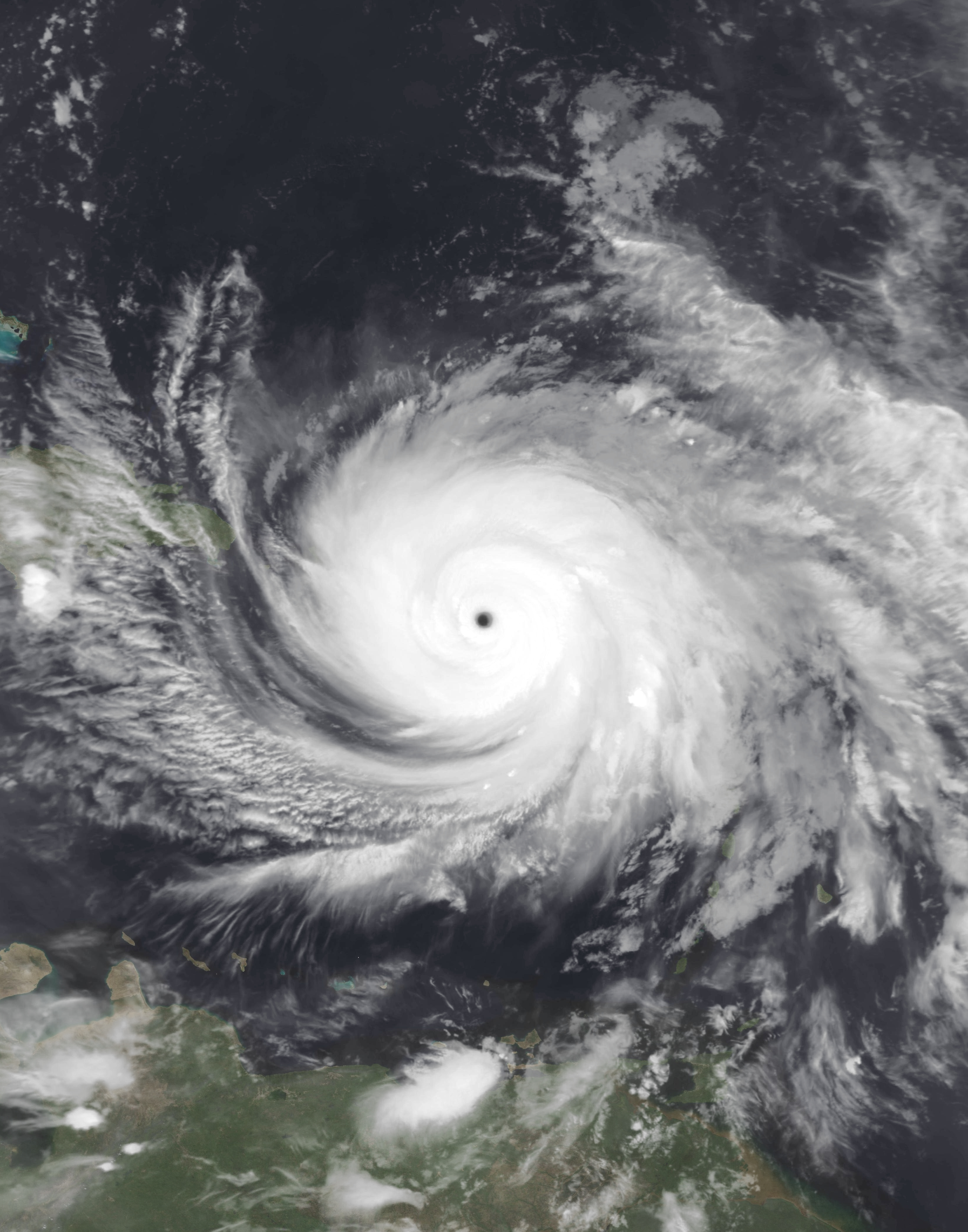
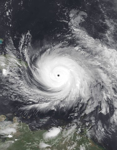
English: This infrared composite representation of Hurricane Maria was captured during the night of September 19, 2017, at 10:38 P.M. Puerto Rico Local Time (02:38 UTC on September 20), employing the Moderate Resolution Imaging Spectroradiometer (MODIS) instrument aboard the polar orbiting Terra satellite launched by NASA in December 1999, the satellite and its instrumentation serve to monitor meteorological phenomena like Maria. Hurricane Maria, a formidable and expansive cyclone, emerged from an invest area within the primary development zone of the Atlantic Ocean during the 2017 Atlantic hurricane season. At the time of imaging, the storm exhibited peak intensity strength, boasting maximum sustained winds of 175 mph (282 km/h) (150 knots) on the 1-minute Saffir-Simpson scale, classifying it as an extraordinarily powerful Category 5 major hurricane. Its minimum central pressure hovered at 908 mbar (26.8 inHg), Maria proceeded to devastate Puerto Rico, resulting in 2,975 fatalities (3,059 total fatalities including other islands and surrounding nations) and causing $91.6 billion in damages. This places it as the fourth (third at the time) most expensive tropical cyclone in history, following behind Katrina in 2005, Harvey earlier in the same season, and Ian which occurred five years later in 2022. |
| Date | |
| Source | https://worldview.earthdata.nasa.gov |
| Author | NASA Worldview |
Licensing
| This file is in the public domain in the United States because it was solely created by NASA. NASA copyright policy states that "NASA material is not protected by copyright unless noted". (See Template:PD-USGov, NASA copyright policy page or JPL Image Use Policy.) | ||
 |
Warnings:
|
File history
Click on a date/time to view the file as it appeared at that time.
| Date/Time | Thumbnail | Dimensions | User | Comment | |
|---|---|---|---|---|---|
| current | 23:04, 25 April 2024 |
| 3,300 × 4,200 (5.52 MB) | TheWxResearcher | enhanced |
| 17:33, 26 May 2021 |
 | 3,136 × 3,136 (3 MB) | HikingHurricane | Reverted to version as of 01:12, 25 April 2018 (UTC) unnecessary | |
| 16:31, 25 May 2021 |
 | 3,136 × 2,754 (3.26 MB) | Super Cyclonic Storm Corona | Cropped 12 % vertically using CropTool with precise mode. | |
| 01:12, 25 April 2018 |
 | 3,136 × 3,136 (3 MB) | Saxitoxin | User created page with UploadWizard |
File usage
The following pages on the English Wikipedia use this file (pages on other projects are not listed):
Global file usage
The following other wikis use this file:
- Usage on pt.wikipedia.org
Metadata
.jpg)
Size of this preview:
471 × 599 pixels. Other resolutions:
188 × 240 pixels |
377 × 480 pixels |
603 × 768 pixels |
804 × 1,024 pixels |
1,609 × 2,048 pixels |
3,300 × 4,200 pixels.
Original file (3,300 × 4,200 pixels, file size: 5.52 MB, MIME type: image/jpeg)
| This is a file from the
Wikimedia Commons. Information from its
description page there is shown below. Commons is a freely licensed media file repository. You can help. |
Summary
| Description |
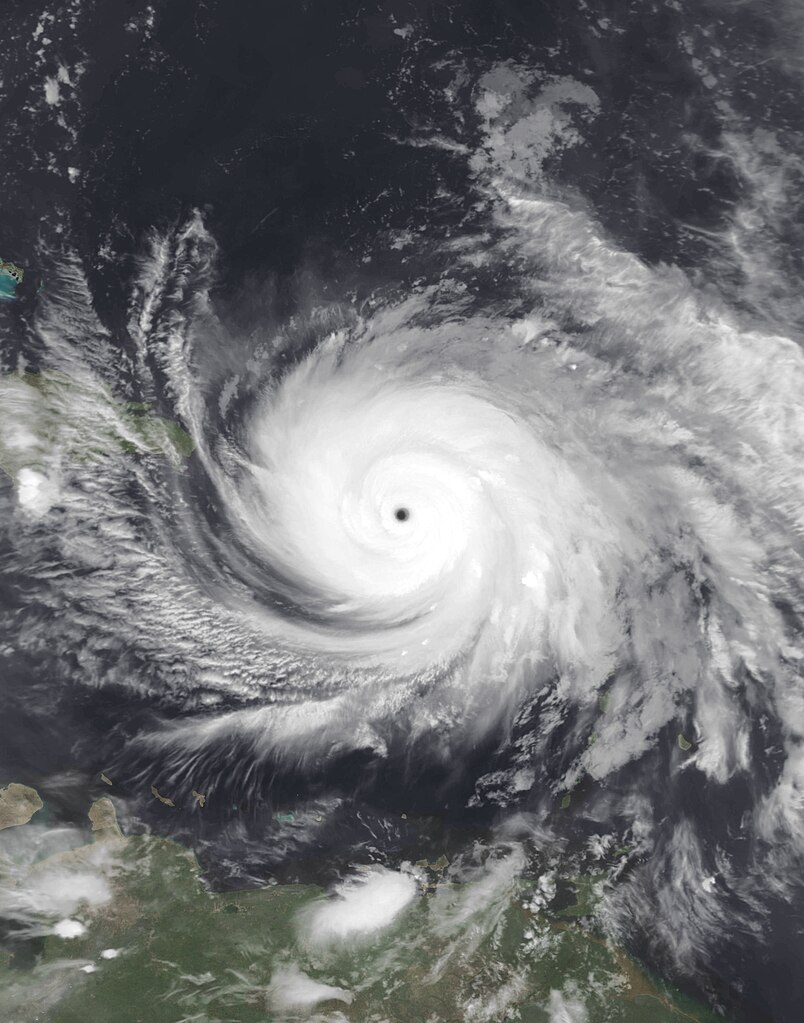
English: This infrared composite representation of Hurricane Maria was captured during the night of September 19, 2017, at 10:38 P.M. Puerto Rico Local Time (02:38 UTC on September 20), employing the Moderate Resolution Imaging Spectroradiometer (MODIS) instrument aboard the polar orbiting Terra satellite launched by NASA in December 1999, the satellite and its instrumentation serve to monitor meteorological phenomena like Maria. Hurricane Maria, a formidable and expansive cyclone, emerged from an invest area within the primary development zone of the Atlantic Ocean during the 2017 Atlantic hurricane season. At the time of imaging, the storm exhibited peak intensity strength, boasting maximum sustained winds of 175 mph (282 km/h) (150 knots) on the 1-minute Saffir-Simpson scale, classifying it as an extraordinarily powerful Category 5 major hurricane. Its minimum central pressure hovered at 908 mbar (26.8 inHg), Maria proceeded to devastate Puerto Rico, resulting in 2,975 fatalities (3,059 total fatalities including other islands and surrounding nations) and causing $91.6 billion in damages. This places it as the fourth (third at the time) most expensive tropical cyclone in history, following behind Katrina in 2005, Harvey earlier in the same season, and Ian which occurred five years later in 2022. |
| Date | |
| Source | https://worldview.earthdata.nasa.gov |
| Author | NASA Worldview |
Licensing
| This file is in the public domain in the United States because it was solely created by NASA. NASA copyright policy states that "NASA material is not protected by copyright unless noted". (See Template:PD-USGov, NASA copyright policy page or JPL Image Use Policy.) | ||
|
Warnings:
|
File history
Click on a date/time to view the file as it appeared at that time.
| Date/Time | Thumbnail | Dimensions | User | Comment | |
|---|---|---|---|---|---|
| current | 23:04, 25 April 2024 |
| 3,300 × 4,200 (5.52 MB) | TheWxResearcher | enhanced |
| 17:33, 26 May 2021 |
| 3,136 × 3,136 (3 MB) | HikingHurricane | Reverted to version as of 01:12, 25 April 2018 (UTC) unnecessary | |
| 16:31, 25 May 2021 |
| 3,136 × 2,754 (3.26 MB) | Super Cyclonic Storm Corona | Cropped 12 % vertically using CropTool with precise mode. | |
| 01:12, 25 April 2018 |
| 3,136 × 3,136 (3 MB) | Saxitoxin | User created page with UploadWizard |
File usage
The following pages on the English Wikipedia use this file (pages on other projects are not listed):
Global file usage
The following other wikis use this file:
- Usage on pt.wikipedia.org