This is a file from the Wikimedia Commons
From Wikipedia, the free encyclopedia

Original file(840 × 716 pixels, file size: 19 KB, MIME type: image/png)

Summary

Description
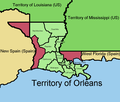
English: A map of the Territory of Orleans, territory of the US, as of 1804
Date
Source Own work
Author Mebigrouxboy

Coast is traced from studies done to examine LA's coast over time

The westernmost portion, West Florida, and the then-disputed Calcasieu area (later known as the Neutral Strip) were seemingly(?) never subdivided into counties

Purple shows disputed area - Yellow/beige is Spain/foreign - Shades of green is US

Westernmost area was a biproduct of the territory's declaration, which stated all land south of the 33rd parallel North and in between Mississippi and Sabine was T of Orleans

Source of the borders of the counties comes from here

Licensing

I, the copyright holder of this work, hereby publish it under the following license:
w:en:Creative Commons
attribution share alike
This file is licensed under the Creative Commons Attribution-Share Alike 4.0 International license.
You are free:
  • to share – to copy, distribute and transmit the work
  • to remix – to adapt the work
Under the following conditions:
  • attribution – You must give appropriate credit, provide a link to the license, and indicate if changes were made. You may do so in any reasonable manner, but not in any way that suggests the licensor endorses you or your use.
  • share alike – If you remix, transform, or build upon the material, you must distribute your contributions under the same or compatible license as the original.

Information

Captions

Add a one-line explanation of what this file represents

Items portrayed in this file

depicts

20 December 2022

image/png

File history

Click on a date/time to view the file as it appeared at that time.

Date/TimeThumbnailDimensionsUserComment
current 01:46, 7 April 2023 Thumbnail for version as of 01:46, 7 April 2023840 × 716 (19 KB)MebigrouxboyNever mind, I got the Spanish claim right last time
01:39, 7 April 2023 Thumbnail for version as of 01:39, 7 April 2023840 × 716 (19 KB)MebigrouxboyConcordia mislabelled as Attakapas, Spanish claim correction
18:39, 20 December 2022 Thumbnail for version as of 18:39, 20 December 2022840 × 716 (20 KB)MebigrouxboyUploaded own work with UploadWizard
The following pages on the English Wikipedia use this file (pages on other projects are not listed):

Global file usage

The following other wikis use this file:

Metadata


Videos

Youtube | Vimeo | Bing

Websites

Google | Yahoo | Bing

Encyclopedia

Google | Yahoo | Bing

Facebook