
Size of this preview:
800 × 552 pixels. Other resolutions:
320 × 221 pixels |
640 × 441 pixels |
1,024 × 706 pixels |
1,280 × 882 pixels |
2,560 × 1,765 pixels |
6,500 × 4,481 pixels.
Original file (6,500 × 4,481 pixels, file size: 11.16 MB, MIME type: image/jpeg)
| This is a file from the
Wikimedia Commons. Information from its
description page there is shown below. Commons is a freely licensed media file repository. You can help. |
Summary
| Description |
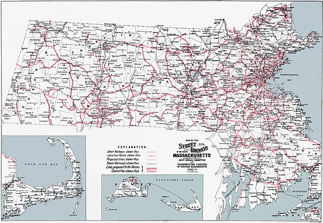
English: Map of the
interurban systems as they existed, or were otherwise proposed, in Massachusetts prior to World War I. Note the density of street railways around urban centers like Boston, Worcester, Springfield, and Pittsfield, in contrast to the lack of railways in the present location of the
Quabbin Reservoir and
Cape Cod. |
||
| Date | |||
| Source | Report of the Joint Special Committee on the Transportation Facilities of Western Massachusetts | ||
| Author | Walter Lithography | ||
| Permission ( Reusing this file) |
|
File history
Click on a date/time to view the file as it appeared at that time.
| Date/Time | Thumbnail | Dimensions | User | Comment | |
|---|---|---|---|---|---|
| current | 05:58, 1 October 2018 |
| 6,500 × 4,481 (11.16 MB) | Simtropolitan | {{Information |description ={{en|1=Map of the {{w|interurban}} systems as they existed, or were otherwise proposed, in Massachusetts prior to World War I. Note the density of street railways around urban centers like Boston, Worcester, Springfield, and Pittsfield, in contrast to the lack of railways in the present location of the {{w|Quabbin Reservoir}} and {{w|Cape Cod}}.}} |date =1913-01 |source =Report of the Joint Special Committee on the Transportation Facilities of Wes... |
File usage
The following pages on the English Wikipedia use this file (pages on other projects are not listed):
Global file usage
The following other wikis use this file:
- Usage on www.wikidata.org
Metadata
Size of this preview:
800 × 552 pixels. Other resolutions:
320 × 221 pixels |
640 × 441 pixels |
1,024 × 706 pixels |
1,280 × 882 pixels |
2,560 × 1,765 pixels |
6,500 × 4,481 pixels.
Original file (6,500 × 4,481 pixels, file size: 11.16 MB, MIME type: image/jpeg)
| This is a file from the
Wikimedia Commons. Information from its
description page there is shown below. Commons is a freely licensed media file repository. You can help. |
Summary
| Description |
English: Map of the
interurban systems as they existed, or were otherwise proposed, in Massachusetts prior to World War I. Note the density of street railways around urban centers like Boston, Worcester, Springfield, and Pittsfield, in contrast to the lack of railways in the present location of the
Quabbin Reservoir and
Cape Cod. |
||
| Date | |||
| Source | Report of the Joint Special Committee on the Transportation Facilities of Western Massachusetts | ||
| Author | Walter Lithography | ||
| Permission ( Reusing this file) |
|
File history
Click on a date/time to view the file as it appeared at that time.
| Date/Time | Thumbnail | Dimensions | User | Comment | |
|---|---|---|---|---|---|
| current | 05:58, 1 October 2018 |
| 6,500 × 4,481 (11.16 MB) | Simtropolitan | {{Information |description ={{en|1=Map of the {{w|interurban}} systems as they existed, or were otherwise proposed, in Massachusetts prior to World War I. Note the density of street railways around urban centers like Boston, Worcester, Springfield, and Pittsfield, in contrast to the lack of railways in the present location of the {{w|Quabbin Reservoir}} and {{w|Cape Cod}}.}} |date =1913-01 |source =Report of the Joint Special Committee on the Transportation Facilities of Wes... |
File usage
The following pages on the English Wikipedia use this file (pages on other projects are not listed):
Global file usage
The following other wikis use this file:
- Usage on www.wikidata.org