Photos • Location


Size of this preview:
337 × 599 pixels. Other resolutions:
135 × 240 pixels |
270 × 480 pixels |
719 × 1,279 pixels.
Original file (719 × 1,279 pixels, file size: 171 KB, MIME type: image/jpeg)
| This is a file from the
Wikimedia Commons. Information from its
description page there is shown below. Commons is a freely licensed media file repository. You can help. |
Summary
| Description |
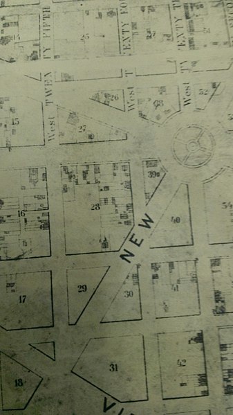
English: Zoomed in section of Albert Boshke's Map of Washington City depicting the location of Snow's Court (Square 28). The streets displayed are 25th, 24th, 23rd, H, I, K, and L. |
| Date | |
| Source | Albert Boshcke's Map of Washington City 1857 |
| Author | Albert Boscke |
| Camera location |
| View this and other nearby images on: OpenStreetMap |
|
|---|
Licensing
This work is in the
public domain in the
United States because it was
published (or registered with the
U.S. Copyright Office) before January 1, 1929.
Public domain works must be out of copyright in both the United States and in the source country of the work in order to be hosted on the Commons. If the work is not a U.S. work, the file must have an additional
copyright tag indicating the copyright status in the source country.
Note: This tag should not be used for sound recordings. |
File history
Click on a date/time to view the file as it appeared at that time.
| Date/Time | Thumbnail | Dimensions | User | Comment | |
|---|---|---|---|---|---|
| current | 18:57, 20 April 2013 |
| 719 × 1,279 (171 KB) | Lanew715 | User created page with UploadWizard |
File usage
The following pages on the English Wikipedia use this file (pages on other projects are not listed):
Metadata
Size of this preview:
337 × 599 pixels. Other resolutions:
135 × 240 pixels |
270 × 480 pixels |
719 × 1,279 pixels.
Original file (719 × 1,279 pixels, file size: 171 KB, MIME type: image/jpeg)
| This is a file from the
Wikimedia Commons. Information from its
description page there is shown below. Commons is a freely licensed media file repository. You can help. |
Summary
| Description |
English: Zoomed in section of Albert Boshke's Map of Washington City depicting the location of Snow's Court (Square 28). The streets displayed are 25th, 24th, 23rd, H, I, K, and L. |
| Date | |
| Source | Albert Boshcke's Map of Washington City 1857 |
| Author | Albert Boscke |
| Camera location |
| View this and other nearby images on: OpenStreetMap |
|
|---|
Licensing
This work is in the
public domain in the
United States because it was
published (or registered with the
U.S. Copyright Office) before January 1, 1929.
Public domain works must be out of copyright in both the United States and in the source country of the work in order to be hosted on the Commons. If the work is not a U.S. work, the file must have an additional
copyright tag indicating the copyright status in the source country.
Note: This tag should not be used for sound recordings. |
File history
Click on a date/time to view the file as it appeared at that time.
| Date/Time | Thumbnail | Dimensions | User | Comment | |
|---|---|---|---|---|---|
| current | 18:57, 20 April 2013 |
| 719 × 1,279 (171 KB) | Lanew715 | User created page with UploadWizard |
File usage
The following pages on the English Wikipedia use this file (pages on other projects are not listed):