No higher resolution available.
Map_of_Pearl_Harbor_attack_force.jpg (753 × 526 pixels, file size: 119 KB, MIME type: image/jpeg)
| This is a file from the
Wikimedia Commons. Information from its
description page there is shown below. Commons is a freely licensed media file repository. You can help. |
Summary
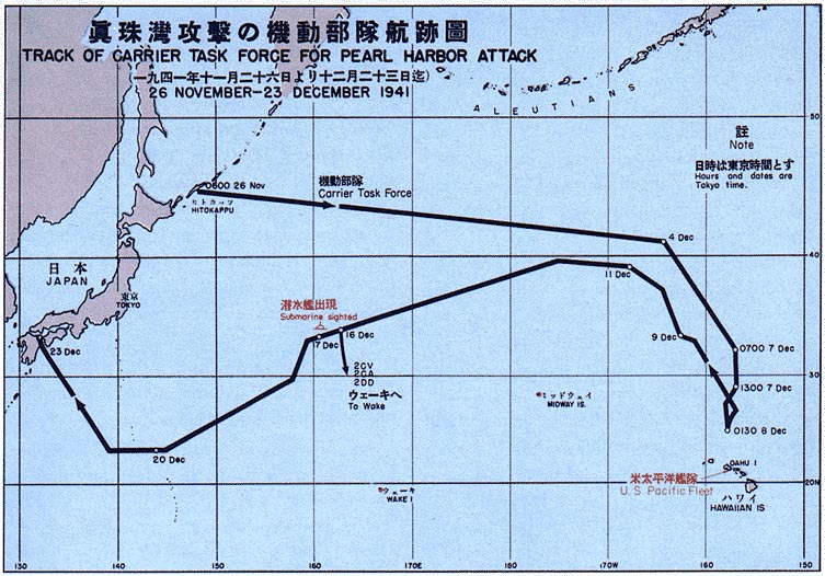
| Description |
English: The routes used by the Japanese fleet to approach and attack Pearl Harbor. |
| Date | |
| Source |
Source: "Reports of General MacArthur" - 1966 Government printing office
|
| Author | United States Army |
| Permission ( Reusing this file) |
PD-AUTHOR; Released into the public domain (by the author). |
| Other versions | File:PearlHarborCarrierChart.jpg |
Licensing
This file is a work of a
U.S. Army soldier or employee, taken or made as part of that person's official duties. As a
work of the
U.S. federal government, it is in the
public domain in the United States.
|
 |
Original upload log
The original description page was
here. All following user names refer to en.wikipedia.
- 2004-07-19 09:34 Raul654 753×526× (121881 bytes)
File history
Click on a date/time to view the file as it appeared at that time.
| Date/Time | Thumbnail | Dimensions | User | Comment | |
|---|---|---|---|---|---|
| current | 19:24, 1 January 2011 |
| 753 × 526 (119 KB) | File Upload Bot (Magnus Manske) | {{BotMoveToCommons|en.wikipedia|year={{subst:CURRENTYEAR}}|month={{subst:CURRENTMONTHNAME}}|day={{subst:CURRENTDAY}}}} {{Information |Description={{en|The routes used by the Japanese fleet to approach and attack Pearl harbor Source: http://maps.library. |
File usage
The following pages on the English Wikipedia use this file (pages on other projects are not listed):
- Attack on Clark Field
- Attack on Pearl Harbor
- Battle of Borneo (1941–1942)
- Battle of Guam (1941)
- Battle of Gurun
- Battle of Hong Kong
- Battle of Jitra
- Battle of Kampar
- Battle of Kota Bharu
- Battle of Kuala Lumpur
- Battle of Prachuap Khiri Khan
- Battle of Wake Island
- Bombing of Rangoon in World War II
- Bombing of Singapore (1941)
- First Bombardment of Midway
- HMS Peterel (1927)
- Japanese invasion of Aparri
- Japanese invasion of Batan Island
- Japanese invasion of Davao
- Japanese invasion of Lamon Bay
- Japanese invasion of Legazpi
- Japanese invasion of Lingayen Gulf
- Japanese invasion of Thailand
- Japanese invasion of Vigan
- Japanese occupation of the Gilbert Islands
- Malayan campaign
- Philippines campaign (1941–1942)
- Shanghai International Settlement
- Shelling of Johnston and Palmyra
- Sinking of Prince of Wales and Repulse
- USS Wake
- Template:Dec41attacks
Metadata
No higher resolution available.
Map_of_Pearl_Harbor_attack_force.jpg (753 × 526 pixels, file size: 119 KB, MIME type: image/jpeg)
| This is a file from the
Wikimedia Commons. Information from its
description page there is shown below. Commons is a freely licensed media file repository. You can help. |
Summary
| Description |
English: The routes used by the Japanese fleet to approach and attack Pearl Harbor. |
| Date | |
| Source |
Source: "Reports of General MacArthur" - 1966 Government printing office
|
| Author | United States Army |
| Permission ( Reusing this file) |
PD-AUTHOR; Released into the public domain (by the author). |
| Other versions | File:PearlHarborCarrierChart.jpg |
Licensing
This file is a work of a
U.S. Army soldier or employee, taken or made as part of that person's official duties. As a
work of the
U.S. federal government, it is in the
public domain in the United States.
|
|
Original upload log
The original description page was
here. All following user names refer to en.wikipedia.
- 2004-07-19 09:34 Raul654 753×526× (121881 bytes)
File history
Click on a date/time to view the file as it appeared at that time.
| Date/Time | Thumbnail | Dimensions | User | Comment | |
|---|---|---|---|---|---|
| current | 19:24, 1 January 2011 |
| 753 × 526 (119 KB) | File Upload Bot (Magnus Manske) | {{BotMoveToCommons|en.wikipedia|year={{subst:CURRENTYEAR}}|month={{subst:CURRENTMONTHNAME}}|day={{subst:CURRENTDAY}}}} {{Information |Description={{en|The routes used by the Japanese fleet to approach and attack Pearl harbor Source: http://maps.library. |
File usage
The following pages on the English Wikipedia use this file (pages on other projects are not listed):
- Attack on Clark Field
- Attack on Pearl Harbor
- Battle of Borneo (1941–1942)
- Battle of Guam (1941)
- Battle of Gurun
- Battle of Hong Kong
- Battle of Jitra
- Battle of Kampar
- Battle of Kota Bharu
- Battle of Kuala Lumpur
- Battle of Prachuap Khiri Khan
- Battle of Wake Island
- Bombing of Rangoon in World War II
- Bombing of Singapore (1941)
- First Bombardment of Midway
- HMS Peterel (1927)
- Japanese invasion of Aparri
- Japanese invasion of Batan Island
- Japanese invasion of Davao
- Japanese invasion of Lamon Bay
- Japanese invasion of Legazpi
- Japanese invasion of Lingayen Gulf
- Japanese invasion of Thailand
- Japanese invasion of Vigan
- Japanese occupation of the Gilbert Islands
- Malayan campaign
- Philippines campaign (1941–1942)
- Shanghai International Settlement
- Shelling of Johnston and Palmyra
- Sinking of Prince of Wales and Repulse
- USS Wake
- Template:Dec41attacks