
Size of this PNG preview of this SVG file:
600 × 600 pixels. Other resolutions:
240 × 240 pixels |
480 × 480 pixels |
768 × 768 pixels |
1,024 × 1,024 pixels |
2,048 × 2,048 pixels.
Original file (SVG file, nominally 1,024 × 1,024 pixels, file size: 15 KB)
| This is a file from the
Wikimedia Commons. Information from its
description page there is shown below. Commons is a freely licensed media file repository. You can help. |
| Description |
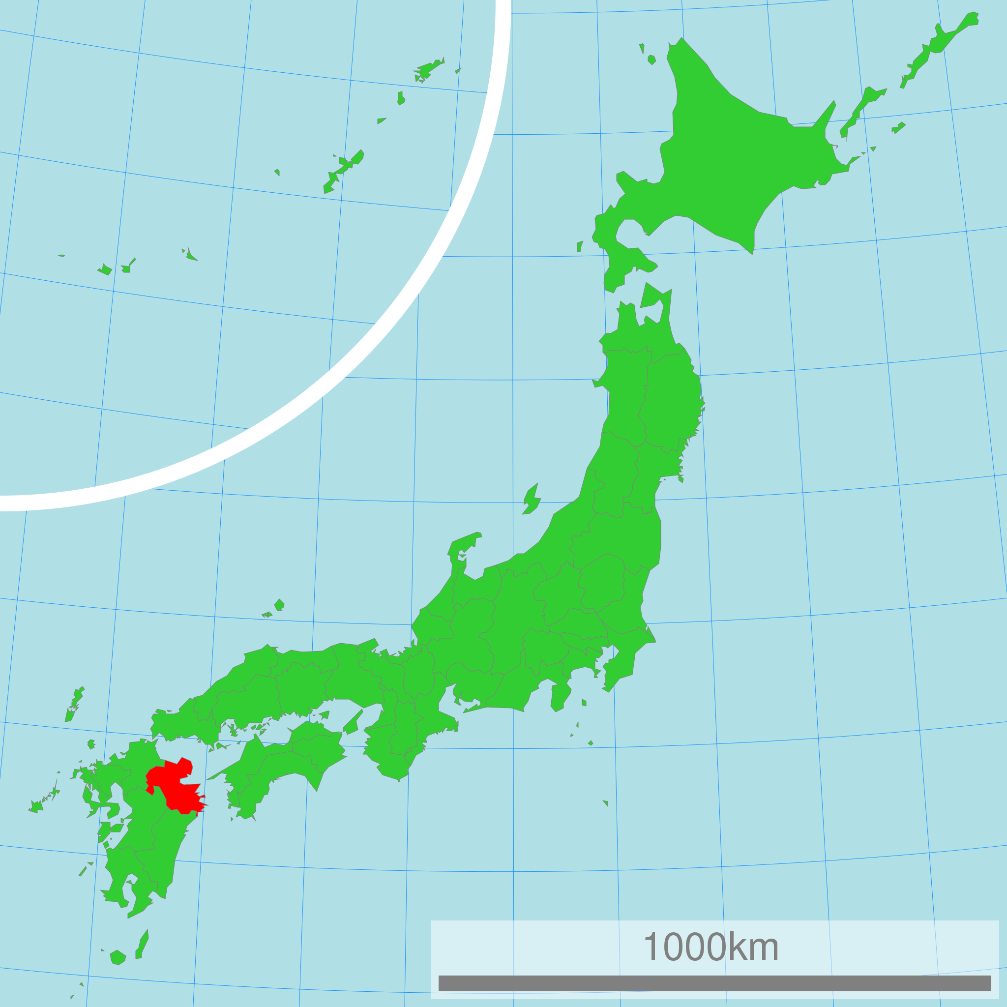
日本語:
大分県の位置図
English: Map of Japan with highlight on Oita-ken |
||||||||
| Source | 国土交通省 国土数値情報(行政区域) | ||||||||
| Author | Lincun | ||||||||
| Permission ( Reusing this file) |
|

Original upload log
| date/time | username | resolution | size | edit summary |
|---|---|---|---|---|
| 16:47, 2 March 2007 | User:Lincun | 1,024×1,024 | 15 KB | <span class="comment">({{都道府県地図情報 |都道府県=大分県 |都道府県Latin=Oita-ken }} )</span> |
File history
Click on a date/time to view the file as it appeared at that time.
| Date/Time | Thumbnail | Dimensions | User | Comment | |
|---|---|---|---|---|---|
| current | 00:55, 16 March 2011 |
| 1,024 × 1,024 (15 KB) | TAKASUGI Shinji | color changes for a better contrast: lightgreen → limegreen deeppink → red |
| 02:22, 21 April 2008 |
 | 1,024 × 1,024 (15 KB) | BetacommandBot | move approved by: User:LERK This image was moved from Image:Map of Japan with highlight on 44 Oita 大分県.svg {{User:Lincun/都道府県地図情報 |都道府県=大分県 |都道府県Latin=Oita-ken }} [[Category:Maps of Oita prefecture] |
File usage
The following pages on the English Wikipedia use this file (pages on other projects are not listed):
Global file usage
The following other wikis use this file:
- Usage on ace.wikipedia.org
- Usage on az.wikipedia.org
- Usage on bg.wikipedia.org
- Usage on bn.wikipedia.org
- Usage on cdo.wikipedia.org
- Usage on cy.wikipedia.org
- Usage on da.wikipedia.org
- Usage on de.wikipedia.org
- Usage on eo.wikipedia.org
- Usage on eu.wikipedia.org
- Usage on fa.wikipedia.org
- Usage on fr.wikipedia.org
- Usage on hak.wikipedia.org
- Usage on hr.wikipedia.org
- Usage on id.wikipedia.org
- Usage on ilo.wikipedia.org
- Usage on ja.wikipedia.org
- Usage on ka.wikipedia.org
- Usage on ko.wikipedia.org
- Usage on lt.wikipedia.org
- Usage on mk.wikipedia.org
- Usage on mr.wikipedia.org
- Usage on ms.wikipedia.org
- Usage on no.wikipedia.org
- Usage on pl.wikipedia.org
- Usage on pnb.wikipedia.org
- Usage on pt.wikipedia.org
- Usage on pt.wiktionary.org
- Usage on sh.wikipedia.org
- Usage on simple.wikipedia.org
- Usage on sk.wikipedia.org
- Usage on sr.wikipedia.org
- Usage on su.wikipedia.org
- Usage on sv.wikipedia.org
- Usage on th.wikipedia.org
- Usage on tl.wikipedia.org
- Usage on tr.wikipedia.org
- Usage on uk.wikipedia.org
- Usage on ur.wikipedia.org
- Usage on vi.wikipedia.org
- Usage on war.wikipedia.org
- Usage on zh-classical.wikipedia.org
- Usage on zh-min-nan.wikipedia.org
- Usage on zh-yue.wikipedia.org
- Usage on zh.wikipedia.org
Metadata
Size of this PNG preview of this SVG file:
600 × 600 pixels. Other resolutions:
240 × 240 pixels |
480 × 480 pixels |
768 × 768 pixels |
1,024 × 1,024 pixels |
2,048 × 2,048 pixels.
Original file (SVG file, nominally 1,024 × 1,024 pixels, file size: 15 KB)
| This is a file from the
Wikimedia Commons. Information from its
description page there is shown below. Commons is a freely licensed media file repository. You can help. |
| Description |
日本語:
大分県の位置図
English: Map of Japan with highlight on Oita-ken |
||||||||
| Source | 国土交通省 国土数値情報(行政区域) | ||||||||
| Author | Lincun | ||||||||
| Permission ( Reusing this file) |
|
Original upload log
| date/time | username | resolution | size | edit summary |
|---|---|---|---|---|
| 16:47, 2 March 2007 | User:Lincun | 1,024×1,024 | 15 KB | <span class="comment">({{都道府県地図情報 |都道府県=大分県 |都道府県Latin=Oita-ken }} )</span> |
File history
Click on a date/time to view the file as it appeared at that time.
| Date/Time | Thumbnail | Dimensions | User | Comment | |
|---|---|---|---|---|---|
| current | 00:55, 16 March 2011 |
| 1,024 × 1,024 (15 KB) | TAKASUGI Shinji | color changes for a better contrast: lightgreen → limegreen deeppink → red |
| 02:22, 21 April 2008 |
| 1,024 × 1,024 (15 KB) | BetacommandBot | move approved by: User:LERK This image was moved from Image:Map of Japan with highlight on 44 Oita 大分県.svg {{User:Lincun/都道府県地図情報 |都道府県=大分県 |都道府県Latin=Oita-ken }} [[Category:Maps of Oita prefecture] |
File usage
The following pages on the English Wikipedia use this file (pages on other projects are not listed):
Global file usage
The following other wikis use this file:
- Usage on ace.wikipedia.org
- Usage on az.wikipedia.org
- Usage on bg.wikipedia.org
- Usage on bn.wikipedia.org
- Usage on cdo.wikipedia.org
- Usage on cy.wikipedia.org
- Usage on da.wikipedia.org
- Usage on de.wikipedia.org
- Usage on eo.wikipedia.org
- Usage on eu.wikipedia.org
- Usage on fa.wikipedia.org
- Usage on fr.wikipedia.org
- Usage on hak.wikipedia.org
- Usage on hr.wikipedia.org
- Usage on id.wikipedia.org
- Usage on ilo.wikipedia.org
- Usage on ja.wikipedia.org
- Usage on ka.wikipedia.org
- Usage on ko.wikipedia.org
- Usage on lt.wikipedia.org
- Usage on mk.wikipedia.org
- Usage on mr.wikipedia.org
- Usage on ms.wikipedia.org
- Usage on no.wikipedia.org
- Usage on pl.wikipedia.org
- Usage on pnb.wikipedia.org
- Usage on pt.wikipedia.org
- Usage on pt.wiktionary.org
- Usage on sh.wikipedia.org
- Usage on simple.wikipedia.org
- Usage on sk.wikipedia.org
- Usage on sr.wikipedia.org
- Usage on su.wikipedia.org
- Usage on sv.wikipedia.org
- Usage on th.wikipedia.org
- Usage on tl.wikipedia.org
- Usage on tr.wikipedia.org
- Usage on uk.wikipedia.org
- Usage on ur.wikipedia.org
- Usage on vi.wikipedia.org
- Usage on war.wikipedia.org
- Usage on zh-classical.wikipedia.org
- Usage on zh-min-nan.wikipedia.org
- Usage on zh-yue.wikipedia.org
- Usage on zh.wikipedia.org