Size of this preview:
740 × 600 pixels. Other resolutions:
296 × 240 pixels |
592 × 480 pixels |
947 × 768 pixels |
1,263 × 1,024 pixels |
1,638 × 1,328 pixels.
Original file (1,638 × 1,328 pixels, file size: 309 KB, MIME type: image/png)
| This is a file from the
Wikimedia Commons. Information from its
description page there is shown below. Commons is a freely licensed media file repository. You can help. |
 This media file has been nominated for deletion since 4 April 2024. To discuss it, please visit
the nomination page.
Do not remove this tag until the deletion nomination is closed. Reason for the nomination: This file was initially tagged by
MotorolaBoy as Speedy (speedydelete) and the most recent rationale was: This map presents itself as historical but at best it's conjectural and should maybe be renamed alt history if it cannot be deleted, much like the other maps by
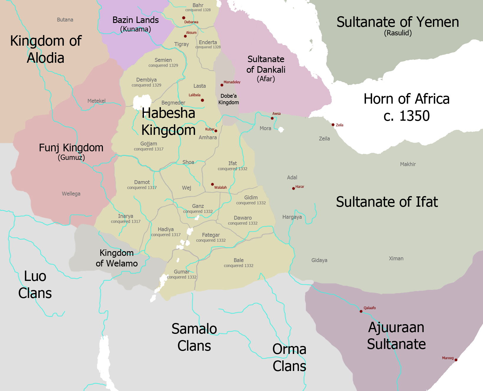
User:Ingoman. As far as I can tell, the "Samalo" clans never existed, so their inclusion is probably in reference to "Samalee," the mythical progenitor of all Somali people. This is an attempt to claim the Rendile tribe of north-central kenya as Somali which, although they share related languages, is not culturally, religiously, genetically, or in any other way proven. The Ethiopian Empire, Solomonic Ethiopia, Abyssinia, or Medieval Ethiopia are all widely accepted names in Ethiopian studies and historiography by the academic community. "Habesha kingdom" has never been used, even to refer to predecessor states such as Axum or Zagwe, and is likely a purposeful choice by the maker of this map to disassociate modern-day Ethiopia from it's previous governments or the region from the name "Ethiopia" itself. Likewise, the idea that the Ifat or successor states such as the Adal sultanate ever ruled the eastern tip of the Horn of Africa is completely false. Ifat was ruled by a Sultan in Zeila and was centered in that historic port city, with lang further inland stretching to the former central regions of the Shewa Sultanate, which they conquered, such as the Harar plateau. The Funj Sultanate also did not exist until centuries after this map is supposed to be set, and Alodia is often depicted controlling west of the Sudanese border. Along with that, neither did any sort of Afar state such as the "Danakil Sultanate," with the region historically being under the control of Ethiopian Emperors such as Baede Maryam. Likewise, the Beja kingdom of Bazin was not in existence until the 9th century, and before that the Bazin people were mentioned as being under Axumite rule in the Ezana Stone. The Beja Belew kingdoms were all destroyed at one point or another in the late medieval period, with the southernmost of those ruling central Eritrea being conquered by the Emperor Amde Tsion during the time of this map. The only accurate states are the Ajuran Sultanate and Rasulid Yemen, although I wouldn't doubt they have numerous inaccuracies as well. These maps were known to be false and not based on Scholarly work as far back as 2017 (See:
en:Talk:Oromo people/Archive 2).
Converted to regular DR to allow for discussion. -- | |||
| |||
Summary
| Description | |
| Date | |
| Source | Own work |
| Author | Ingoman |
Licensing
I, the copyright holder of this work, hereby publish it under the following license:
This file is licensed under the
Creative Commons
Attribution-Share Alike 3.0 Unported license.
- You are free:
- to share – to copy, distribute and transmit the work
- to remix – to adapt the work
- Under the following conditions:
- attribution – You must give appropriate credit, provide a link to the license, and indicate if changes were made. You may do so in any reasonable manner, but not in any way that suggests the licensor endorses you or your use.
- share alike – If you remix, transform, or build upon the material, you must distribute your contributions under the same or compatible license as the original.
File history
Click on a date/time to view the file as it appeared at that time.
| Date/Time | Thumbnail | Dimensions | User | Comment | |
|---|---|---|---|---|---|
| current | 21:17, 29 November 2013 |
| 1,638 × 1,328 (309 KB) | Ingoman | more corrections |
| 21:15, 29 November 2013 |
 | 1,638 × 1,328 (308 KB) | Ingoman | corrections | |
| 19:58, 28 November 2013 |
 | 1,638 × 1,328 (306 KB) | Ingoman | Ajuran expansion too early, plus too early for Kaffa and Dawro as independent entities, Welamo is the rump Damot state. | |
| 22:32, 27 November 2013 |
 | 1,638 × 1,328 (302 KB) | Ingoman | Darker map | |
| 22:25, 27 November 2013 |
 | 1,638 × 1,328 (300 KB) | Ingoman | User created page with UploadWizard |
File usage
The following pages on the English Wikipedia use this file (pages on other projects are not listed):
Metadata
Size of this preview:
740 × 600 pixels. Other resolutions:
296 × 240 pixels |
592 × 480 pixels |
947 × 768 pixels |
1,263 × 1,024 pixels |
1,638 × 1,328 pixels.
Original file (1,638 × 1,328 pixels, file size: 309 KB, MIME type: image/png)
| This is a file from the
Wikimedia Commons. Information from its
description page there is shown below. Commons is a freely licensed media file repository. You can help. |
This media file has been nominated for deletion since 4 April 2024. To discuss it, please visit
the nomination page.
Do not remove this tag until the deletion nomination is closed. Reason for the nomination: This file was initially tagged by
MotorolaBoy as Speedy (speedydelete) and the most recent rationale was: This map presents itself as historical but at best it's conjectural and should maybe be renamed alt history if it cannot be deleted, much like the other maps by
User:Ingoman. As far as I can tell, the "Samalo" clans never existed, so their inclusion is probably in reference to "Samalee," the mythical progenitor of all Somali people. This is an attempt to claim the Rendile tribe of north-central kenya as Somali which, although they share related languages, is not culturally, religiously, genetically, or in any other way proven. The Ethiopian Empire, Solomonic Ethiopia, Abyssinia, or Medieval Ethiopia are all widely accepted names in Ethiopian studies and historiography by the academic community. "Habesha kingdom" has never been used, even to refer to predecessor states such as Axum or Zagwe, and is likely a purposeful choice by the maker of this map to disassociate modern-day Ethiopia from it's previous governments or the region from the name "Ethiopia" itself. Likewise, the idea that the Ifat or successor states such as the Adal sultanate ever ruled the eastern tip of the Horn of Africa is completely false. Ifat was ruled by a Sultan in Zeila and was centered in that historic port city, with lang further inland stretching to the former central regions of the Shewa Sultanate, which they conquered, such as the Harar plateau. The Funj Sultanate also did not exist until centuries after this map is supposed to be set, and Alodia is often depicted controlling west of the Sudanese border. Along with that, neither did any sort of Afar state such as the "Danakil Sultanate," with the region historically being under the control of Ethiopian Emperors such as Baede Maryam. Likewise, the Beja kingdom of Bazin was not in existence until the 9th century, and before that the Bazin people were mentioned as being under Axumite rule in the Ezana Stone. The Beja Belew kingdoms were all destroyed at one point or another in the late medieval period, with the southernmost of those ruling central Eritrea being conquered by the Emperor Amde Tsion during the time of this map. The only accurate states are the Ajuran Sultanate and Rasulid Yemen, although I wouldn't doubt they have numerous inaccuracies as well. These maps were known to be false and not based on Scholarly work as far back as 2017 (See:
en:Talk:Oromo people/Archive 2).
Converted to regular DR to allow for discussion. -- | |||
| |||
Summary
| Description | |
| Date | |
| Source | Own work |
| Author | Ingoman |
Licensing
I, the copyright holder of this work, hereby publish it under the following license:
This file is licensed under the
Creative Commons
Attribution-Share Alike 3.0 Unported license.
- You are free:
- to share – to copy, distribute and transmit the work
- to remix – to adapt the work
- Under the following conditions:
- attribution – You must give appropriate credit, provide a link to the license, and indicate if changes were made. You may do so in any reasonable manner, but not in any way that suggests the licensor endorses you or your use.
- share alike – If you remix, transform, or build upon the material, you must distribute your contributions under the same or compatible license as the original.
File history
Click on a date/time to view the file as it appeared at that time.
| Date/Time | Thumbnail | Dimensions | User | Comment | |
|---|---|---|---|---|---|
| current | 21:17, 29 November 2013 |
| 1,638 × 1,328 (309 KB) | Ingoman | more corrections |
| 21:15, 29 November 2013 |
| 1,638 × 1,328 (308 KB) | Ingoman | corrections | |
| 19:58, 28 November 2013 |
| 1,638 × 1,328 (306 KB) | Ingoman | Ajuran expansion too early, plus too early for Kaffa and Dawro as independent entities, Welamo is the rump Damot state. | |
| 22:32, 27 November 2013 |
| 1,638 × 1,328 (302 KB) | Ingoman | Darker map | |
| 22:25, 27 November 2013 |
| 1,638 × 1,328 (300 KB) | Ingoman | User created page with UploadWizard |
File usage
The following pages on the English Wikipedia use this file (pages on other projects are not listed):