Photos • Location


Size of this PNG preview of this SVG file:
607 × 599 pixels. Other resolutions:
243 × 240 pixels |
486 × 480 pixels |
778 × 768 pixels |
1,037 × 1,024 pixels |
2,074 × 2,048 pixels |
1,018 × 1,005 pixels.
Original file (SVG file, nominally 1,018 × 1,005 pixels, file size: 1.32 MB)
| This is a file from the
Wikimedia Commons. Information from its
description page there is shown below. Commons is a freely licensed media file repository. You can help. |
Summary
| Description |
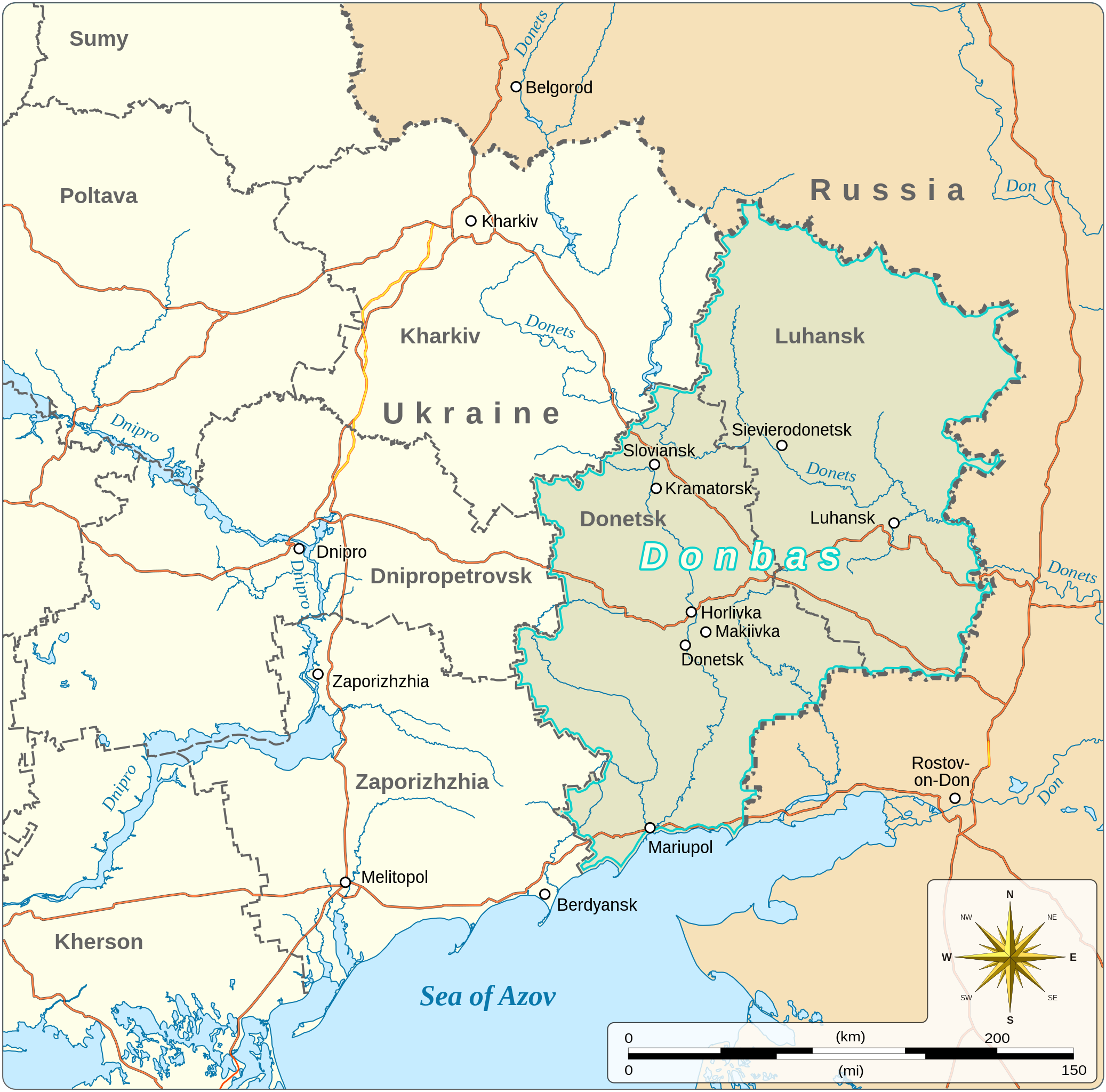
English: Map of the Donbas region of Ukraine
|
|||||||||||||||||||||||||||||||||||||
| Date | ||||||||||||||||||||||||||||||||||||||
| Source |
Own work based on:
|
|||||||||||||||||||||||||||||||||||||
| Author | Goran_tek-en | |||||||||||||||||||||||||||||||||||||
| Permission ( Reusing this file) |
This file is licensed under the
Creative Commons
Attribution-Share Alike 4.0 International license. Attribution: Goran_tek-en
|
|||||||||||||||||||||||||||||||||||||
| Other versions |
|
|||||||||||||||||||||||||||||||||||||
| SVG development | This
vector image was created with
Inkscape. |
|||||||||||||||||||||||||||||||||||||


.svg)

| Object location |
| View this and other nearby images on: OpenStreetMap |
|
|---|


File history
Click on a date/time to view the file as it appeared at that time.
| Date/Time | Thumbnail | Dimensions | User | Comment | |
|---|---|---|---|---|---|
| current | 12:41, 6 February 2023 |
| 1,018 × 1,005 (1.32 MB) | Illchy | File uploaded using svgtranslate tool (https://svgtranslate.toolforge.org/). Added translation for id. |
| 17:08, 11 October 2022 |
 | 1,018 × 1,005 (1.32 MB) | Batouki | File uploaded using svgtranslate tool (https://svgtranslate.toolforge.org/). Added translation for fr. | |
| 19:03, 13 March 2022 |
 | 1,018 × 1,005 (1.29 MB) | Goran tek-en | {{Information |description ={{en|Map of the Donbas region of Ukraine}} {{Institution |wikidata=Q16335075}} {{Institution |wikidata=Q605714}} {{Institution |wikidata=Q212}} {{Institution |wikidata=Q159}} |date =2022-03-13 |source ={{Own based|Donbas (2015–2022).svg|b1=Goran tek-en}} <br> Information from: *Requested by and knowledge from {{U|RGloucester}} |author = Goran_tek-en |permission ={{Cc-by-sa-4.0 |1= Goran_tek-en}} |other... |
File usage
The following pages on the English Wikipedia use this file (pages on other projects are not listed):
Global file usage
The following other wikis use this file:
- Usage on bg.wikipedia.org
- Usage on br.wikipedia.org
- Usage on fr.wikipedia.org
- Usage on gv.wikipedia.org
- Usage on is.wikipedia.org
- Usage on lo.wikipedia.org
- Usage on mg.wikipedia.org
- Usage on nl.wikipedia.org
- Usage on pt.wikipedia.org
- Usage on sl.wikipedia.org
- Usage on uz.wikipedia.org
Metadata
Size of this PNG preview of this SVG file:
607 × 599 pixels. Other resolutions:
243 × 240 pixels |
486 × 480 pixels |
778 × 768 pixels |
1,037 × 1,024 pixels |
2,074 × 2,048 pixels |
1,018 × 1,005 pixels.
Original file (SVG file, nominally 1,018 × 1,005 pixels, file size: 1.32 MB)
| This is a file from the
Wikimedia Commons. Information from its
description page there is shown below. Commons is a freely licensed media file repository. You can help. |
Summary
| Description |
English: Map of the Donbas region of Ukraine
|
|||||||||||||||||||||||||||||||||||||
| Date | ||||||||||||||||||||||||||||||||||||||
| Source |
Own work based on:
|
|||||||||||||||||||||||||||||||||||||
| Author | Goran_tek-en | |||||||||||||||||||||||||||||||||||||
| Permission ( Reusing this file) |
This file is licensed under the
Creative Commons
Attribution-Share Alike 4.0 International license. Attribution: Goran_tek-en
|
|||||||||||||||||||||||||||||||||||||
| Other versions |
|
|||||||||||||||||||||||||||||||||||||
| SVG development | This
vector image was created with
Inkscape. |
|||||||||||||||||||||||||||||||||||||
| Object location |
| View this and other nearby images on: OpenStreetMap |
|
|---|
File history
Click on a date/time to view the file as it appeared at that time.
| Date/Time | Thumbnail | Dimensions | User | Comment | |
|---|---|---|---|---|---|
| current | 12:41, 6 February 2023 |
| 1,018 × 1,005 (1.32 MB) | Illchy | File uploaded using svgtranslate tool (https://svgtranslate.toolforge.org/). Added translation for id. |
| 17:08, 11 October 2022 |
| 1,018 × 1,005 (1.32 MB) | Batouki | File uploaded using svgtranslate tool (https://svgtranslate.toolforge.org/). Added translation for fr. | |
| 19:03, 13 March 2022 |
| 1,018 × 1,005 (1.29 MB) | Goran tek-en | {{Information |description ={{en|Map of the Donbas region of Ukraine}} {{Institution |wikidata=Q16335075}} {{Institution |wikidata=Q605714}} {{Institution |wikidata=Q212}} {{Institution |wikidata=Q159}} |date =2022-03-13 |source ={{Own based|Donbas (2015–2022).svg|b1=Goran tek-en}} <br> Information from: *Requested by and knowledge from {{U|RGloucester}} |author = Goran_tek-en |permission ={{Cc-by-sa-4.0 |1= Goran_tek-en}} |other... |
File usage
The following pages on the English Wikipedia use this file (pages on other projects are not listed):
Global file usage
The following other wikis use this file:
- Usage on bg.wikipedia.org
- Usage on br.wikipedia.org
- Usage on fr.wikipedia.org
- Usage on gv.wikipedia.org
- Usage on is.wikipedia.org
- Usage on lo.wikipedia.org
- Usage on mg.wikipedia.org
- Usage on nl.wikipedia.org
- Usage on pt.wikipedia.org
- Usage on sl.wikipedia.org
- Usage on uz.wikipedia.org