
Original file (SVG file, nominally 512 × 841 pixels, file size: 2.59 MB)
| This is a file from the
Wikimedia Commons. Information from its
description page there is shown below. Commons is a freely licensed media file repository. You can help. |
Summary
| Description |
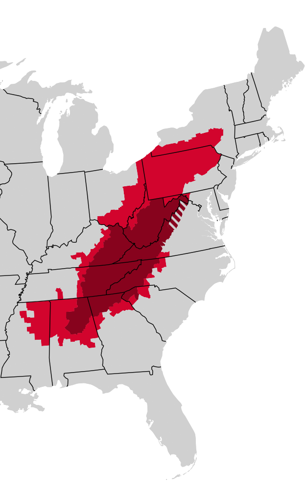
English: Map of Appalachia, red covers counties in the Appalachian Regional Comission, dark red covers "Consensus Appalachia" by John Alexander Williams, striped counties are not ARC counties. |
| Date | |
| Source | Own work, Appalachia Regional Commission, John A. Williams |
| Author | Sprucecopse |
Sources:
ARC counties:
https://www.arc.gov/about-the-appalachian-region/
"Consensus Appalachia" by John Alexander Williams:
https://geography.vt.edu/content/dam/geography_vt_edu/scales-files/Scales%20Satterwhite%20August%20Mapping%20Appalachia.pdf
Licensing
| This file is made available under the Creative Commons CC0 1.0 Universal Public Domain Dedication. | |
| The person who associated a work with this deed has dedicated the work to the
public domain by waiving all of their rights to the work worldwide under copyright law, including all related and neighboring rights, to the extent allowed by law. You can copy, modify, distribute and perform the work, even for commercial purposes, all without asking permission.
|
File history
Click on a date/time to view the file as it appeared at that time.
| Date/Time | Thumbnail | Dimensions | User | Comment | |
|---|---|---|---|---|---|
| current | 16:12, 19 February 2024 |
| 512 × 841 (2.59 MB) | Sprucecopse | Uploaded own work with UploadWizard |
File usage
Metadata
Original file (SVG file, nominally 512 × 841 pixels, file size: 2.59 MB)
| This is a file from the
Wikimedia Commons. Information from its
description page there is shown below. Commons is a freely licensed media file repository. You can help. |
Summary
| Description |
English: Map of Appalachia, red covers counties in the Appalachian Regional Comission, dark red covers "Consensus Appalachia" by John Alexander Williams, striped counties are not ARC counties. |
| Date | |
| Source | Own work, Appalachia Regional Commission, John A. Williams |
| Author | Sprucecopse |
Sources:
ARC counties:
https://www.arc.gov/about-the-appalachian-region/
"Consensus Appalachia" by John Alexander Williams:
https://geography.vt.edu/content/dam/geography_vt_edu/scales-files/Scales%20Satterwhite%20August%20Mapping%20Appalachia.pdf
Licensing
| This file is made available under the Creative Commons CC0 1.0 Universal Public Domain Dedication. | |
| The person who associated a work with this deed has dedicated the work to the
public domain by waiving all of their rights to the work worldwide under copyright law, including all related and neighboring rights, to the extent allowed by law. You can copy, modify, distribute and perform the work, even for commercial purposes, all without asking permission.
|
File history
Click on a date/time to view the file as it appeared at that time.
| Date/Time | Thumbnail | Dimensions | User | Comment | |
|---|---|---|---|---|---|
| current | 16:12, 19 February 2024 |
| 512 × 841 (2.59 MB) | Sprucecopse | Uploaded own work with UploadWizard |