No higher resolution available.
Map-Gaua-Vanuatu.png (727 × 544 pixels, file size: 37 KB, MIME type: image/png)
| This is a file from the
Wikimedia Commons. Information from its
description page there is shown below. Commons is a freely licensed media file repository. You can help. |
| Description |
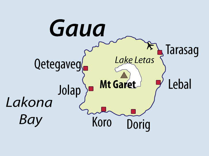
English: I have drawn this map of the island of
en:Gaua (Vanuatu) based on several other maps showing sufficient precision. I paid special attention to the transcription of place names, based on personal fieldwork on Gaua, and professional knowledge of the local languages. |
| Date | |
| Source | Own work |
| Author | Alexandre François |
| Permission ( Reusing this file) |
This file is licensed under the
Creative Commons
Attribution 3.0 Unported license. Attribution: Alexandre François
|
File history
Click on a date/time to view the file as it appeared at that time.
| Date/Time | Thumbnail | Dimensions | User | Comment | |
|---|---|---|---|---|---|
| current | 08:33, 23 November 2010 |
| 727 × 544 (37 KB) | Womtelo | {{Information |Description={{en|1=I have drawn this map of the Torres Islands (Vanuatu) based on several other maps showing sufficient precision. I paid special attention to the transcription of place names, based on personal fieldwork on Gaua, and profes |
File usage
The following pages on the English Wikipedia use this file (pages on other projects are not listed):
Global file usage
The following other wikis use this file:
- Usage on ast.wikipedia.org
- Usage on bg.wikipedia.org
- Usage on de.wikipedia.org
- Usage on diq.wikipedia.org
- Usage on eo.wikipedia.org
- Usage on es.wikipedia.org
- Usage on fa.wikipedia.org
- Usage on fr.wikipedia.org
- Usage on gl.wikipedia.org
- Usage on id.wikipedia.org
- Usage on ka.wikipedia.org
- Usage on mrj.wikipedia.org
- Usage on pl.wikipedia.org
- Usage on pt.wikipedia.org
- Usage on ru.wikipedia.org
- Usage on sw.wikipedia.org
- Usage on uk.wikipedia.org
- Usage on vi.wikipedia.org
- Usage on www.wikidata.org
- Usage on zh.wikipedia.org
No higher resolution available.
Map-Gaua-Vanuatu.png (727 × 544 pixels, file size: 37 KB, MIME type: image/png)
| This is a file from the
Wikimedia Commons. Information from its
description page there is shown below. Commons is a freely licensed media file repository. You can help. |
| Description |
English: I have drawn this map of the island of
en:Gaua (Vanuatu) based on several other maps showing sufficient precision. I paid special attention to the transcription of place names, based on personal fieldwork on Gaua, and professional knowledge of the local languages. |
| Date | |
| Source | Own work |
| Author | Alexandre François |
| Permission ( Reusing this file) |
This file is licensed under the
Creative Commons
Attribution 3.0 Unported license. Attribution: Alexandre François
|
File history
Click on a date/time to view the file as it appeared at that time.
| Date/Time | Thumbnail | Dimensions | User | Comment | |
|---|---|---|---|---|---|
| current | 08:33, 23 November 2010 |
| 727 × 544 (37 KB) | Womtelo | {{Information |Description={{en|1=I have drawn this map of the Torres Islands (Vanuatu) based on several other maps showing sufficient precision. I paid special attention to the transcription of place names, based on personal fieldwork on Gaua, and profes |
File usage
The following pages on the English Wikipedia use this file (pages on other projects are not listed):
Global file usage
The following other wikis use this file:
- Usage on ast.wikipedia.org
- Usage on bg.wikipedia.org
- Usage on de.wikipedia.org
- Usage on diq.wikipedia.org
- Usage on eo.wikipedia.org
- Usage on es.wikipedia.org
- Usage on fa.wikipedia.org
- Usage on fr.wikipedia.org
- Usage on gl.wikipedia.org
- Usage on id.wikipedia.org
- Usage on ka.wikipedia.org
- Usage on mrj.wikipedia.org
- Usage on pl.wikipedia.org
- Usage on pt.wikipedia.org
- Usage on ru.wikipedia.org
- Usage on sw.wikipedia.org
- Usage on uk.wikipedia.org
- Usage on vi.wikipedia.org
- Usage on www.wikidata.org
- Usage on zh.wikipedia.org