Photos • Location


Size of this preview:
753 × 600 pixels. Other resolutions:
301 × 240 pixels |
603 × 480 pixels |
964 × 768 pixels |
1,280 × 1,020 pixels |
2,344 × 1,867 pixels.
Original file (2,344 × 1,867 pixels, file size: 937 KB, MIME type: image/jpeg)
| This is a file from the
Wikimedia Commons. Information from its
description page there is shown below. Commons is a freely licensed media file repository. You can help. |
Summary
| Description |
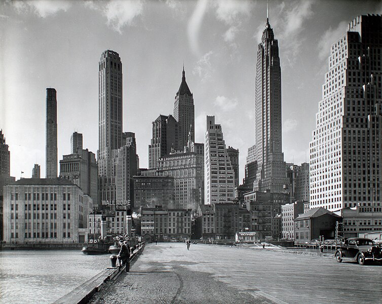
English: Manhattan Skyline: I. South Street and Jones Lane from East River Pier 11, Manhattan. 120 Wall Street far right; American International bldg right, 40 Wall St pointy top in center. Apparent advertisings: Wallrope, McMillan Shackle Blocks, Downtown Skyport. |
||||||||||||||||||||||||||
| Date | |||||||||||||||||||||||||||
| Source | https://www.flickr.com/photos/nypl/3109783051/ | ||||||||||||||||||||||||||
| Author |
|
||||||||||||||||||||||||||
| Other versions | File:Manhattan Skyline- I. South Street and Jones Lane, Manhattan (NYPL b13668355-482569).tiff | ||||||||||||||||||||||||||

| Camera location | | View this and other nearby images on: OpenStreetMap |
|
|---|
Licensing
This image is a work of a
Works Progress Administration employee, taken or made as part of that person's official duties. As a
work of the
U.S. federal government, the image is in the
public domain (17 U.S.C. §§ 101 and 105).
|
 |
| Annotations | This image is annotated: View the annotations at Commons |
File history
Click on a date/time to view the file as it appeared at that time.
| Date/Time | Thumbnail | Dimensions | User | Comment | |
|---|---|---|---|---|---|
| current | 03:25, 12 June 2022 |
| 2,344 × 1,867 (937 KB) | Vzeebjtf | Cropped 24 % horizontally, 20 % vertically using CropTool with lossless mode. |
| 17:17, 1 April 2020 |
 | 3,072 × 2,320 (1.51 MB) | FARHAAD 1992 | higher resolution | |
| 21:53, 23 October 2010 |
 | 760 × 611 (86 KB) | Sonty567 | {{Information |Description={{en|1=Manhattan Skyline: I. South Street and Jones Lane, Manhattan}} |Source=http://www.flickr.com/photos/nypl/3109783051/ |Author=Berenice Abbott |Date=March 26, 1936 |Permission={{PD-USGov-WPA}} |other_versions= }} [[Categor |
File usage
The following pages on the English Wikipedia use this file (pages on other projects are not listed):
Global file usage
The following other wikis use this file:
- Usage on fr.wikipedia.org
- Usage on it.wikibooks.org
- Usage on nl.wikipedia.org
- Usage on sv.wikipedia.org
Size of this preview:
753 × 600 pixels. Other resolutions:
301 × 240 pixels |
603 × 480 pixels |
964 × 768 pixels |
1,280 × 1,020 pixels |
2,344 × 1,867 pixels.
Original file (2,344 × 1,867 pixels, file size: 937 KB, MIME type: image/jpeg)
| This is a file from the
Wikimedia Commons. Information from its
description page there is shown below. Commons is a freely licensed media file repository. You can help. |
Summary
| Description |
English: Manhattan Skyline: I. South Street and Jones Lane from East River Pier 11, Manhattan. 120 Wall Street far right; American International bldg right, 40 Wall St pointy top in center. Apparent advertisings: Wallrope, McMillan Shackle Blocks, Downtown Skyport. |
||||||||||||||||||||||||||
| Date | |||||||||||||||||||||||||||
| Source | https://www.flickr.com/photos/nypl/3109783051/ | ||||||||||||||||||||||||||
| Author |
|
||||||||||||||||||||||||||
| Other versions | File:Manhattan Skyline- I. South Street and Jones Lane, Manhattan (NYPL b13668355-482569).tiff | ||||||||||||||||||||||||||
| Camera location | | View this and other nearby images on: OpenStreetMap |
|
|---|
Licensing
This image is a work of a
Works Progress Administration employee, taken or made as part of that person's official duties. As a
work of the
U.S. federal government, the image is in the
public domain (17 U.S.C. §§ 101 and 105).
|
|
| Annotations | This image is annotated: View the annotations at Commons |
File history
Click on a date/time to view the file as it appeared at that time.
| Date/Time | Thumbnail | Dimensions | User | Comment | |
|---|---|---|---|---|---|
| current | 03:25, 12 June 2022 |
| 2,344 × 1,867 (937 KB) | Vzeebjtf | Cropped 24 % horizontally, 20 % vertically using CropTool with lossless mode. |
| 17:17, 1 April 2020 |
| 3,072 × 2,320 (1.51 MB) | FARHAAD 1992 | higher resolution | |
| 21:53, 23 October 2010 |
| 760 × 611 (86 KB) | Sonty567 | {{Information |Description={{en|1=Manhattan Skyline: I. South Street and Jones Lane, Manhattan}} |Source=http://www.flickr.com/photos/nypl/3109783051/ |Author=Berenice Abbott |Date=March 26, 1936 |Permission={{PD-USGov-WPA}} |other_versions= }} [[Categor |
File usage
The following pages on the English Wikipedia use this file (pages on other projects are not listed):
Global file usage
The following other wikis use this file:
- Usage on fr.wikipedia.org
- Usage on it.wikibooks.org
- Usage on nl.wikipedia.org
- Usage on sv.wikipedia.org