Size of this preview:
800 × 530 pixels. Other resolutions:
320 × 212 pixels |
640 × 424 pixels |
1,024 × 678 pixels |
1,280 × 848 pixels |
3,032 × 2,008 pixels.
Original file (3,032 × 2,008 pixels, file size: 1.2 MB, MIME type: image/jpeg)
| This is a file from the
Wikimedia Commons. Information from its
description page there is shown below. Commons is a freely licensed media file repository. You can help. |
.jpg)
Summary
| Description |
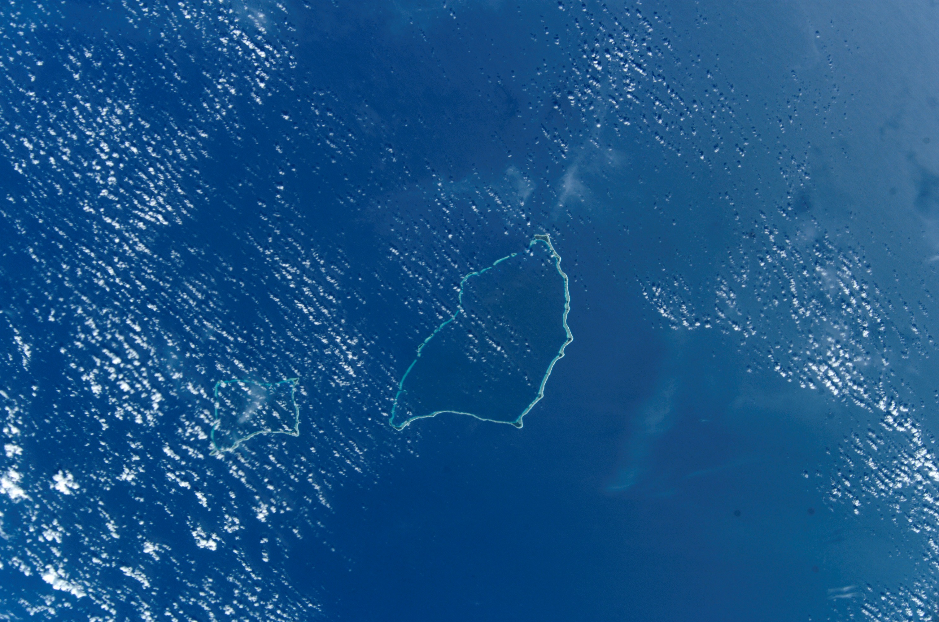
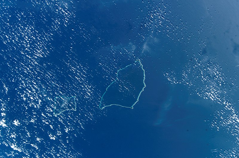
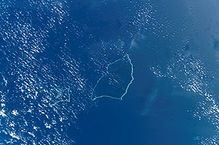
Deutsch: NASA-Astronautenbild der Atolle Maloelap und Aur (Ralik-Kette, Marshallinseln) im Pazifik
English: NASA Astronaut Image of Maloelap & Aur Atoll (Ralik Chain, Marshall Islands) in the Pacific Ocean
Español: Atolón Ailinginae
Русский: Космический снимок НАСА атолла Аилингинаэ (цепь Ралик, Маршалловы острова) в Тихом океане |
| Date | UTC |
| Source | http://eol.jsc.nasa.gov/scripts/sseop/photo.pl?mission=ISS004&roll=E&frame=10164 |
| Author | NASA/JSC |
| Permission ( Reusing this file) |
Conditions of Use of Astronaut Photographs |
This image or video was catalogued by Johnson Space Center of the United States
National Aeronautics and Space Administration (NASA) under Photo ID:
ISS004-E-10164. This tag does not indicate the copyright status of the attached work. A normal copyright tag is still required. See Commons:Licensing. Other languages:
|
Licensing
This file is in the
public domain in the United States because it was created by the Image Science & Analysis Laboratory, of the
NASA Johnson Space Center. NASA copyright policy states that "NASA material is not protected by copyright unless noted". (
NASA media use guidelines or
Conditions of Use of Astronaut Photographs).
Photo source:
ISS004-E-10164.
|
File history
Click on a date/time to view the file as it appeared at that time.
| Date/Time | Thumbnail | Dimensions | User | Comment | |
|---|---|---|---|---|---|
| current | 18:11, 27 October 2014 |
| 3,032 × 2,008 (1.2 MB) | Ras67 | high res |
| 12:25, 30 September 2005 |
 | 639 × 435 (93 KB) | Los688 | Maloelap Atoll.Marshal islands. From http://eol.jsc.nasa.gov/scripts/sseop/photo.pl?mission=ISS004&roll=E&frame=10164&QueryResultsFile=11280825067482.tsv ISS004 mission. Date: 2002:04:19 GMT Time: 22:31:34 Nadir Point Latitude: N13.9, Longitude: E171.1 Ph |
File usage
The following pages on the English Wikipedia use this file (pages on other projects are not listed):
Global file usage
The following other wikis use this file:
- Usage on ast.wikipedia.org
- Usage on ca.wikipedia.org
- Usage on ceb.wikipedia.org
- Usage on de.wikipedia.org
- Usage on en.wikivoyage.org
- Usage on es.wikipedia.org
- Usage on fa.wikipedia.org
- Usage on fi.wikipedia.org
- Usage on fr.wikipedia.org
- Usage on gl.wikipedia.org
- Usage on hu.wikipedia.org
- Usage on id.wikipedia.org
- Usage on it.wikipedia.org
- Usage on ja.wikipedia.org
- Usage on ko.wikipedia.org
- Usage on lt.wikipedia.org
- Usage on lv.wikipedia.org
- Usage on mk.wikipedia.org
- Usage on mt.wikipedia.org
- Usage on nn.wikipedia.org
- Usage on pl.wikipedia.org
- Usage on ru.wikipedia.org
- Usage on sv.wikipedia.org
- Usage on uk.wikipedia.org
- Usage on ur.wikipedia.org
- Usage on www.wikidata.org
View more global usage of this file.
.jpg)
.jpg)
Size of this preview:
800 × 530 pixels. Other resolutions:
320 × 212 pixels |
640 × 424 pixels |
1,024 × 678 pixels |
1,280 × 848 pixels |
3,032 × 2,008 pixels.
Original file (3,032 × 2,008 pixels, file size: 1.2 MB, MIME type: image/jpeg)
| This is a file from the
Wikimedia Commons. Information from its
description page there is shown below. Commons is a freely licensed media file repository. You can help. |
Summary
| Description |
Deutsch: NASA-Astronautenbild der Atolle Maloelap und Aur (Ralik-Kette, Marshallinseln) im Pazifik
English: NASA Astronaut Image of Maloelap & Aur Atoll (Ralik Chain, Marshall Islands) in the Pacific Ocean
Español: Atolón Ailinginae
Русский: Космический снимок НАСА атолла Аилингинаэ (цепь Ралик, Маршалловы острова) в Тихом океане |
| Date | UTC |
| Source | http://eol.jsc.nasa.gov/scripts/sseop/photo.pl?mission=ISS004&roll=E&frame=10164 |
| Author | NASA/JSC |
| Permission ( Reusing this file) |
Conditions of Use of Astronaut Photographs |
This image or video was catalogued by Johnson Space Center of the United States
National Aeronautics and Space Administration (NASA) under Photo ID:
ISS004-E-10164. This tag does not indicate the copyright status of the attached work. A normal copyright tag is still required. See Commons:Licensing. Other languages:
|
Licensing
This file is in the
public domain in the United States because it was created by the Image Science & Analysis Laboratory, of the
NASA Johnson Space Center. NASA copyright policy states that "NASA material is not protected by copyright unless noted". (
NASA media use guidelines or
Conditions of Use of Astronaut Photographs).
Photo source:
ISS004-E-10164.
|
File history
Click on a date/time to view the file as it appeared at that time.
| Date/Time | Thumbnail | Dimensions | User | Comment | |
|---|---|---|---|---|---|
| current | 18:11, 27 October 2014 |
| 3,032 × 2,008 (1.2 MB) | Ras67 | high res |
| 12:25, 30 September 2005 |
| 639 × 435 (93 KB) | Los688 | Maloelap Atoll.Marshal islands. From http://eol.jsc.nasa.gov/scripts/sseop/photo.pl?mission=ISS004&roll=E&frame=10164&QueryResultsFile=11280825067482.tsv ISS004 mission. Date: 2002:04:19 GMT Time: 22:31:34 Nadir Point Latitude: N13.9, Longitude: E171.1 Ph |
File usage
The following pages on the English Wikipedia use this file (pages on other projects are not listed):
Global file usage
The following other wikis use this file:
- Usage on ast.wikipedia.org
- Usage on ca.wikipedia.org
- Usage on ceb.wikipedia.org
- Usage on de.wikipedia.org
- Usage on en.wikivoyage.org
- Usage on es.wikipedia.org
- Usage on fa.wikipedia.org
- Usage on fi.wikipedia.org
- Usage on fr.wikipedia.org
- Usage on gl.wikipedia.org
- Usage on hu.wikipedia.org
- Usage on id.wikipedia.org
- Usage on it.wikipedia.org
- Usage on ja.wikipedia.org
- Usage on ko.wikipedia.org
- Usage on lt.wikipedia.org
- Usage on lv.wikipedia.org
- Usage on mk.wikipedia.org
- Usage on mt.wikipedia.org
- Usage on nn.wikipedia.org
- Usage on pl.wikipedia.org
- Usage on ru.wikipedia.org
- Usage on sv.wikipedia.org
- Usage on uk.wikipedia.org
- Usage on ur.wikipedia.org
- Usage on www.wikidata.org
View more global usage of this file.