
Original file (1,000 × 750 pixels, file size: 207 KB, MIME type: image/jpeg)
| This is a file from the
Wikimedia Commons. Information from its
description page there is shown below. Commons is a freely licensed media file repository. You can help. |
Summary
|
|
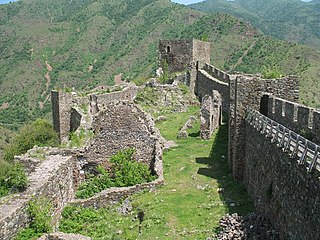
This is a photo of
Cultural Heritage site of Serbia number
СК 168
|
Maglic fortress near Kraljevo.
View from the south wall.
Licensing
| This work has been released into the
public domain by its author,
CrniBombarder!!!. This applies worldwide. In some countries this may not be legally possible; if so: |
| Object location |
| View this and other nearby images on: OpenStreetMap |
|
|---|
File history
Click on a date/time to view the file as it appeared at that time.
| Date/Time | Thumbnail | Dimensions | User | Comment | |
|---|---|---|---|---|---|
| current | 23:45, 12 September 2006 |
| 1,000 × 750 (207 KB) | CrniBombarder!!! | |
| 02:03, 17 February 2006 |
 | 977 × 673 (85 KB) | CrniBombarder!!! | Maglic fortress near Kraljevo. View from the south wall. |
File usage
Global file usage
The following other wikis use this file:
- Usage on be.wikipedia.org
- Usage on bg.wikipedia.org
- Usage on de.wikipedia.org
- Usage on el.wikipedia.org
- Usage on fr.wikipedia.org
- Usage on hu.wikipedia.org
- Usage on hy.wikipedia.org
- Usage on ka.wikipedia.org
- Usage on mk.wikipedia.org
- Usage on ro.wikipedia.org
- Usage on ru.wikipedia.org
- Usage on ru.wikivoyage.org
- Usage on sh.wikipedia.org
- Usage on sl.wikipedia.org
- Usage on sr.wikipedia.org
- Usage on ty.wikipedia.org
- Usage on www.wikidata.org
Metadata
Original file (1,000 × 750 pixels, file size: 207 KB, MIME type: image/jpeg)
| This is a file from the
Wikimedia Commons. Information from its
description page there is shown below. Commons is a freely licensed media file repository. You can help. |
Summary
|
|
This is a photo of
Cultural Heritage site of Serbia number
СК 168
|
Maglic fortress near Kraljevo.
View from the south wall.
Licensing
| This work has been released into the
public domain by its author,
CrniBombarder!!!. This applies worldwide. In some countries this may not be legally possible; if so: |
| Object location |
| View this and other nearby images on: OpenStreetMap |
|
|---|
File history
Click on a date/time to view the file as it appeared at that time.
| Date/Time | Thumbnail | Dimensions | User | Comment | |
|---|---|---|---|---|---|
| current | 23:45, 12 September 2006 |
| 1,000 × 750 (207 KB) | CrniBombarder!!! | |
| 02:03, 17 February 2006 |
| 977 × 673 (85 KB) | CrniBombarder!!! | Maglic fortress near Kraljevo. View from the south wall. |
File usage
Global file usage
The following other wikis use this file:
- Usage on be.wikipedia.org
- Usage on bg.wikipedia.org
- Usage on de.wikipedia.org
- Usage on el.wikipedia.org
- Usage on fr.wikipedia.org
- Usage on hu.wikipedia.org
- Usage on hy.wikipedia.org
- Usage on ka.wikipedia.org
- Usage on mk.wikipedia.org
- Usage on ro.wikipedia.org
- Usage on ru.wikipedia.org
- Usage on ru.wikivoyage.org
- Usage on sh.wikipedia.org
- Usage on sl.wikipedia.org
- Usage on sr.wikipedia.org
- Usage on ty.wikipedia.org
- Usage on www.wikidata.org