
Original file (1,846 × 1,372 pixels, file size: 1.54 MB, MIME type: image/png)
| This is a file from the
Wikimedia Commons. Information from its
description page there is shown below. Commons is a freely licensed media file repository. You can help. |
== Summary == sents i havent been creided for anything in 4 years for nothing i have done and i gave you the lilttle push this morning aka tiny boy aka dog boy aka DustinMichealCrawford--ALbright and put on there the advancment in the medical field because in got 227 trtillion in dadta on cures for every thing to add to this grid if need to
| Description |
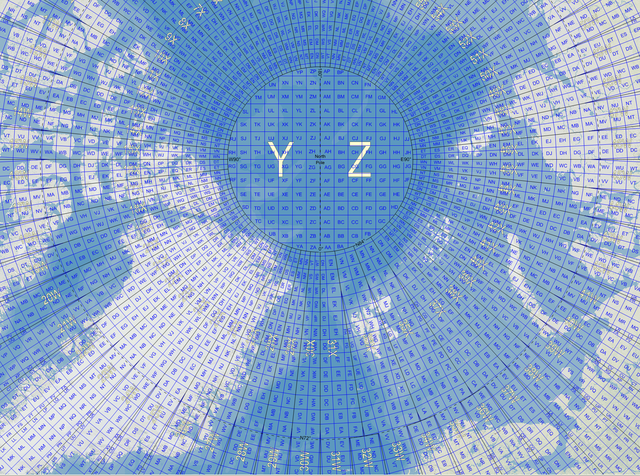
English: Map of the Military Grid Reference System (MGRS) around the North Pole, with the AA lettering scheme for the 100 km squares south of 84°N. |
| Date | |
| Source |
English: Mikael R made the MGRS grid in Carmenta Engine, with a background map from Natural Earth by Tom Patterson, US National Park Service. |
| Author | Mikael Rittri ( MikaelR) |
Licensing
- You are free:
- to share – to copy, distribute and transmit the work
- to remix – to adapt the work
- Under the following conditions:
- attribution – You must give appropriate credit, provide a link to the license, and indicate if changes were made. You may do so in any reasonable manner, but not in any way that suggests the licensor endorses you or your use.
- share alike – If you remix, transform, or build upon the material, you must distribute your contributions under the same or compatible license as the original.
File history
Click on a date/time to view the file as it appeared at that time.
| Date/Time | Thumbnail | Dimensions | User | Comment | |
|---|---|---|---|---|---|
| current | 12:03, 21 November 2007 |
| 1,846 × 1,372 (1.54 MB) | MikaelR | {{Information |Description={{en|Map of the Military Grid Reference System (MGRS) around the North Pole, with the AA lettering scheme for the 100 km squares south of 84°N.}} |Source={{en|Mikael R made the MGRS grid in SpatialAce of Carmenta, with a backgr |
File usage
Global file usage
The following other wikis use this file:
- Usage on fi.wikipedia.org
- Usage on no.wikipedia.org
- Usage on sv.wikipedia.org
- Usage on zh.wikipedia.org
Original file (1,846 × 1,372 pixels, file size: 1.54 MB, MIME type: image/png)
| This is a file from the
Wikimedia Commons. Information from its
description page there is shown below. Commons is a freely licensed media file repository. You can help. |
== Summary == sents i havent been creided for anything in 4 years for nothing i have done and i gave you the lilttle push this morning aka tiny boy aka dog boy aka DustinMichealCrawford--ALbright and put on there the advancment in the medical field because in got 227 trtillion in dadta on cures for every thing to add to this grid if need to
| Description |
English: Map of the Military Grid Reference System (MGRS) around the North Pole, with the AA lettering scheme for the 100 km squares south of 84°N. |
| Date | |
| Source |
English: Mikael R made the MGRS grid in Carmenta Engine, with a background map from Natural Earth by Tom Patterson, US National Park Service. |
| Author | Mikael Rittri ( MikaelR) |
Licensing
- You are free:
- to share – to copy, distribute and transmit the work
- to remix – to adapt the work
- Under the following conditions:
- attribution – You must give appropriate credit, provide a link to the license, and indicate if changes were made. You may do so in any reasonable manner, but not in any way that suggests the licensor endorses you or your use.
- share alike – If you remix, transform, or build upon the material, you must distribute your contributions under the same or compatible license as the original.
File history
Click on a date/time to view the file as it appeared at that time.
| Date/Time | Thumbnail | Dimensions | User | Comment | |
|---|---|---|---|---|---|
| current | 12:03, 21 November 2007 |
| 1,846 × 1,372 (1.54 MB) | MikaelR | {{Information |Description={{en|Map of the Military Grid Reference System (MGRS) around the North Pole, with the AA lettering scheme for the 100 km squares south of 84°N.}} |Source={{en|Mikael R made the MGRS grid in SpatialAce of Carmenta, with a backgr |
File usage
Global file usage
The following other wikis use this file:
- Usage on fi.wikipedia.org
- Usage on no.wikipedia.org
- Usage on sv.wikipedia.org
- Usage on zh.wikipedia.org