
Size of this PNG preview of this SVG file:
761 × 599 pixels. Other resolutions:
305 × 240 pixels |
610 × 480 pixels |
975 × 768 pixels |
1,280 × 1,008 pixels |
2,560 × 2,016 pixels |
796 × 627 pixels.
Original file (SVG file, nominally 796 × 627 pixels, file size: 1.89 MB)
| This is a file from the
Wikimedia Commons. Information from its
description page there is shown below. Commons is a freely licensed media file repository. You can help. |
Summary
| Description |
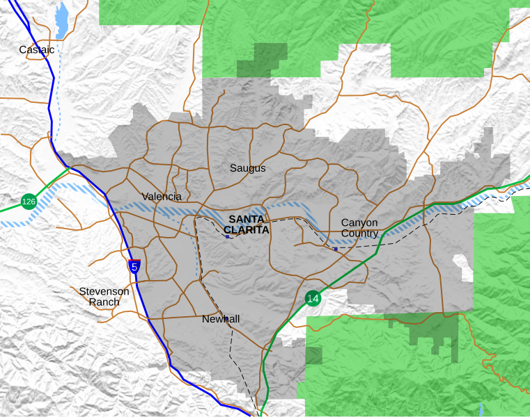
English: Location map for the Santa Clarita Valley in southern California. The scope of the map includes the entire city of Santa Clarita, as well as the nearby unincorporated communities of Stevenson Ranch and part of Castaic.
Legend: Interstate 5
California State Routes (14 and 126)
Major surface streets
Metrolink rail line
Metrolink station (blue boxes)
Santa Clarita city limit (as of 2021)
Permanent bodies of water
Intermittent bodies of water (Santa Clara River and tributaries)
Angeles National Forest |
| Date | |
| Source | Own work, with data from OpenStreetMap. Shaded relief derived from USGS. |
| Author | Crossover1370 |
Licensing
I, the copyright holder of this work, hereby publish it under the following license:
This file is licensed under the
Creative Commons
Attribution-Share Alike 4.0 International license.
- You are free:
- to share – to copy, distribute and transmit the work
- to remix – to adapt the work
- Under the following conditions:
- attribution – You must give appropriate credit, provide a link to the license, and indicate if changes were made. You may do so in any reasonable manner, but not in any way that suggests the licensor endorses you or your use.
- share alike – If you remix, transform, or build upon the material, you must distribute your contributions under the same or compatible license as the original.
File history
Click on a date/time to view the file as it appeared at that time.
| Date/Time | Thumbnail | Dimensions | User | Comment | |
|---|---|---|---|---|---|
| current | 21:05, 24 September 2021 |
| 796 × 627 (1.89 MB) | Crossover1370 | Remove the relatively minor Canyon Park Blvd and Lost Canyon Rd, and add Tourney Rd, a major street home to numerous hotels, government, and medical offices. |
| 21:47, 21 September 2021 |
 | 796 × 627 (1.89 MB) | Crossover1370 | A few minor changes involving 3-D placement of certain roads and railroads | |
| 22:56, 20 September 2021 |
 | 796 × 627 (1.89 MB) | Crossover1370 | Move the word "Santa Clarita" to top to allow it to be selected like the neighborhood names (no visible difference) | |
| 22:11, 20 September 2021 |
 | 796 × 627 (1.89 MB) | Crossover1370 | Sand Canyon Road and Newhall Ranch Road both pass above their respective freeways. Also add Metrolink stations. | |
| 01:15, 20 September 2021 |
 | 796 × 627 (1.89 MB) | Crossover1370 | Correct 3D position of streets relative to I-5, rearrange certain objects | |
| 07:01, 19 September 2021 |
 | 796 × 627 (1.89 MB) | Crossover1370 | Changed outline of Santa Clarita to shading, add Metrolink train and more streets | |
| 18:31, 26 March 2021 |
 | 797 × 628 (1,015 KB) | Crossover1370 | Remove section of Placerita Canyon Road west of Sierra Highway - not a major street. | |
| 01:23, 26 March 2021 |
 | 797 × 628 (1,016 KB) | Crossover1370 | Removed some minor streets I added in the previous revision. | |
| 07:11, 25 March 2021 |
 | 797 × 628 (1,016 KB) | Crossover1370 | Added more major streets. | |
| 05:10, 23 December 2020 |
 | 797 × 628 (1,013 KB) | Crossover1370 | Santa Clara River is still a big black blob. Hopefully this will fix it. |
File usage
The following pages on the English Wikipedia use this file (pages on other projects are not listed):
- 2019 Saugus High School shooting
- Beale's Cut Stagecoach Pass
- Canyon Country, Santa Clarita, California
- Castaic, California
- Castaic Junction, California
- Central Park (Santa Clarita)
- College of the Canyons
- Dry Canyon Reservoir
- Gibbon Conservation Center
- Golden Oak Ranch
- Lang Southern Pacific Station
- Lyons Station Stagecoach Stop
- Master's University
- McBean Regional Transit Center
- Mentryville, California
- Newhall, Santa Clarita, California
- Newhall Pass
- Newhall incident
- Peter J. Pitchess Detention Center
- Pioneer Oil Refinery
- Placerita Canyon State Park
- Rancho San Francisco
- Sand Canyon, Santa Clarita, California
- Santa Clarita, California
- Santa Clarita Woodlands Park
- Saugus, Santa Clarita, California
- Six Flags Magic Mountain
- Stevenson Ranch, California
- Valencia, California
- Valencia, Santa Clarita, California
- Valencia Country Club
- William S. Hart Regional Park
- User:Crossover1370
- Module:Location map/data/Santa Clarita
- Module:Location map/data/Santa Clarita/doc
Global file usage
The following other wikis use this file:
- Usage on fy.wikipedia.org
- Usage on si.wikipedia.org
- Usage on sv.wikipedia.org
- Usage on zh.wikipedia.org
Metadata
Size of this PNG preview of this SVG file:
761 × 599 pixels. Other resolutions:
305 × 240 pixels |
610 × 480 pixels |
975 × 768 pixels |
1,280 × 1,008 pixels |
2,560 × 2,016 pixels |
796 × 627 pixels.
Original file (SVG file, nominally 796 × 627 pixels, file size: 1.89 MB)
| This is a file from the
Wikimedia Commons. Information from its
description page there is shown below. Commons is a freely licensed media file repository. You can help. |
Summary
| Description |
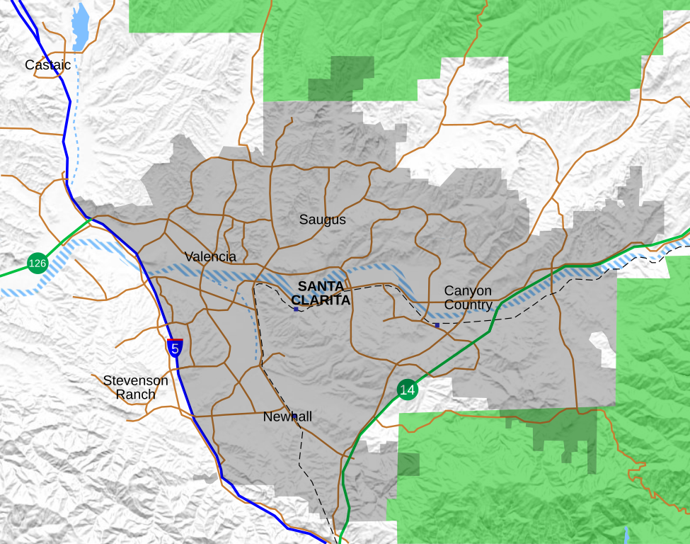
English: Location map for the Santa Clarita Valley in southern California. The scope of the map includes the entire city of Santa Clarita, as well as the nearby unincorporated communities of Stevenson Ranch and part of Castaic.
Legend: Interstate 5
California State Routes (14 and 126)
Major surface streets
Metrolink rail line
Metrolink station (blue boxes)
Santa Clarita city limit (as of 2021)
Permanent bodies of water
Intermittent bodies of water (Santa Clara River and tributaries)
Angeles National Forest |
| Date | |
| Source | Own work, with data from OpenStreetMap. Shaded relief derived from USGS. |
| Author | Crossover1370 |
Licensing
I, the copyright holder of this work, hereby publish it under the following license:
This file is licensed under the
Creative Commons
Attribution-Share Alike 4.0 International license.
- You are free:
- to share – to copy, distribute and transmit the work
- to remix – to adapt the work
- Under the following conditions:
- attribution – You must give appropriate credit, provide a link to the license, and indicate if changes were made. You may do so in any reasonable manner, but not in any way that suggests the licensor endorses you or your use.
- share alike – If you remix, transform, or build upon the material, you must distribute your contributions under the same or compatible license as the original.
File history
Click on a date/time to view the file as it appeared at that time.
| Date/Time | Thumbnail | Dimensions | User | Comment | |
|---|---|---|---|---|---|
| current | 21:05, 24 September 2021 |
| 796 × 627 (1.89 MB) | Crossover1370 | Remove the relatively minor Canyon Park Blvd and Lost Canyon Rd, and add Tourney Rd, a major street home to numerous hotels, government, and medical offices. |
| 21:47, 21 September 2021 |
| 796 × 627 (1.89 MB) | Crossover1370 | A few minor changes involving 3-D placement of certain roads and railroads | |
| 22:56, 20 September 2021 |
| 796 × 627 (1.89 MB) | Crossover1370 | Move the word "Santa Clarita" to top to allow it to be selected like the neighborhood names (no visible difference) | |
| 22:11, 20 September 2021 |
| 796 × 627 (1.89 MB) | Crossover1370 | Sand Canyon Road and Newhall Ranch Road both pass above their respective freeways. Also add Metrolink stations. | |
| 01:15, 20 September 2021 |
| 796 × 627 (1.89 MB) | Crossover1370 | Correct 3D position of streets relative to I-5, rearrange certain objects | |
| 07:01, 19 September 2021 |
| 796 × 627 (1.89 MB) | Crossover1370 | Changed outline of Santa Clarita to shading, add Metrolink train and more streets | |
| 18:31, 26 March 2021 |
| 797 × 628 (1,015 KB) | Crossover1370 | Remove section of Placerita Canyon Road west of Sierra Highway - not a major street. | |
| 01:23, 26 March 2021 |
| 797 × 628 (1,016 KB) | Crossover1370 | Removed some minor streets I added in the previous revision. | |
| 07:11, 25 March 2021 |
| 797 × 628 (1,016 KB) | Crossover1370 | Added more major streets. | |
| 05:10, 23 December 2020 |
| 797 × 628 (1,013 KB) | Crossover1370 | Santa Clara River is still a big black blob. Hopefully this will fix it. |
File usage
The following pages on the English Wikipedia use this file (pages on other projects are not listed):
- 2019 Saugus High School shooting
- Beale's Cut Stagecoach Pass
- Canyon Country, Santa Clarita, California
- Castaic, California
- Castaic Junction, California
- Central Park (Santa Clarita)
- College of the Canyons
- Dry Canyon Reservoir
- Gibbon Conservation Center
- Golden Oak Ranch
- Lang Southern Pacific Station
- Lyons Station Stagecoach Stop
- Master's University
- McBean Regional Transit Center
- Mentryville, California
- Newhall, Santa Clarita, California
- Newhall Pass
- Newhall incident
- Peter J. Pitchess Detention Center
- Pioneer Oil Refinery
- Placerita Canyon State Park
- Rancho San Francisco
- Sand Canyon, Santa Clarita, California
- Santa Clarita, California
- Santa Clarita Woodlands Park
- Saugus, Santa Clarita, California
- Six Flags Magic Mountain
- Stevenson Ranch, California
- Valencia, California
- Valencia, Santa Clarita, California
- Valencia Country Club
- William S. Hart Regional Park
- User:Crossover1370
- Module:Location map/data/Santa Clarita
- Module:Location map/data/Santa Clarita/doc
Global file usage
The following other wikis use this file:
- Usage on fy.wikipedia.org
- Usage on si.wikipedia.org
- Usage on sv.wikipedia.org
- Usage on zh.wikipedia.org