
Size of this preview:
800 × 448 pixels. Other resolutions:
320 × 179 pixels |
640 × 358 pixels |
1,024 × 573 pixels |
1,280 × 716 pixels |
2,560 × 1,433 pixels |
3,777 × 2,114 pixels.
Original file (3,777 × 2,114 pixels, file size: 1.81 MB, MIME type: image/jpeg)
| This is a file from the
Wikimedia Commons. Information from its
description page there is shown below. Commons is a freely licensed media file repository. You can help. |
Summary
| Description |
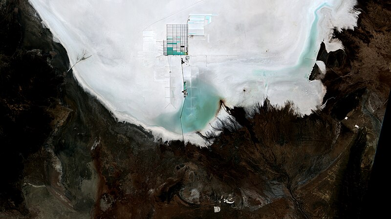
English: Lithium mine at Bolivia´s Uyuni Salt Flat, on a CBERS4 MUX yesterday´s image. That´s the highest and largest salt flat in the World at 12,000 feet and 3,100 sq mi. Covered by a thick salt crust, appearing in white, it is completely flat. Lithium rich brine covered areas appear in green and light blue. Brine evaporation pools, part of lithium extraction process, appear on a checkered pattern with 3 miles from North to South.
Português: Mina de lítio no Salar de Uyuni na Bolívia, em imagem CBERS4 MUX de ontem. A uma altitude de 3.700m, o deserto de sal de Uyuni é o maior do mundo com 8.000 km2. É coberto com uma crosta de sal, em cor branca, de alguns metros e é completamente plano. Áreas em verde e azul claro estão cobertas por salmoura, uma solução concentrada de sal em água, rica em lítio. As piscinas para evaporação e concentração da salmora, parte do processo de extração do lítio, aparecem em um padrão quadriculado, com 5 km de Norte a Sul.
Deutsch: Lithiummine am Salar de Uyuni in Bolivien. Mit einer Höhe von 3.700 m ist die Salzwüste von Uyuni mit 8.000 km2 die größte der Welt. Sie ist mit einer weißen Salzkruste bedeckt, die einige Meter dick und völlig flach ist. Die grün und hellblau gefärbten Gebiete sind von Sole bedeckt, einer konzentrierten Lösung von Salz in Wasser, die reich an Lithium ist. Die Becken zum Verdampfen und Konzentrieren der Sole, Teil des Lithiumgewinnungsprozesses, erscheinen in einem Gittermuster, 5 km von Norden nach Süden.
More info and on the ground pics at:
|
| Date | |
| Source | https://www.flickr.com/photos/153282474@N02/43000042851/ |
| Author | Oton Barros (DSR/OBT/INPE), Coordenação-Geral de Observação da Terra/INPE, http://www.dsr.inpe.br |
Licensing
This file is licensed under the
Creative Commons
Attribution-Share Alike 2.0 Generic license.
- You are free:
- to share – to copy, distribute and transmit the work
- to remix – to adapt the work
- Under the following conditions:
- attribution – You must give appropriate credit, provide a link to the license, and indicate if changes were made. You may do so in any reasonable manner, but not in any way that suggests the licensor endorses you or your use.
- share alike – If you remix, transform, or build upon the material, you must distribute your contributions under the same or compatible license as the original.
| This image was originally posted to Flickr by Coordenação-Geral de Observação da Terra/INPE at https://flickr.com/photos/153282474@N02/43000042851. It was reviewed on 9 April 2020 by FlickreviewR 2 and was confirmed to be licensed under the terms of the cc-by-sa-2.0. |
File history
Click on a date/time to view the file as it appeared at that time.
| Date/Time | Thumbnail | Dimensions | User | Comment | |
|---|---|---|---|---|---|
| current | 10:14, 9 April 2020 |
| 3,777 × 2,114 (1.81 MB) | Jo-Jo Eumerus | Uploaded a work by Coordenação-Geral de Observação da Terra/INPE from https://www.flickr.com/photos/153282474@N02/43000042851/ with UploadWizard |
File usage
The following pages on the English Wikipedia use this file (pages on other projects are not listed):
Global file usage
The following other wikis use this file:
- Usage on cs.wikipedia.org
- Usage on es.wikipedia.org
Metadata
Size of this preview:
800 × 448 pixels. Other resolutions:
320 × 179 pixels |
640 × 358 pixels |
1,024 × 573 pixels |
1,280 × 716 pixels |
2,560 × 1,433 pixels |
3,777 × 2,114 pixels.
Original file (3,777 × 2,114 pixels, file size: 1.81 MB, MIME type: image/jpeg)
| This is a file from the
Wikimedia Commons. Information from its
description page there is shown below. Commons is a freely licensed media file repository. You can help. |
Summary
| Description |
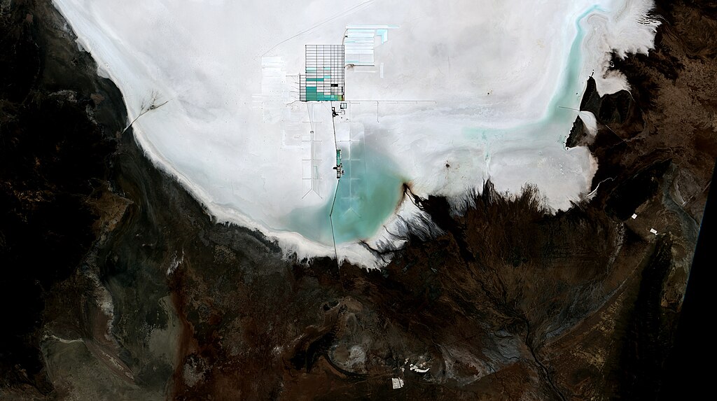
English: Lithium mine at Bolivia´s Uyuni Salt Flat, on a CBERS4 MUX yesterday´s image. That´s the highest and largest salt flat in the World at 12,000 feet and 3,100 sq mi. Covered by a thick salt crust, appearing in white, it is completely flat. Lithium rich brine covered areas appear in green and light blue. Brine evaporation pools, part of lithium extraction process, appear on a checkered pattern with 3 miles from North to South.
Português: Mina de lítio no Salar de Uyuni na Bolívia, em imagem CBERS4 MUX de ontem. A uma altitude de 3.700m, o deserto de sal de Uyuni é o maior do mundo com 8.000 km2. É coberto com uma crosta de sal, em cor branca, de alguns metros e é completamente plano. Áreas em verde e azul claro estão cobertas por salmoura, uma solução concentrada de sal em água, rica em lítio. As piscinas para evaporação e concentração da salmora, parte do processo de extração do lítio, aparecem em um padrão quadriculado, com 5 km de Norte a Sul.
Deutsch: Lithiummine am Salar de Uyuni in Bolivien. Mit einer Höhe von 3.700 m ist die Salzwüste von Uyuni mit 8.000 km2 die größte der Welt. Sie ist mit einer weißen Salzkruste bedeckt, die einige Meter dick und völlig flach ist. Die grün und hellblau gefärbten Gebiete sind von Sole bedeckt, einer konzentrierten Lösung von Salz in Wasser, die reich an Lithium ist. Die Becken zum Verdampfen und Konzentrieren der Sole, Teil des Lithiumgewinnungsprozesses, erscheinen in einem Gittermuster, 5 km von Norden nach Süden.
More info and on the ground pics at:
|
| Date | |
| Source | https://www.flickr.com/photos/153282474@N02/43000042851/ |
| Author | Oton Barros (DSR/OBT/INPE), Coordenação-Geral de Observação da Terra/INPE, http://www.dsr.inpe.br |
Licensing
This file is licensed under the
Creative Commons
Attribution-Share Alike 2.0 Generic license.
- You are free:
- to share – to copy, distribute and transmit the work
- to remix – to adapt the work
- Under the following conditions:
- attribution – You must give appropriate credit, provide a link to the license, and indicate if changes were made. You may do so in any reasonable manner, but not in any way that suggests the licensor endorses you or your use.
- share alike – If you remix, transform, or build upon the material, you must distribute your contributions under the same or compatible license as the original.
| This image was originally posted to Flickr by Coordenação-Geral de Observação da Terra/INPE at https://flickr.com/photos/153282474@N02/43000042851. It was reviewed on 9 April 2020 by FlickreviewR 2 and was confirmed to be licensed under the terms of the cc-by-sa-2.0. |
File history
Click on a date/time to view the file as it appeared at that time.
| Date/Time | Thumbnail | Dimensions | User | Comment | |
|---|---|---|---|---|---|
| current | 10:14, 9 April 2020 |
| 3,777 × 2,114 (1.81 MB) | Jo-Jo Eumerus | Uploaded a work by Coordenação-Geral de Observação da Terra/INPE from https://www.flickr.com/photos/153282474@N02/43000042851/ with UploadWizard |
File usage
The following pages on the English Wikipedia use this file (pages on other projects are not listed):
Global file usage
The following other wikis use this file:
- Usage on cs.wikipedia.org
- Usage on es.wikipedia.org