Photos • Location


Size of this preview:
777 × 600 pixels. Other resolutions:
311 × 240 pixels |
622 × 480 pixels |
995 × 768 pixels |
1,280 × 988 pixels |
2,560 × 1,976 pixels |
5,850 × 4,516 pixels.
Original file (5,850 × 4,516 pixels, file size: 6.07 MB, MIME type: image/jpeg)
| This is a file from the
Wikimedia Commons. Information from its
description page there is shown below. Commons is a freely licensed media file repository. You can help. |
Summary
| Description |
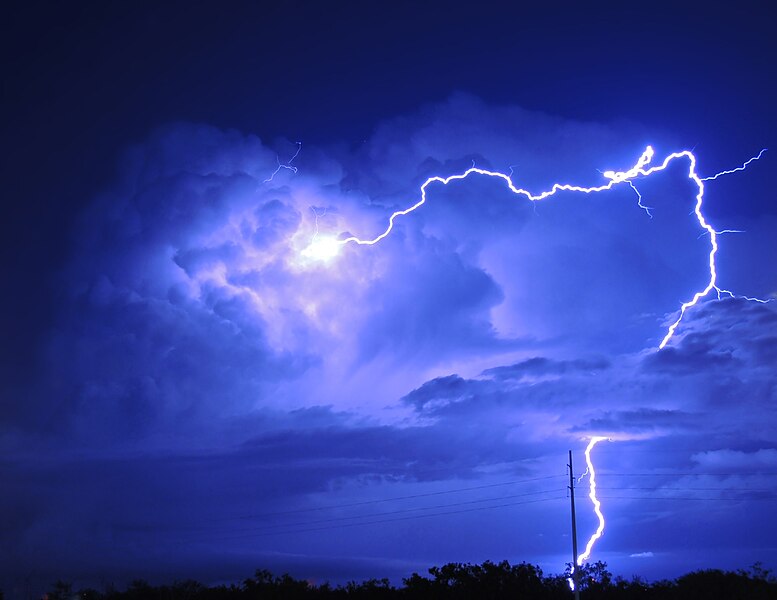
English: On the road from Dallas to Lubbock, TX. This small storm developed shortly after midnight.
   Image ID: con00033, NOAA's National Weather Service (NWS) Collection
   Location: Texas, Snyder
   Photo Date: 2014 June
   Photographer: Mitchel Coombs
Credit: NOAA Weather in Focus Photo Contest 2015 |
| Date | 31 March 2015, 11:32:04 |
| Source | https://www.flickr.com/photos/51647007@N08/27663733200/ |
| Author | NOAA Photo Library |
| Object location |
| View this and other nearby images on: OpenStreetMap |
|
|---|
|
Licensing
| This image was originally posted to Flickr. Its license was verified as "cc-by-2.0" by the UploadWizard Extension at the time it was transferred to Commons. See the license information for further details. |
This file is licensed under the
Creative Commons
Attribution 2.0 Generic license.
- You are free:
- to share – to copy, distribute and transmit the work
- to remix – to adapt the work
- Under the following conditions:
- attribution – You must give appropriate credit, provide a link to the license, and indicate if changes were made. You may do so in any reasonable manner, but not in any way that suggests the licensor endorses you or your use.
This image is in the
public domain because it contains materials that originally came from the U.S.
National Oceanic and Atmospheric Administration, taken or made as part of an employee's official duties.
|
File history
Click on a date/time to view the file as it appeared at that time.
| Date/Time | Thumbnail | Dimensions | User | Comment | |
|---|---|---|---|---|---|
| current | 17:41, 22 July 2016 |
| 5,850 × 4,516 (6.07 MB) | Wilfredor | remove noise |
| 18:48, 12 July 2016 |
 | 5,850 × 4,516 (7.66 MB) | Natuur12 | User created page with UploadWizard |
File usage
The following pages on the English Wikipedia use this file (pages on other projects are not listed):
Global file usage
The following other wikis use this file:
- Usage on cs.wikipedia.org
- Usage on cy.wikisource.org
- Usage on de.wikipedia.org
- Usage on es.wikipedia.org
- Usage on fr.wikipedia.org
- Usage on nl.wikipedia.org
- Usage on sh.wikipedia.org
Metadata
Size of this preview:
777 × 600 pixels. Other resolutions:
311 × 240 pixels |
622 × 480 pixels |
995 × 768 pixels |
1,280 × 988 pixels |
2,560 × 1,976 pixels |
5,850 × 4,516 pixels.
Original file (5,850 × 4,516 pixels, file size: 6.07 MB, MIME type: image/jpeg)
| This is a file from the
Wikimedia Commons. Information from its
description page there is shown below. Commons is a freely licensed media file repository. You can help. |
Summary
| Description |
English: On the road from Dallas to Lubbock, TX. This small storm developed shortly after midnight.
   Image ID: con00033, NOAA's National Weather Service (NWS) Collection
   Location: Texas, Snyder
   Photo Date: 2014 June
   Photographer: Mitchel Coombs
Credit: NOAA Weather in Focus Photo Contest 2015 |
| Date | 31 March 2015, 11:32:04 |
| Source | https://www.flickr.com/photos/51647007@N08/27663733200/ |
| Author | NOAA Photo Library |
| Object location |
| View this and other nearby images on: OpenStreetMap |
|
|---|
|
Licensing
| This image was originally posted to Flickr. Its license was verified as "cc-by-2.0" by the UploadWizard Extension at the time it was transferred to Commons. See the license information for further details. |
This file is licensed under the
Creative Commons
Attribution 2.0 Generic license.
- You are free:
- to share – to copy, distribute and transmit the work
- to remix – to adapt the work
- Under the following conditions:
- attribution – You must give appropriate credit, provide a link to the license, and indicate if changes were made. You may do so in any reasonable manner, but not in any way that suggests the licensor endorses you or your use.
This image is in the
public domain because it contains materials that originally came from the U.S.
National Oceanic and Atmospheric Administration, taken or made as part of an employee's official duties.
|
File history
Click on a date/time to view the file as it appeared at that time.
| Date/Time | Thumbnail | Dimensions | User | Comment | |
|---|---|---|---|---|---|
| current | 17:41, 22 July 2016 |
| 5,850 × 4,516 (6.07 MB) | Wilfredor | remove noise |
| 18:48, 12 July 2016 |
| 5,850 × 4,516 (7.66 MB) | Natuur12 | User created page with UploadWizard |
File usage
The following pages on the English Wikipedia use this file (pages on other projects are not listed):
Global file usage
The following other wikis use this file:
- Usage on cs.wikipedia.org
- Usage on cy.wikisource.org
- Usage on de.wikipedia.org
- Usage on es.wikipedia.org
- Usage on fr.wikipedia.org
- Usage on nl.wikipedia.org
- Usage on sh.wikipedia.org