Photos • Location


Size of this preview:
443 × 599 pixels. Other resolutions:
177 × 240 pixels |
355 × 480 pixels |
568 × 768 pixels |
1,183 × 1,600 pixels.
Original file (1,183 × 1,600 pixels, file size: 446 KB, MIME type: image/jpeg)
| This is a file from the
Wikimedia Commons. Information from its
description page there is shown below. Commons is a freely licensed media file repository. You can help. |
Summary
| Description |
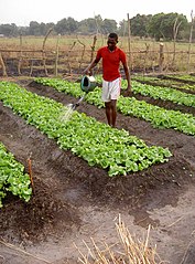
Deutsch: Bewässerung eines Salatfeldes in der Präfektur
Ouham Zentralafrikanischen Republik. Die humanitäre Krise in der Zentralafrikanischen Republik hat die in der landwirtschaft tätigen 74% der Bevölkerung vor große Schwierigkeiten gestellt.
English: Boston lettuce plantation in northern CAR. The humanitarian crisis striking CAR has put the 74 percent of the population working in the Agricultural sector in great difficulty. |
| Date | |
| Source | Watering the lettuce |
| Author |
|
| Camera location |
| View this and other nearby images on: OpenStreetMap |
|
|---|

|
Although this work is freely licensed or in the public domain, the person(s) shown may have rights that legally restrict certain re-uses unless those depicted consent to such uses. In these cases, a model release or other evidence of consent could protect you from infringement claims. Though not obliged to do so, the uploader may be able to help you to obtain such evidence. See our general disclaimer for more information. |
Licensing
This file is licensed under the
Creative Commons
Attribution 2.0 Generic license.
- You are free:
- to share – to copy, distribute and transmit the work
- to remix – to adapt the work
- Under the following conditions:
- attribution – You must give appropriate credit, provide a link to the license, and indicate if changes were made. You may do so in any reasonable manner, but not in any way that suggests the licensor endorses you or your use.
| This image, originally posted to Flickr, was reviewed on December 6, 2008 by the administrator or reviewer File Upload Bot (Magnus Manske), who confirmed that it was available on Flickr under the stated license on that date. |
File history
Click on a date/time to view the file as it appeared at that time.
| Date/Time | Thumbnail | Dimensions | User | Comment | |
|---|---|---|---|---|---|
| current | 23:01, 6 December 2008 |
| 1,183 × 1,600 (446 KB) | File Upload Bot (Magnus Manske) | {{Information |Description= The humanitarian crisis striking CAR has put the 74 percent of the population working in the Agricultural sector in great difficulty. The FAO missionin CAR is supporting the efforts of the population in the North of the count |
File usage
The following pages on the English Wikipedia use this file (pages on other projects are not listed):
Global file usage
The following other wikis use this file:
- Usage on ami.wikipedia.org
- Usage on cs.wikipedia.org
- Usage on fa.wikipedia.org
- Usage on fr.wikipedia.org
- Usage on pl.wikipedia.org
- Usage on zh.wikipedia.org
Metadata
Size of this preview:
443 × 599 pixels. Other resolutions:
177 × 240 pixels |
355 × 480 pixels |
568 × 768 pixels |
1,183 × 1,600 pixels.
Original file (1,183 × 1,600 pixels, file size: 446 KB, MIME type: image/jpeg)
| This is a file from the
Wikimedia Commons. Information from its
description page there is shown below. Commons is a freely licensed media file repository. You can help. |
Summary
| Description |
Deutsch: Bewässerung eines Salatfeldes in der Präfektur
Ouham Zentralafrikanischen Republik. Die humanitäre Krise in der Zentralafrikanischen Republik hat die in der landwirtschaft tätigen 74% der Bevölkerung vor große Schwierigkeiten gestellt.
English: Boston lettuce plantation in northern CAR. The humanitarian crisis striking CAR has put the 74 percent of the population working in the Agricultural sector in great difficulty. |
| Date | |
| Source | Watering the lettuce |
| Author |
|
| Camera location |
| View this and other nearby images on: OpenStreetMap |
|
|---|
|
|
Although this work is freely licensed or in the public domain, the person(s) shown may have rights that legally restrict certain re-uses unless those depicted consent to such uses. In these cases, a model release or other evidence of consent could protect you from infringement claims. Though not obliged to do so, the uploader may be able to help you to obtain such evidence. See our general disclaimer for more information. |
Licensing
This file is licensed under the
Creative Commons
Attribution 2.0 Generic license.
- You are free:
- to share – to copy, distribute and transmit the work
- to remix – to adapt the work
- Under the following conditions:
- attribution – You must give appropriate credit, provide a link to the license, and indicate if changes were made. You may do so in any reasonable manner, but not in any way that suggests the licensor endorses you or your use.
| This image, originally posted to Flickr, was reviewed on December 6, 2008 by the administrator or reviewer File Upload Bot (Magnus Manske), who confirmed that it was available on Flickr under the stated license on that date. |
File history
Click on a date/time to view the file as it appeared at that time.
| Date/Time | Thumbnail | Dimensions | User | Comment | |
|---|---|---|---|---|---|
| current | 23:01, 6 December 2008 |
| 1,183 × 1,600 (446 KB) | File Upload Bot (Magnus Manske) | {{Information |Description= The humanitarian crisis striking CAR has put the 74 percent of the population working in the Agricultural sector in great difficulty. The FAO missionin CAR is supporting the efforts of the population in the North of the count |
File usage
The following pages on the English Wikipedia use this file (pages on other projects are not listed):
Global file usage
The following other wikis use this file:
- Usage on ami.wikipedia.org
- Usage on cs.wikipedia.org
- Usage on fa.wikipedia.org
- Usage on fr.wikipedia.org
- Usage on pl.wikipedia.org
- Usage on zh.wikipedia.org