Photos • Location


Size of this preview:
800 × 600 pixels. Other resolutions:
320 × 240 pixels |
640 × 480 pixels |
1,024 × 768 pixels |
1,280 × 960 pixels |
2,560 × 1,920 pixels |
2,816 × 2,112 pixels.
Original file (2,816 × 2,112 pixels, file size: 2.82 MB, MIME type: image/jpeg)
| This is a file from the
Wikimedia Commons. Information from its
description page there is shown below. Commons is a freely licensed media file repository. You can help. |
| Camera location |
| View this and other nearby images on: OpenStreetMap |
|
|---|
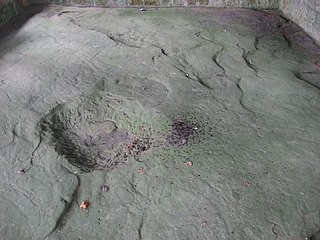
| Description |
English: Comprehensive view from the north of the
Leo Petroglyph, located west of
Leo in
Jackson Township,
Jackson County,
Ohio,
United States. Carved by the prehistoric
Fort Ancient culture, it is listed on the
National Register of Historic Places. |
||
| Date | Taken on 10 July 2010 | ||
| Source | Own work | ||
| Author | Nyttend | ||
| Permission ( Reusing this file) |
|
File history
Click on a date/time to view the file as it appeared at that time.
| Date/Time | Thumbnail | Dimensions | User | Comment | |
|---|---|---|---|---|---|
| current | 04:28, 12 July 2010 |
| 2,816 × 2,112 (2.82 MB) | Nyttend | {{Location|39|8|54|N|82|40|14.5|W}} {{Information |Description={{en|Comprehensive view from the north of the {{w|Leo Petroglyph}}, located west of {{w|Leo, Ohio|Leo}} in {{w|Jackson Township, Jackson County, Ohio|Jackson Township}}, {{w|Jackson County, Oh |
File usage
The following pages on the English Wikipedia use this file (pages on other projects are not listed):
Global file usage
The following other wikis use this file:
- Usage on en.wikivoyage.org
- Usage on fr.wikipedia.org
- Usage on www.wikidata.org
Metadata
Size of this preview:
800 × 600 pixels. Other resolutions:
320 × 240 pixels |
640 × 480 pixels |
1,024 × 768 pixels |
1,280 × 960 pixels |
2,560 × 1,920 pixels |
2,816 × 2,112 pixels.
Original file (2,816 × 2,112 pixels, file size: 2.82 MB, MIME type: image/jpeg)
| This is a file from the
Wikimedia Commons. Information from its
description page there is shown below. Commons is a freely licensed media file repository. You can help. |
| Camera location |
| View this and other nearby images on: OpenStreetMap |
|
|---|
| Description |
English: Comprehensive view from the north of the
Leo Petroglyph, located west of
Leo in
Jackson Township,
Jackson County,
Ohio,
United States. Carved by the prehistoric
Fort Ancient culture, it is listed on the
National Register of Historic Places. |
||
| Date | Taken on 10 July 2010 | ||
| Source | Own work | ||
| Author | Nyttend | ||
| Permission ( Reusing this file) |
|
File history
Click on a date/time to view the file as it appeared at that time.
| Date/Time | Thumbnail | Dimensions | User | Comment | |
|---|---|---|---|---|---|
| current | 04:28, 12 July 2010 |
| 2,816 × 2,112 (2.82 MB) | Nyttend | {{Location|39|8|54|N|82|40|14.5|W}} {{Information |Description={{en|Comprehensive view from the north of the {{w|Leo Petroglyph}}, located west of {{w|Leo, Ohio|Leo}} in {{w|Jackson Township, Jackson County, Ohio|Jackson Township}}, {{w|Jackson County, Oh |
File usage
The following pages on the English Wikipedia use this file (pages on other projects are not listed):
Global file usage
The following other wikis use this file:
- Usage on en.wikivoyage.org
- Usage on fr.wikipedia.org
- Usage on www.wikidata.org