
Size of this preview:
592 × 600 pixels. Other resolutions:
237 × 240 pixels |
474 × 480 pixels |
758 × 768 pixels |
1,010 × 1,024 pixels |
2,000 × 2,027 pixels.
Original file (2,000 × 2,027 pixels, file size: 433 KB, MIME type: image/png)
| This is a file from the
Wikimedia Commons. Information from its
description page there is shown below. Commons is a freely licensed media file repository. You can help. |
Summary
| Description |
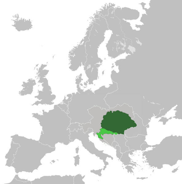
English: Lands of the Crown of Saint Stephen (Kingdom of Hungary and Kingdom of Croatia-Slavonia) in 1914 within Austria-Hungary |
| Date | |
| Source | Own work |
| Author | Tezwoo |
Licensing
I, the copyright holder of this work, hereby publish it under the following license:
This file is licensed under the
Creative Commons
Attribution-Share Alike 3.0 Unported license.
- You are free:
- to share – to copy, distribute and transmit the work
- to remix – to adapt the work
- Under the following conditions:
- attribution – You must give appropriate credit, provide a link to the license, and indicate if changes were made. You may do so in any reasonable manner, but not in any way that suggests the licensor endorses you or your use.
- share alike – If you remix, transform, or build upon the material, you must distribute your contributions under the same or compatible license as the original.
File history
Click on a date/time to view the file as it appeared at that time.
| Date/Time | Thumbnail | Dimensions | User | Comment | |
|---|---|---|---|---|---|
| current | 18:14, 18 May 2021 |
| 2,000 × 2,027 (433 KB) | DonutEater13 | Actually fixed a small spot that was in the middle of the Adriatic sea since the first alteration. (uploaded wrong version first time) |
| 18:09, 18 May 2021 |
 | 2,000 × 2,027 (439 KB) | DonutEater13 | Reverted to version as of 12:57, 24 May 2019 (UTC) | |
| 18:00, 18 May 2021 |
 | 2,000 × 2,027 (433 KB) | DonutEater13 | Fixed a small spot that was in the middle of the Adriatic sea since the first alteration. | |
| 12:57, 24 May 2019 |
 | 2,000 × 2,027 (439 KB) | Koreanovsky | Since this map shows us the situation 1914 and Bosnia-Herzegovina was occupied by both Austria and Hungary, we would have to put a border over there. Otherwise it would look like an Cisleithanian crownland. | |
| 05:15, 17 April 2019 |
 | 2,000 × 2,027 (553 KB) | Fakirbakir | Medimurje was Hungarian | |
| 00:11, 13 May 2014 |
 | 2,000 × 2,027 (551 KB) | Tezwoo | User created page with UploadWizard |
File usage
The following pages on the English Wikipedia use this file (pages on other projects are not listed):
Global file usage
The following other wikis use this file:
- Usage on ar.wikipedia.org
- Usage on azb.wikipedia.org
- Usage on az.wikipedia.org
- Usage on bg.wikipedia.org
- Usage on bn.wikipedia.org
- Usage on cs.wikipedia.org
- Usage on de.wikipedia.org
- Usage on el.wikipedia.org
- Usage on es.wikipedia.org
- Usage on fi.wikipedia.org
- Usage on fr.wikipedia.org
- Usage on he.wikipedia.org
- Usage on hr.wikipedia.org
- Usage on hu.wikipedia.org
- Usage on hy.wikipedia.org
- Usage on id.wikipedia.org
- Usage on io.wikipedia.org
- Usage on ko.wikipedia.org
- Usage on lv.wikipedia.org
- Usage on nl.wikipedia.org
- Usage on pl.wikipedia.org
- Usage on pl.wiktionary.org
- Usage on pt.wikipedia.org
- Usage on ro.wikipedia.org
- Usage on rue.wikipedia.org
- Usage on ru.wikipedia.org
- Usage on sco.wikipedia.org
- Usage on simple.wikipedia.org
- Usage on si.wikipedia.org
- Usage on sr.wikipedia.org
- Usage on sv.wikipedia.org
- Usage on ta.wikipedia.org
- Usage on th.wikipedia.org
- Usage on tr.wikipedia.org
- Usage on tt.wikipedia.org
- Usage on uk.wikipedia.org
- Usage on uz.wikipedia.org
- Usage on vi.wikipedia.org
- Usage on zh.wikipedia.org
Metadata
Size of this preview:
592 × 600 pixels. Other resolutions:
237 × 240 pixels |
474 × 480 pixels |
758 × 768 pixels |
1,010 × 1,024 pixels |
2,000 × 2,027 pixels.
Original file (2,000 × 2,027 pixels, file size: 433 KB, MIME type: image/png)
| This is a file from the
Wikimedia Commons. Information from its
description page there is shown below. Commons is a freely licensed media file repository. You can help. |
Summary
| Description |
English: Lands of the Crown of Saint Stephen (Kingdom of Hungary and Kingdom of Croatia-Slavonia) in 1914 within Austria-Hungary |
| Date | |
| Source | Own work |
| Author | Tezwoo |
Licensing
I, the copyright holder of this work, hereby publish it under the following license:
This file is licensed under the
Creative Commons
Attribution-Share Alike 3.0 Unported license.
- You are free:
- to share – to copy, distribute and transmit the work
- to remix – to adapt the work
- Under the following conditions:
- attribution – You must give appropriate credit, provide a link to the license, and indicate if changes were made. You may do so in any reasonable manner, but not in any way that suggests the licensor endorses you or your use.
- share alike – If you remix, transform, or build upon the material, you must distribute your contributions under the same or compatible license as the original.
File history
Click on a date/time to view the file as it appeared at that time.
| Date/Time | Thumbnail | Dimensions | User | Comment | |
|---|---|---|---|---|---|
| current | 18:14, 18 May 2021 |
| 2,000 × 2,027 (433 KB) | DonutEater13 | Actually fixed a small spot that was in the middle of the Adriatic sea since the first alteration. (uploaded wrong version first time) |
| 18:09, 18 May 2021 |
| 2,000 × 2,027 (439 KB) | DonutEater13 | Reverted to version as of 12:57, 24 May 2019 (UTC) | |
| 18:00, 18 May 2021 |
| 2,000 × 2,027 (433 KB) | DonutEater13 | Fixed a small spot that was in the middle of the Adriatic sea since the first alteration. | |
| 12:57, 24 May 2019 |
| 2,000 × 2,027 (439 KB) | Koreanovsky | Since this map shows us the situation 1914 and Bosnia-Herzegovina was occupied by both Austria and Hungary, we would have to put a border over there. Otherwise it would look like an Cisleithanian crownland. | |
| 05:15, 17 April 2019 |
| 2,000 × 2,027 (553 KB) | Fakirbakir | Medimurje was Hungarian | |
| 00:11, 13 May 2014 |
| 2,000 × 2,027 (551 KB) | Tezwoo | User created page with UploadWizard |
File usage
The following pages on the English Wikipedia use this file (pages on other projects are not listed):
Global file usage
The following other wikis use this file:
- Usage on ar.wikipedia.org
- Usage on azb.wikipedia.org
- Usage on az.wikipedia.org
- Usage on bg.wikipedia.org
- Usage on bn.wikipedia.org
- Usage on cs.wikipedia.org
- Usage on de.wikipedia.org
- Usage on el.wikipedia.org
- Usage on es.wikipedia.org
- Usage on fi.wikipedia.org
- Usage on fr.wikipedia.org
- Usage on he.wikipedia.org
- Usage on hr.wikipedia.org
- Usage on hu.wikipedia.org
- Usage on hy.wikipedia.org
- Usage on id.wikipedia.org
- Usage on io.wikipedia.org
- Usage on ko.wikipedia.org
- Usage on lv.wikipedia.org
- Usage on nl.wikipedia.org
- Usage on pl.wikipedia.org
- Usage on pl.wiktionary.org
- Usage on pt.wikipedia.org
- Usage on ro.wikipedia.org
- Usage on rue.wikipedia.org
- Usage on ru.wikipedia.org
- Usage on sco.wikipedia.org
- Usage on simple.wikipedia.org
- Usage on si.wikipedia.org
- Usage on sr.wikipedia.org
- Usage on sv.wikipedia.org
- Usage on ta.wikipedia.org
- Usage on th.wikipedia.org
- Usage on tr.wikipedia.org
- Usage on tt.wikipedia.org
- Usage on uk.wikipedia.org
- Usage on uz.wikipedia.org
- Usage on vi.wikipedia.org
- Usage on zh.wikipedia.org