
Original file (3,511 × 1,746 pixels, file size: 3.45 MB, MIME type: image/jpeg)
| This is a file from the
Wikimedia Commons. Information from its
description page there is shown below. Commons is a freely licensed media file repository. You can help. |
.jpg)
Summary
| Description |
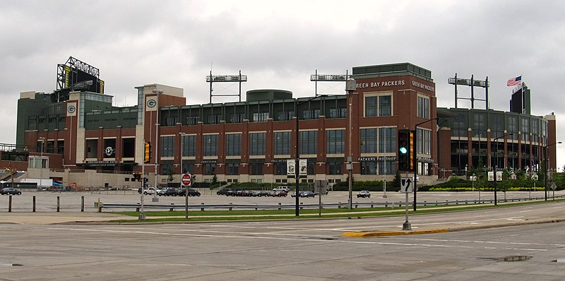
Lambeau Field is the home stadium of the NFL's Green Bay Packers, located in Green Bay, Wisconsin. The stadium opened in 1957 as City Stadium, replacing the original City Stadium as the Packers' home field. For that reason, it was also informally known as New City Stadium until 1965, when it was renamed in memory of Packers founder, player, and long-time head coach, Curly Lambeau, who had died earlier in the year. The stadium's street address has been 1265 Lombardi Avenue since 1968, when Highland Avenue was renamed in honor of Vince Lombardi. It sits on a block bounded by Lombardi Avenue (north); Oneida Street (east); Stadium Drive and Valley View Road (south); and Ridge Road (west). The playing field at the stadium sits at an elevation of 640 feet (195 m) above sea level. Lambeau Field is the N.F.L. stadium continually operated the longest. In 2007, the Packers completed their 51st season at Lambeau, breaking the all-time N.F.L. record set by the Chicago Bears at Wrigley Field (1921–70). (While Soldier Field in Chicago is older, it was not the home of the Bears until 1971.) Only the Boston Red Sox at Fenway Park and the Chicago Cubs at Wrigley have longer active home-field tenures in American professional sports. Although the capacity has more than doubled since Lambeau Field was opened, demand for tickets remains high. The Packers have sold out every game since 1960, and more than 81,000 names remain on the waiting list (with a reported average wait time of 30 years). The sell-out streak has had the effect (intended or not) of ensuring that all Packers home games are televised in Green Bay and Milwaukee, a streak that started in 1973 (prior to that time, local telecasts of home games were disallowed regardless of how many tickets were sold); the Packers are one of four NFL teams (the others being the Washington Redskins, Denver Broncos, and Pittsburgh Steelers) that have not had a home game blacked out since the current blackout rules were put into place. With a capacity of 80,750, Lambeau is now the largest stadium in the state of Wisconsin, beating out Camp Randall Stadium on the campus of the University of Wisconsin–Madison. <a href=" http://en.wikipedia.org/wiki/Lambeau_field" >en.wikipedia.org/wiki/Lambeau_field</a> <a href=" http://en.wikipedia.org/wiki/Wikipedia:Text_of_Creative_Commons_Attribution-ShareAlike_3.0_Unported_License" >en.wikipedia.org/wiki/Wikipedia:Text_of_Creative_Commons_...</a> |
| Date | |
| Source | Lambeau Field, Green Bay, Wisconsin |
| Author | Ken Lund from Reno, Nevada, USA |
| Camera location |
| View this and other nearby images on: OpenStreetMap |
|
|---|
.jpg¶ms=044.501869_N_-088.056750_E_globe:Earth_type:camera_source:Flickr_&language=en)
Licensing
- You are free:
- to share – to copy, distribute and transmit the work
- to remix – to adapt the work
- Under the following conditions:
- attribution – You must give appropriate credit, provide a link to the license, and indicate if changes were made. You may do so in any reasonable manner, but not in any way that suggests the licensor endorses you or your use.
- share alike – If you remix, transform, or build upon the material, you must distribute your contributions under the same or compatible license as the original.
| This image was originally posted to Flickr by Ken Lund at https://flickr.com/photos/75683070@N00/9181850538. It was reviewed on 20 February 2023 by FlickreviewR 2 and was confirmed to be licensed under the terms of the cc-by-sa-2.0. |
File history
Click on a date/time to view the file as it appeared at that time.
| Date/Time | Thumbnail | Dimensions | User | Comment | |
|---|---|---|---|---|---|
| current | 22:48, 20 February 2023 |
| 3,511 × 1,746 (3.45 MB) | SecretName101 | Transferred from Flickr via #flickr2commons |
File usage
Metadata
.jpg)
Original file (3,511 × 1,746 pixels, file size: 3.45 MB, MIME type: image/jpeg)
| This is a file from the
Wikimedia Commons. Information from its
description page there is shown below. Commons is a freely licensed media file repository. You can help. |
Summary
| Description |
Lambeau Field is the home stadium of the NFL's Green Bay Packers, located in Green Bay, Wisconsin. The stadium opened in 1957 as City Stadium, replacing the original City Stadium as the Packers' home field. For that reason, it was also informally known as New City Stadium until 1965, when it was renamed in memory of Packers founder, player, and long-time head coach, Curly Lambeau, who had died earlier in the year. The stadium's street address has been 1265 Lombardi Avenue since 1968, when Highland Avenue was renamed in honor of Vince Lombardi. It sits on a block bounded by Lombardi Avenue (north); Oneida Street (east); Stadium Drive and Valley View Road (south); and Ridge Road (west). The playing field at the stadium sits at an elevation of 640 feet (195 m) above sea level. Lambeau Field is the N.F.L. stadium continually operated the longest. In 2007, the Packers completed their 51st season at Lambeau, breaking the all-time N.F.L. record set by the Chicago Bears at Wrigley Field (1921–70). (While Soldier Field in Chicago is older, it was not the home of the Bears until 1971.) Only the Boston Red Sox at Fenway Park and the Chicago Cubs at Wrigley have longer active home-field tenures in American professional sports. Although the capacity has more than doubled since Lambeau Field was opened, demand for tickets remains high. The Packers have sold out every game since 1960, and more than 81,000 names remain on the waiting list (with a reported average wait time of 30 years). The sell-out streak has had the effect (intended or not) of ensuring that all Packers home games are televised in Green Bay and Milwaukee, a streak that started in 1973 (prior to that time, local telecasts of home games were disallowed regardless of how many tickets were sold); the Packers are one of four NFL teams (the others being the Washington Redskins, Denver Broncos, and Pittsburgh Steelers) that have not had a home game blacked out since the current blackout rules were put into place. With a capacity of 80,750, Lambeau is now the largest stadium in the state of Wisconsin, beating out Camp Randall Stadium on the campus of the University of Wisconsin–Madison. <a href=" http://en.wikipedia.org/wiki/Lambeau_field" >en.wikipedia.org/wiki/Lambeau_field</a> <a href=" http://en.wikipedia.org/wiki/Wikipedia:Text_of_Creative_Commons_Attribution-ShareAlike_3.0_Unported_License" >en.wikipedia.org/wiki/Wikipedia:Text_of_Creative_Commons_...</a> |
| Date | |
| Source | Lambeau Field, Green Bay, Wisconsin |
| Author | Ken Lund from Reno, Nevada, USA |
| Camera location |
| View this and other nearby images on: OpenStreetMap |
|
|---|
Licensing
- You are free:
- to share – to copy, distribute and transmit the work
- to remix – to adapt the work
- Under the following conditions:
- attribution – You must give appropriate credit, provide a link to the license, and indicate if changes were made. You may do so in any reasonable manner, but not in any way that suggests the licensor endorses you or your use.
- share alike – If you remix, transform, or build upon the material, you must distribute your contributions under the same or compatible license as the original.
| This image was originally posted to Flickr by Ken Lund at https://flickr.com/photos/75683070@N00/9181850538. It was reviewed on 20 February 2023 by FlickreviewR 2 and was confirmed to be licensed under the terms of the cc-by-sa-2.0. |
File history
Click on a date/time to view the file as it appeared at that time.
| Date/Time | Thumbnail | Dimensions | User | Comment | |
|---|---|---|---|---|---|
| current | 22:48, 20 February 2023 |
| 3,511 × 1,746 (3.45 MB) | SecretName101 | Transferred from Flickr via #flickr2commons |