
Original file (SVG file, nominally 8,853 √ó 7,502 pixels, file size: 147 KB)
| This is a file from the
Wikimedia Commons. Information from its
description page there is shown below. Commons is a freely licensed media file repository. You can help. |
.svg)
Summary
| Description |
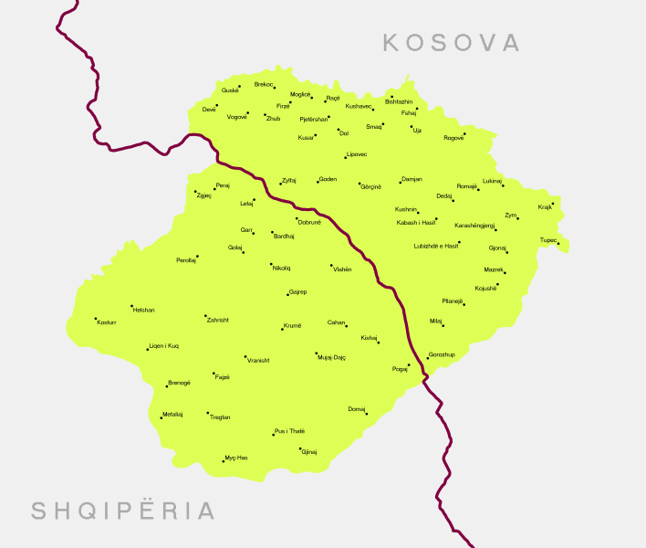
Shqip: Krahina e Hasit
English: Has region
Map data is based on an extensive geographic and ethnographic study of the region.
The boundaries of the region and its settlements shown in the map are based on the cadastral record. The following government based sources were used for the composition of the map. |
| Date | |
| Source | Own work |
| Author | Resnjari |
Licensing
- You are free:
- to share ‚Äď to copy, distribute and transmit the work
- to remix ‚Äď to adapt the work
- Under the following conditions:
- attribution ‚Äď You must give appropriate credit, provide a link to the license, and indicate if changes were made. You may do so in any reasonable manner, but not in any way that suggests the licensor endorses you or your use.
- share alike ‚Äď If you remix, transform, or build upon the material, you must distribute your contributions under the same or compatible license as the original.
File history
Click on a date/time to view the file as it appeared at that time.
| Date/Time | Thumbnail | Dimensions | User | Comment | |
|---|---|---|---|---|---|
| current | 11:16, 7 September 2020 |
| 8,853 √ó 7,502 (147 KB) | Resnjari | Uploaded own work with UploadWizard |
File usage
Global file usage
The following other wikis use this file:
- Usage on sq.wikipedia.org
Metadata
.svg)
Original file (SVG file, nominally 8,853 √ó 7,502 pixels, file size: 147 KB)
| This is a file from the
Wikimedia Commons. Information from its
description page there is shown below. Commons is a freely licensed media file repository. You can help. |
Summary
| Description |
Shqip: Krahina e Hasit
English: Has region
Map data is based on an extensive geographic and ethnographic study of the region.
The boundaries of the region and its settlements shown in the map are based on the cadastral record. The following government based sources were used for the composition of the map. |
| Date | |
| Source | Own work |
| Author | Resnjari |
Licensing
- You are free:
- to share ‚Äď to copy, distribute and transmit the work
- to remix ‚Äď to adapt the work
- Under the following conditions:
- attribution ‚Äď You must give appropriate credit, provide a link to the license, and indicate if changes were made. You may do so in any reasonable manner, but not in any way that suggests the licensor endorses you or your use.
- share alike ‚Äď If you remix, transform, or build upon the material, you must distribute your contributions under the same or compatible license as the original.
File history
Click on a date/time to view the file as it appeared at that time.
| Date/Time | Thumbnail | Dimensions | User | Comment | |
|---|---|---|---|---|---|
| current | 11:16, 7 September 2020 |
| 8,853 √ó 7,502 (147 KB) | Resnjari | Uploaded own work with UploadWizard |
File usage
Global file usage
The following other wikis use this file:
- Usage on sq.wikipedia.org