Photos • Location


Size of this preview:
800 × 468 pixels. Other resolutions:
320 × 187 pixels |
640 × 375 pixels |
1,024 × 599 pixels |
1,280 × 749 pixels |
2,223 × 1,301 pixels.
Original file (2,223 × 1,301 pixels, file size: 531 KB, MIME type: image/jpeg)
| This is a file from the
Wikimedia Commons. Information from its
description page there is shown below. Commons is a freely licensed media file repository. You can help. |
Summary
| Description |
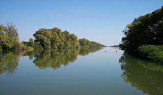
Magyar: A Kettős-Körös
Békésnél a Duzzasztó gátról fényképezve (Magyarország)
|
| Date | |
| Source | Own work |
| Author | László Szalai (Beyond silence) |
| Camera location | | View this and other nearby images on: OpenStreetMap |
|
|---|
Licensing
| I, the copyright holder of this work, release this work into the
public domain. This applies worldwide. In some countries this may not be legally possible; if so: I grant anyone the right to use this work for any purpose, without any conditions, unless such conditions are required by law. |
File history
Click on a date/time to view the file as it appeared at that time.
| Date/Time | Thumbnail | Dimensions | User | Comment | |
|---|---|---|---|---|---|
| current | 21:30, 11 October 2007 |
| 2,223 × 1,301 (531 KB) | Beyond silence | {{Information |Description={{hu|A ''Kettős-Körös'' Békésen a Duzzasztó gátról fényképezve (Magyarország)}} {{en|''Kettős-Körös'' river at Békés, shoted from the floodgate ( Hungary)}} {{self|GFDL|cc-by-sa- |
File usage
The following pages on the English Wikipedia use this file (pages on other projects are not listed):
Global file usage
The following other wikis use this file:
- Usage on az.wikipedia.org
- Usage on ba.wikipedia.org
- Usage on bs.wikipedia.org
- Usage on cs.wikipedia.org
- Usage on da.wikipedia.org
- Usage on de.wikipedia.org
- Usage on en.wikivoyage.org
- Usage on es.wikipedia.org
- Usage on fi.wikipedia.org
- Usage on fr.wikipedia.org
- Usage on hu.wikipedia.org
- Usage on hy.wikipedia.org
- Usage on nl.wikipedia.org
- Usage on pl.wikipedia.org
- Usage on ro.wikipedia.org
- Usage on ru.wikipedia.org
- Usage on sk.wikipedia.org
- Usage on sl.wikipedia.org
- Usage on sr.wikipedia.org
- Usage on tr.wikipedia.org
- Usage on uk.wikipedia.org
- Usage on vi.wikipedia.org
- Usage on www.wikidata.org
- Usage on zh.wikipedia.org
Metadata
Size of this preview:
800 × 468 pixels. Other resolutions:
320 × 187 pixels |
640 × 375 pixels |
1,024 × 599 pixels |
1,280 × 749 pixels |
2,223 × 1,301 pixels.
Original file (2,223 × 1,301 pixels, file size: 531 KB, MIME type: image/jpeg)
| This is a file from the
Wikimedia Commons. Information from its
description page there is shown below. Commons is a freely licensed media file repository. You can help. |
Summary
| Description |
Magyar: A Kettős-Körös
Békésnél a Duzzasztó gátról fényképezve (Magyarország)
|
| Date | |
| Source | Own work |
| Author | László Szalai (Beyond silence) |
| Camera location | | View this and other nearby images on: OpenStreetMap |
|
|---|
Licensing
| I, the copyright holder of this work, release this work into the
public domain. This applies worldwide. In some countries this may not be legally possible; if so: I grant anyone the right to use this work for any purpose, without any conditions, unless such conditions are required by law. |
File history
Click on a date/time to view the file as it appeared at that time.
| Date/Time | Thumbnail | Dimensions | User | Comment | |
|---|---|---|---|---|---|
| current | 21:30, 11 October 2007 |
| 2,223 × 1,301 (531 KB) | Beyond silence | {{Information |Description={{hu|A ''Kettős-Körös'' Békésen a Duzzasztó gátról fényképezve (Magyarország)}} {{en|''Kettős-Körös'' river at Békés, shoted from the floodgate ( Hungary)}} {{self|GFDL|cc-by-sa- |
File usage
The following pages on the English Wikipedia use this file (pages on other projects are not listed):
Global file usage
The following other wikis use this file:
- Usage on az.wikipedia.org
- Usage on ba.wikipedia.org
- Usage on bs.wikipedia.org
- Usage on cs.wikipedia.org
- Usage on da.wikipedia.org
- Usage on de.wikipedia.org
- Usage on en.wikivoyage.org
- Usage on es.wikipedia.org
- Usage on fi.wikipedia.org
- Usage on fr.wikipedia.org
- Usage on hu.wikipedia.org
- Usage on hy.wikipedia.org
- Usage on nl.wikipedia.org
- Usage on pl.wikipedia.org
- Usage on ro.wikipedia.org
- Usage on ru.wikipedia.org
- Usage on sk.wikipedia.org
- Usage on sl.wikipedia.org
- Usage on sr.wikipedia.org
- Usage on tr.wikipedia.org
- Usage on uk.wikipedia.org
- Usage on vi.wikipedia.org
- Usage on www.wikidata.org
- Usage on zh.wikipedia.org