
Size of this preview:
800 × 513 pixels. Other resolutions:
320 × 205 pixels |
640 × 411 pixels |
1,024 × 657 pixels |
1,247 × 800 pixels.
Original file (1,247 × 800 pixels, file size: 484 KB, MIME type: image/png)
| This is a file from the
Wikimedia Commons. Information from its
description page there is shown below. Commons is a freely licensed media file repository. You can help. |
Summary
| Description |
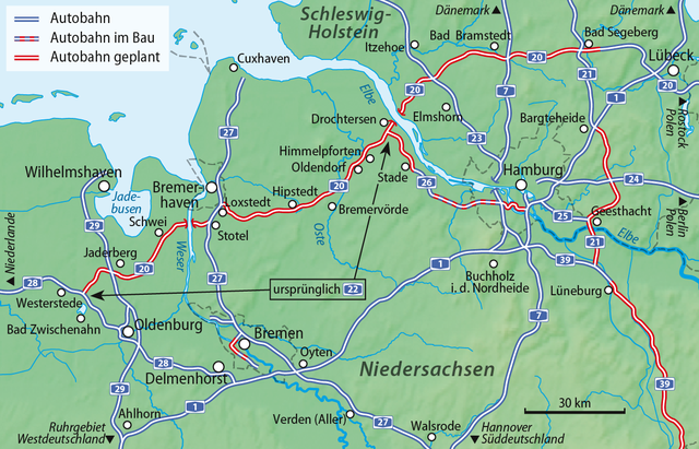
Deutsch: Verlauf des Westteils der
Bundesautobahn 20, ursprünglich als
Bundesautobahn 22 (Westerstede–Drochtersen) geplant
English: Map of the western part of
Bundesautobahn 20, originally planned as
Bundesautobahn 22 (Westerstede–Drochtersen) |
| Date | |
| Source |
own work, using a shading by Lencer, see Deutschland Übersichtskarte.png |
| Author | NordNordWest |

|
This map has been made or improved in the German
Kartenwerkstatt (Map Lab). You can
propose maps to improve as well.
|
Licensing
I, the copyright holder of this work, hereby publish it under the following licenses:

|
Permission is granted to copy, distribute and/or modify this document under the terms of the GNU Free Documentation License, Version 1.2 or any later version published by the Free Software Foundation; with no Invariant Sections, no Front-Cover Texts, and no Back-Cover Texts. A copy of the license is included in the section entitled GNU Free Documentation License. |
This file is licensed under the
Creative Commons
Attribution-Share Alike 3.0 Unported license.
- You are free:
- to share – to copy, distribute and transmit the work
- to remix – to adapt the work
- Under the following conditions:
- attribution – You must give appropriate credit, provide a link to the license, and indicate if changes were made. You may do so in any reasonable manner, but not in any way that suggests the licensor endorses you or your use.
- share alike – If you remix, transform, or build upon the material, you must distribute your contributions under the same or compatible license as the original.
You may select the license of your choice.
File history
Click on a date/time to view the file as it appeared at that time.
| Date/Time | Thumbnail | Dimensions | User | Comment | |
|---|---|---|---|---|---|
| current | 18:08, 11 May 2020 |
| 1,247 × 800 (484 KB) | NordNordWest | corr |
| 18:03, 11 May 2020 |
 | 1,247 × 800 (499 KB) | NordNordWest | upd | |
| 16:17, 8 August 2016 |
 | 1,244 × 797 (1.2 MB) | NordNordWest | upd | |
| 17:55, 9 September 2013 |
 | 1,244 × 797 (1,022 KB) | NordNordWest | upd | |
| 18:18, 26 April 2012 |
 | 1,244 × 797 (1 MB) | NordNordWest | upd | |
| 18:52, 26 October 2011 |
 | 1,244 × 797 (1,018 KB) | NordNordWest | upd | |
| 16:02, 27 January 2011 |
 | 1,244 × 797 (1,015 KB) | NordNordWest | upd | |
| 10:19, 26 June 2010 |
 | 1,244 × 797 (1.14 MB) | NordNordWest | update | |
| 15:12, 23 September 2009 |
 | 1,247 × 801 (1.04 MB) | NordNordWest | ergänzt | |
| 20:29, 18 March 2009 |
 | 1,245 × 798 (1.38 MB) | NordNordWest | corr |
File usage
The following pages on the English Wikipedia use this file (pages on other projects are not listed):
Global file usage
The following other wikis use this file:
- Usage on cs.wikipedia.org
- Usage on de.wikipedia.org
- Bundesautobahn 26
- Bundesautobahn 20
- Bundesautobahn 21
- Wikipedia:Kartenwerkstatt/Archiv/2009-03
- Wikipedia:Kartenwerkstatt/Archiv/2009-09
- Wikipedia:Kartenwerkstatt/Archiv/2010-06
- Elbquerung (A 20)
- Wikipedia:Kartenwerkstatt/Archiv/2011-10
- Wikipedia:Kartenwerkstatt/Archiv/Zurückgewiesene und zurückgestellte Aufträge 2012
- Benutzer Diskussion:CWitte/Archiv//2009
- Usage on eo.wikipedia.org
- Usage on ja.wikipedia.org
- Usage on nds.wikipedia.org
- Usage on nl.wikipedia.org
- Usage on www.wikidata.org
Metadata
Size of this preview:
800 × 513 pixels. Other resolutions:
320 × 205 pixels |
640 × 411 pixels |
1,024 × 657 pixels |
1,247 × 800 pixels.
Original file (1,247 × 800 pixels, file size: 484 KB, MIME type: image/png)
| This is a file from the
Wikimedia Commons. Information from its
description page there is shown below. Commons is a freely licensed media file repository. You can help. |
Summary
| Description |
Deutsch: Verlauf des Westteils der
Bundesautobahn 20, ursprünglich als
Bundesautobahn 22 (Westerstede–Drochtersen) geplant
English: Map of the western part of
Bundesautobahn 20, originally planned as
Bundesautobahn 22 (Westerstede–Drochtersen) |
| Date | |
| Source |
own work, using a shading by Lencer, see Deutschland Übersichtskarte.png |
| Author | NordNordWest |
|
|
This map has been made or improved in the German
Kartenwerkstatt (Map Lab). You can
propose maps to improve as well.
|
Licensing
I, the copyright holder of this work, hereby publish it under the following licenses:
|
|
Permission is granted to copy, distribute and/or modify this document under the terms of the GNU Free Documentation License, Version 1.2 or any later version published by the Free Software Foundation; with no Invariant Sections, no Front-Cover Texts, and no Back-Cover Texts. A copy of the license is included in the section entitled GNU Free Documentation License. |
This file is licensed under the
Creative Commons
Attribution-Share Alike 3.0 Unported license.
- You are free:
- to share – to copy, distribute and transmit the work
- to remix – to adapt the work
- Under the following conditions:
- attribution – You must give appropriate credit, provide a link to the license, and indicate if changes were made. You may do so in any reasonable manner, but not in any way that suggests the licensor endorses you or your use.
- share alike – If you remix, transform, or build upon the material, you must distribute your contributions under the same or compatible license as the original.
You may select the license of your choice.
File history
Click on a date/time to view the file as it appeared at that time.
| Date/Time | Thumbnail | Dimensions | User | Comment | |
|---|---|---|---|---|---|
| current | 18:08, 11 May 2020 |
| 1,247 × 800 (484 KB) | NordNordWest | corr |
| 18:03, 11 May 2020 |
| 1,247 × 800 (499 KB) | NordNordWest | upd | |
| 16:17, 8 August 2016 |
| 1,244 × 797 (1.2 MB) | NordNordWest | upd | |
| 17:55, 9 September 2013 |
| 1,244 × 797 (1,022 KB) | NordNordWest | upd | |
| 18:18, 26 April 2012 |
| 1,244 × 797 (1 MB) | NordNordWest | upd | |
| 18:52, 26 October 2011 |
| 1,244 × 797 (1,018 KB) | NordNordWest | upd | |
| 16:02, 27 January 2011 |
| 1,244 × 797 (1,015 KB) | NordNordWest | upd | |
| 10:19, 26 June 2010 |
| 1,244 × 797 (1.14 MB) | NordNordWest | update | |
| 15:12, 23 September 2009 |
| 1,247 × 801 (1.04 MB) | NordNordWest | ergänzt | |
| 20:29, 18 March 2009 |
| 1,245 × 798 (1.38 MB) | NordNordWest | corr |
File usage
The following pages on the English Wikipedia use this file (pages on other projects are not listed):
Global file usage
The following other wikis use this file:
- Usage on cs.wikipedia.org
- Usage on de.wikipedia.org
- Bundesautobahn 26
- Bundesautobahn 20
- Bundesautobahn 21
- Wikipedia:Kartenwerkstatt/Archiv/2009-03
- Wikipedia:Kartenwerkstatt/Archiv/2009-09
- Wikipedia:Kartenwerkstatt/Archiv/2010-06
- Elbquerung (A 20)
- Wikipedia:Kartenwerkstatt/Archiv/2011-10
- Wikipedia:Kartenwerkstatt/Archiv/Zurückgewiesene und zurückgestellte Aufträge 2012
- Benutzer Diskussion:CWitte/Archiv//2009
- Usage on eo.wikipedia.org
- Usage on ja.wikipedia.org
- Usage on nds.wikipedia.org
- Usage on nl.wikipedia.org
- Usage on www.wikidata.org