Photos • Location


Size of this preview:
800 × 600 pixels. Other resolutions:
320 × 240 pixels |
640 × 480 pixels |
1,024 × 768 pixels |
1,280 × 960 pixels |
2,560 × 1,920 pixels.
Original file (2,560 × 1,920 pixels, file size: 4.06 MB, MIME type: image/jpeg)
| This is a file from the
Wikimedia Commons. Information from its
description page there is shown below. Commons is a freely licensed media file repository. You can help. |
Summary
| Description |
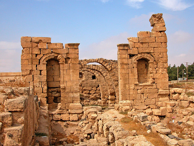
English: Roman and Byzantine Ruins at Er Rabba on the King’s highway. Though there’s not much to see now, it was once an important Roman town on one of strategic military roads. A few Corinthian columns re-erected along the road and the Byzantine church are all that’s left. Jordan
|
||
| Date | |||
| Source | https://www.flickr.com/photos/archer10/2217623806/ | ||
| Author | Dennis Jarvis |
| Camera location |
| View this and other nearby images on: OpenStreetMap |
|
|---|
Licensing
| This image was originally posted to Flickr. Its license was verified as "cc-by-sa-2.0" by the UploadWizard Extension at the time it was transferred to Commons. See the license information for further details. |
This file is licensed under the
Creative Commons
Attribution-Share Alike 2.0 Generic license.
- You are free:
- to share – to copy, distribute and transmit the work
- to remix – to adapt the work
- Under the following conditions:
- attribution – You must give appropriate credit, provide a link to the license, and indicate if changes were made. You may do so in any reasonable manner, but not in any way that suggests the licensor endorses you or your use.
- share alike – If you remix, transform, or build upon the material, you must distribute your contributions under the same or compatible license as the original.

|
This image was uploaded as part of
Wiki Loves Monuments 2014.
|
 |
File history
Click on a date/time to view the file as it appeared at that time.
| Date/Time | Thumbnail | Dimensions | User | Comment | |
|---|---|---|---|---|---|
| current | 15:25, 25 September 2014 |
| 2,560 × 1,920 (4.06 MB) | Tarawneh | User created page with UploadWizard |
File usage
The following pages on the English Wikipedia use this file (pages on other projects are not listed):
Global file usage
The following other wikis use this file:
- Usage on ar.wikipedia.org
Metadata
Size of this preview:
800 × 600 pixels. Other resolutions:
320 × 240 pixels |
640 × 480 pixels |
1,024 × 768 pixels |
1,280 × 960 pixels |
2,560 × 1,920 pixels.
Original file (2,560 × 1,920 pixels, file size: 4.06 MB, MIME type: image/jpeg)
| This is a file from the
Wikimedia Commons. Information from its
description page there is shown below. Commons is a freely licensed media file repository. You can help. |
Summary
| Description |
English: Roman and Byzantine Ruins at Er Rabba on the King’s highway. Though there’s not much to see now, it was once an important Roman town on one of strategic military roads. A few Corinthian columns re-erected along the road and the Byzantine church are all that’s left. Jordan
|
||
| Date | |||
| Source | https://www.flickr.com/photos/archer10/2217623806/ | ||
| Author | Dennis Jarvis |
| Camera location |
| View this and other nearby images on: OpenStreetMap |
|
|---|
Licensing
| This image was originally posted to Flickr. Its license was verified as "cc-by-sa-2.0" by the UploadWizard Extension at the time it was transferred to Commons. See the license information for further details. |
This file is licensed under the
Creative Commons
Attribution-Share Alike 2.0 Generic license.
- You are free:
- to share – to copy, distribute and transmit the work
- to remix – to adapt the work
- Under the following conditions:
- attribution – You must give appropriate credit, provide a link to the license, and indicate if changes were made. You may do so in any reasonable manner, but not in any way that suggests the licensor endorses you or your use.
- share alike – If you remix, transform, or build upon the material, you must distribute your contributions under the same or compatible license as the original.
|
|
This image was uploaded as part of
Wiki Loves Monuments 2014.
|
|
File history
Click on a date/time to view the file as it appeared at that time.
| Date/Time | Thumbnail | Dimensions | User | Comment | |
|---|---|---|---|---|---|
| current | 15:25, 25 September 2014 |
| 2,560 × 1,920 (4.06 MB) | Tarawneh | User created page with UploadWizard |
File usage
The following pages on the English Wikipedia use this file (pages on other projects are not listed):
Global file usage
The following other wikis use this file:
- Usage on ar.wikipedia.org